Hurricane Virgil (1992)

Last updated

Map key
  Tropical depression (≤38 mph, ≤62 km/h)
  Tropical storm (39–73 mph, 63–118 km/h)
  Category 1 (74–95 mph, 119–153 km/h)
  Category 2 (96–110 mph, 154–177 km/h)
  Category 3 (111–129 mph, 178–208 km/h)
  Category 4 (130–156 mph, 209–251 km/h)
  Category 5 (≥157 mph, ≥252 km/h)
  Unknown
Storm type
Disc Plain black.svg Tropical cyclone
Solid black.svg Subtropical cyclone
ArrowUp.svg Extratropical cyclone, remnant low, tropical disturbance, or monsoon depression

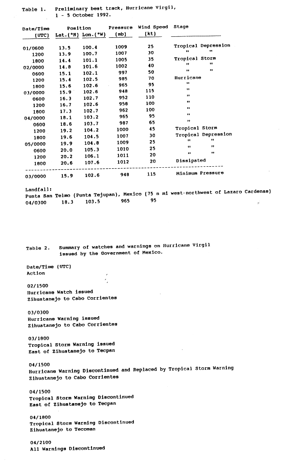
Virgil originated from a tropical wave that moved off the coast of Africa on September 13, 1992, beginning a westward course through the Atlantic and Caribbean without much development, although there was an increase convection near the Lesser Antilles on the September 20. However, this was disorganized and suppressed by an upper-level trough during the wave's passage through the Caribbean Sea. The wave crossed over Panama on September 25, and convection began to increase when it reached the Eastern Pacific, although it was initially disorganized. The system later became better organized, and on October 1, the wave organized into a tropical depression. Shortly thereafter, it was upgraded to a tropical storm and was named Virgil. [1]

Upon becoming a tropical storm, the system was expect to move near the coast of Mexico, and forecasters noted that there was some potential for a landfall. [2] The system became a little better organized and over warm water and low wind shear Virgil steadily intensified. [1] [3] Virgil was upgraded to a hurricane the next day; an eye formed an hour later. During the period of strengthening, Virgil turned more towards the north. [1] Continued strengthening occurred, and it attained major hurricane status on October 2. At this time, the system was anticipated to make landfall in Mexico as a Category 4 hurricane. [4] The storm had maximum winds of 130 mph (215 km/h), but shortly thereafter the storm began to weaken. [1]

By 0900 UTC October 2, the eye started to become less defined. Based on this, the storm was downgraded into a category 3 hurricane. [5] Although an eye was no longer visible on satellite imagery, the storms had displayed very deep convection, thus the NHC initially maintained the intensity at 120 mph (195 km/h). [6] Virgil's eye continued to become less defined, and was downgraded to Category 2 intensity at the time of first landfall on October 4 in Michoacan midway between Manzanillo and Lazaro Cardenas. [1] [7] . After briefly tracking over Manzanillo Bay, the hurricane moved onshore Colima as a Category 1 hurricane. [7] It rapidly weakened over land, and was a dissipating tropical depression by the time it moved offshore. [8]

Preparations and Impact

Prior to the arrival of the hurricane, several watches and warnings were issued. During the afternoon of October 2, a hurricane watch was first issued for areas west of Zinhuantatenjo. The next day, the watch was upgraded into a hurricane warning. Fifteen hours later the area east of Zinhuantatenjo, a tropical storm warning was issued. The watches were gradually dropped over the next few days, and by October 4. [9] The NHC warned the possibility of mudslides and landslides and 15 in (380 mm) of rain in the high terrain of Mexico. [6]

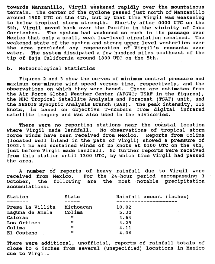
Due to the sparsely populated area it struck, only minor damage was reported. Heavy rain and flooding were reported, peaking at over 10 inches (25 cm) in one location. One person was reported missing in the state of Colima, and three people were injured in Guerrero. More than 1,000 homes were damaged in Guerrero, Michoacán, and Colima, as was 7,400 acres (30 km2) of farmland. A flood on the Atoyac River washed away 500 homes in Guerrero, which prompted the evacuation of 2,500 people. A passenger train north of Lázaro Cárdenas, Michoacán, was derailed when it encountered washed-out roadbeds. [10] The storm also caused power outages. [11]

See also

Related Research Articles

<span class="mw-page-title-main">1992 Atlantic hurricane season</span>

The 1992 Atlantic hurricane season was a significantly below average season for overall tropical or subtropical cyclones as only ten formed. Six of them became named tropical storms, and four of those became hurricanes; one hurricane became a major hurricane. The season was also near-average in terms of accumulated cyclone energy. The season officially started on June 1 and officially ended on November 30. However, tropical cyclogenesis is possible at any time of the year, as demonstrated by formation in April of an unnamed subtropical storm in the central Atlantic.

<span class="mw-page-title-main">2002 Pacific hurricane season</span>

The 2002 Pacific hurricane season was a near–average season which produced fifteen named storms. Eight hurricanes formed, including a record-equaling three Category 5 hurricanes, a record it shares with the 1994 and 2018 seasons. It was also a near-average season in terms of accumulated cyclone energy (ACE), having an ACE of 125. The season officially began on May 15, 2002 in the East Pacific Ocean, and on June 1, 2002 in the Central Pacific; both ended on November 30. These dates conventionally delimit the period of each year when most tropical cyclone formation occurs in these regions of the Pacific. The first system of the 2002 season, Hurricane Alma, formed on May 24, and the last, Tropical Depression Sixteen-E, dissipated on November 16.

<span class="mw-page-title-main">1996 Pacific hurricane season</span>

The 1996 Pacific hurricane season had below normal tropical cyclone activity, producing 9 tropical storms, of which 5 became hurricanes, with 2 of those intensifying into major hurricanes. With an Accumulated cyclone energy (ACE) index of 53.9, the season ranks among the least intense Pacific hurricane seasons on record. It officially began May 15, 1996, in the eastern north Pacific and on June 1, 1996, in the central north Pacific. It ended on November 30, 1996. These dates conventionally delimit the period of each year when most tropical cyclones form in the northeastern Pacific Ocean. The season slightly exceeded these bounds when tropical storm One-E formed on May 13.

<span class="mw-page-title-main">1993 Pacific hurricane season</span>

The 1993 Pacific hurricane season included more than double the average number of major hurricanes – Category 3 or stronger cyclones on the Saffir–Simpson scale. This activity was the result of an El Niño event, which is the main factor contributing to above-average activity across the Pacific basin. The season featured 15 named storms, 11 hurricanes, and 9 major hurricanes. While the number of named storms was near the long-term average, the number of hurricanes was above the average of 8, and the number of major hurricanes far exceeded the long-term average of 4. Seasonal activity began on May 17 and ended on November 8, within the confines of a traditional hurricane season which begins on May 15 in the East Pacific and June 1 in the Central Pacific. The season ends on November 30 in both basins. These dates conventionally delimit the period during each year when most tropical cyclones form.

<span class="mw-page-title-main">1992 Pacific hurricane season</span>

The 1992 Pacific hurricane season is the most active Pacific hurricane season on record, featuring 27 named storms. The season also produced the second-highest ACE value on record in the basin, only surpassed by the 2018 season. The 1992 season officially started on May 15 in the eastern Pacific, and on June 1 in the central Pacific, and lasted until November 30. These dates conventionally delimit the period of each year when most tropical cyclones form in the northeastern Pacific Ocean. However, tropical cyclogenesis is possible at any time of the year, as demonstrated by the development of Hurricane Ekeka on January 28, and Tropical Storm Hali two months later.

<span class="mw-page-title-main">1991 Pacific hurricane season</span>

The 1991 Pacific hurricane season was a near-average Pacific hurricane season. The worst storm this year was Tropical Storm Ignacio, which killed 23 people in Mexico and injured 40 others. Elsewhere, Hurricane Fefa caused flooding in Hawaii. Hurricane Kevin was the strongest system of the season and became the then longest-lasting hurricane in the eastern north Pacific basin at the time, and Hurricane Nora was the strongest November storm to that point. The season officially started on May 15, 1991, in the eastern Pacific, and on June 1, 1991, in the central Pacific. It lasted until November 30, 1991, in both basins. These dates conventionally delimit the period of each year when most tropical cyclones form in the northeastern Pacific Ocean.

<span class="mw-page-title-main">Hurricane Calvin (1993)</span> Category 2 Pacific hurricane in 1993

Hurricane Calvin was one of three Pacific hurricanes on record to make landfall along the Mexican coast during the month of July. The fourth tropical cyclone, third named storm, and second hurricane of the 1993 Pacific hurricane season, Calvin developed from an area of convection to the south of Mexico on July 4. The following day, the system intensified into a tropical storm, which was named Calvin. Continued strengthening ensued as Calvin curved from its initial westward track northward, and was upgraded to a hurricane on July 6. Calvin eventually turned northwest, and became a Category 2 hurricane on the Saffir–Simpson hurricane wind scale (SSHWS). By July 7, Hurricane Calvin made landfall near Manzanillo at peak strength. Calvin rapidly weakened after landfall, and was a tropical storm when it reemerged into the Pacific Ocean on early on July 8. Despite this, the hurricane did not reintensify, and continued to weaken as it headed rapidly northwestward. As Calvin made a second Mexican landfall near the southern tip of Baja California peninsula late on July 8, it weakened to a tropical depression. Early on July 9, the depression dissipated shortly after entering the Pacific Ocean for a third time.

<span class="mw-page-title-main">Hurricane Lester (1998)</span> Category 3 Pacific hurricane in 1998

Hurricane Lester was a small but powerful tropical cyclone that caused heavy flooding in Central America and southern Mexico in October 1998. Lester was the fifteenth tropical cyclone, twelfth named storm and eighth hurricane of the 1998 Pacific hurricane season. Lester originated from a tropical wave that emerged off the coast of Africa on September 29. Under favorable conditions, the storm was classified as a tropical depression on October 15. The depression was upgraded to a tropical storm later that day and a hurricane on October 16. After undergoing fluctuations in intensity, Lester reached peak winds of 115 mph (185 km/h), a Category 3 hurricane on the Saffir-Simpson Hurricane Scale. After several days, it degenerated into a tropical storm on October 26, and dissipated shortly after. The hurricane made its closest approach to land on October 28, producing moderate winds and heavy rainfall. A mudslide triggered by the precipitation killed two children, although damage is unknown.

<span class="mw-page-title-main">Tropical Storm Kiko (2007)</span> Pacific tropical cyclone

Tropical Storm Kiko was a strong tropical storm that capsized a boat off the western coast of Mexico, killing at least 15 people. The 15th and final tropical cyclone of the 2007 Pacific hurricane season, Kiko developed out of a tropical wave that formed off the coast of Africa on September 26 and traversed the Atlantic. The wave crossed over Central America and entered the Pacific Ocean on October 8, where it spawned Tropical Depression 15-E on October 15. The depression drifted to the south over the next day before briefly being declared Tropical Storm Kiko. It subsequently weakened into a tropical depression, but later reattained tropical storm intensity. By October 18, Kiko was forecast to make landfall along the western Mexican coastline as a moderate tropical storm. However, the cyclone turned to the west and reached its peak intensity of 70 mph (110 km/h) on October 20. The tropical storm slowly weakened to a remnant low-pressure area by October 24 and completely dissipated on October 27 without making landfall.

<span class="mw-page-title-main">2006 Pacific hurricane season</span>

The 2006 Pacific hurricane season was the first above-average season since 1997 which produced twenty-five tropical cyclones, with nineteen named storms, though most were rather weak and short-lived. There were eleven hurricanes, of which six became major hurricanes. Following the inactivity of the previous seasons, forecasters predicted that season would be only slightly above active. It was also the first time since 2003 in which one cyclone of at least tropical storm intensity made landfall. The season officially began on May 15 in the East Pacific Ocean, and on June 1 in the Central Pacific; they ended on November 30. These dates conventionally delimit the period of each year when most tropical cyclones form in the Pacific basin. However, the formation of tropical cyclones is possible at any time of the year.

<span class="mw-page-title-main">Hurricane Hernan (1996)</span> Category 1 Pacific hurricane in 1996

Hurricane Hernan was fourth and final tropical cyclone to strike Mexico at hurricane intensity during the 1996 Pacific hurricane season. The thirteenth tropical cyclone, eighth named storm, and fifth hurricane of the season, Hernan developed as a tropical depression from a tropical wave to the south of Mexico on September 30. The depression quickly strengthened, and became Tropical Storm Hernan later that day. Hernan curved north-northwestward the following day, before eventually turning north-northeastward. Still offshore of the Mexican coast on October 2, Hernan intensified into a hurricane. Six hours later, Hernan attained its peak as an 85 mph (140 km/h) Category 1 hurricane on the Saffir-Simpson Hurricane Wind Scale (SSHWS). After weakening somewhat, on 1000 UTC October 3, Hurricane Hernan made landfall near Barra de Navidad, Jalisco, with winds of 75 mph (120 km/h). Only two hours after landfall, Hernan weakened to a tropical storm. By October 4, Tropical Storm Hernan had weakened into a tropical depression, and dissipated over Nayarit on the following day.

<span class="mw-page-title-main">Tropical Storm Norman (2000)</span> Pacific tropical storm in 2000

Tropical Storm Norman was a tropical cyclone that hit Mexico in September 2000. The sixteenth cyclone and fourteenth named storm of the 2000 Pacific hurricane season, Norman originated in a tropical wave that emerged from the coast of Africa on September 4, and moved westward across the Atlantic Ocean; the wave entered the Pacific on September 16. The disturbance organized into a tropical depression on early on September 20, and later that day the storm reached its peak intensity of 50 mph (80 km/h), and subsequently made landfall to the west of Lázaro Cárdenas, Michoacán. After weakening to a tropical depression over land, the storm re-emerged over open waters, and made a second landfall before dissipating shortly thereafter. The storm produced heavy rain that resulted in flooding and mudslides, killing about nine people.

<span class="mw-page-title-main">Tropical Storm Odile (2008)</span> Pacific tropical storm in 2008

Tropical Storm Odile was a late season tropical storm that formed during the 2008 Pacific hurricane season and affected parts of southern Mexico. A tropical depression formed on October 8, and became Tropical Storm Odile 18 hours later. The storm paralleled the south coast of Mexico, with the center located only several miles offshore. After peaking in intensity, increasing southeasterly vertical wind shear induced a trend of rapid weakening on the storm. Correspondingly, Odile was downgraded to a tropical depression early on 12 October, subsequently degenerating into a remnant low about 55 mi (85 km) south of Manzanillo, Colima. From thereon, the low proceeded slowly south-southwestward before dissipating on October 13. Since Odile stayed at sea, its effects along coastlines were limited. The most notable damages were caused by flooding along the southern coast of Mexico, mostly in Chiapas, Oaxaca, Guerrero and Michoacán. The exact amount of damage, however, remains unknown, and no fatalities were reported as a result of the storm.

<span class="mw-page-title-main">Tropical Depression Five-E (2008)</span> Pacific tropical depression in 2008

Tropical Depression Five-E was a tropical depression which made landfall along the south-western Mexican coastline in July 2008. It was the fifth tropical cyclone of the 2008 Pacific hurricane season. The depression developed out of a weak tropical wave which formed off the coast of Africa on June 23. The wave remained poorly organized throughout its journey through the Atlantic Ocean and Caribbean Sea. The wave entered the Eastern Pacific on July 2 after passing through Central America. The wave developed into an area of low pressure that afternoon.

<span class="mw-page-title-main">Meteorological history of Hurricane Georges</span>

The meteorological history of Hurricane Georges spanned seventeen days from September 15 to October 1, 1998. Hurricane Georges began as a tropical wave that moved off the coast of Africa during mid-September 1998. Tracking westward, the wave spawned an area of low pressure two days later, which quickly strengthened into a tropical depression. On September 16, the depression was upgraded to Tropical Storm Georges, and to Hurricane Georges the next day. Over the next few days, an eye developed and deep Atmospheric convection persisted around it. Strong outflow and warm sea surface temperatures allowed the storm to intensify as it tracked towards the west-northwest. The storm reached its peak intensity on September 20 with winds of 155 mph (250 km/h), just below Category 5 status on the Saffir–Simpson hurricane scale, and a barometric pressure of 937 mbar.

<span class="mw-page-title-main">Tropical Storm Carlos (2003)</span> Pacific tropical storm in 2003

Tropical Storm Carlos was the first of five tropical cyclones to make landfall during the 2003 Pacific hurricane season. It formed on June 26 from a tropical wave to the south of Mexico. It quickly strengthened as it approached the coast, and early on June 27 Carlos moved ashore in Oaxaca with winds of 65 mph (105 km/h). The storm rapidly deteriorated to a remnant low, which persisted until dissipating on June 29. Carlos brought heavy rainfall to portions of southern Mexico, peaking at 337 mm (13.3 in) in two locations in Guerrero. Throughout its path, the storm damaged about 30,000 houses, with a monetary damage total of 86.7 million pesos. At least nine people were killed throughout the country, seven due to mudslides and two from river flooding; there was also a report of two missing fishermen.

<span class="mw-page-title-main">Hurricane Winifred</span> Category 3 Pacific hurricane in 1992

Hurricane Winifred was the last tropical cyclone to make landfall in the record-breaking 1992 Pacific hurricane season. Impacting western Mexico, especially Colima and Michoacán, Hurricane Winifred brought heavy rain and destruction to the area. Rains flooded farms and roads, and caused more than $5 million in damage and a total of three people were killed.

<span class="mw-page-title-main">Hurricane Ingrid</span> Category 1 Atlantic hurricane in 2013

Hurricane Ingrid was one of two tropical cyclones, along with Hurricane Manuel, to strike Mexico within a 24-hour period, the first such occurrence since 1958. Ingrid was the ninth named storm and second hurricane of the 2013 Atlantic hurricane season. It formed on September 12 in the Gulf of Mexico from a broad disturbance that also spawned Manuel in the eastern Pacific. After initially moving westward toward Veracruz, Ingrid turned northeastward away from the coast. Favorable conditions allowed it to attain hurricane status on September 14, and the next day Ingrid attained peak winds of 140 km/h (85 mph). Subsequently, increased wind shear weakened the convection as the storm turned more to the northwest and west. On September 16, Ingrid made landfall just south of La Pesca, Tamaulipas in northeastern Mexico as a strong tropical storm, and dissipated the next day. The hurricane was also the last one to form in the Gulf of Mexico until Hurricane Hermine in 2016.

<span class="mw-page-title-main">2021 Pacific hurricane season</span>

The 2021 Pacific hurricane season was a moderately active Pacific hurricane season, with above-average activity in terms of number of named storms, but below-average activity in terms of major hurricanes, as 19 named storms, 8 hurricanes, and 2 major hurricanes formed in all. It also had a near-normal accumulated cyclone energy (ACE). The season officially began on May 15, 2021 in the Eastern Pacific Ocean, and on June 1, 2021, in the Central Pacific in the Northern Hemisphere. The season ended in both regions on November 30, 2021. These dates historically describe the period each year when most tropical cyclogenesis occurs in these regions of the Pacific and are adopted by convention. However, the formation of tropical cyclones is possible at any time of the year, as illustrated by the formation of Tropical Storm Andres on May 9, which was the earliest forming tropical storm on record in the Eastern Pacific. Conversely, 2021 was the second consecutive season in which no tropical cyclones formed in the Central Pacific.

<span class="mw-page-title-main">Hurricane Rick (2021)</span> Category 2 Pacific hurricane in 2021

Hurricane Rick was a Category 2 Pacific hurricane that struck the southwestern coast of Mexico in late October 2021. Rick was the overall seventeenth named system and the eighth hurricane of the 2021 Pacific hurricane season, as well as the fifth named storm and fourth hurricane to make landfall along the Pacific coast of Mexico in 2021.

References

  1. 1 2 3 4 5 Richard J Pasch. "Hurricane Virgil Tropical Cyclone Report Page 1". National Hurricane Center. p. 1. Retrieved April 18, 2010.
  2. Edward N. Rappaport (January 10, 1992). "Tropical Storm Virgil Discussion 3". National Hurricane Center. Retrieved May 8, 2010.
  3. Lixion Avila (October 2, 1992). "Tropical Storm Virgil Discussion 5". National Hurricane Center. Retrieved May 8, 2010.
  4. Edward N. Rappaport (February 10, 1992). "Hurricane Virgil Discussion 7". National Hurricane Center. Retrieved May 8, 2010.
  5. Lixion Alivia (March 10, 1992). "Hurricane Virgil Discussion 9". National Hurricane Center . Retrieved November 26, 2010.
  6. 1 2 Edward N. Rappaport (October 3, 1992). "Hurricane Virgil Discussion 10". National Hurricane Center . Retrieved November 26, 2010.
  7. 1 2 National Hurricane Center; Hurricane Research Division; Central Pacific Hurricane Center (April 26, 2024). "The Northeast and North Central Pacific hurricane database 1949–2023". United States National Oceanic and Atmospheric Administration's National Weather Service. Archived from the original on May 29, 2024. A guide on how to read the database is available here. PD-icon.svg This article incorporates text from this source, which is in the public domain.
  8. Richard J. Pasch. "Hurricane Virgil Tropical Cyclone Report Page 2". National Hurricane Center. p. 2. Retrieved April 18, 2010.
  9. Richard J Pasch. "Hurricane Virgil Tropical Cyclone Report Page 5". National Hurricane Center. p. 2. Retrieved April 18, 2010.
  10. Edward N. Rappaport and Miles B. Lawrence (January 2, 1993). "Eastern Pacific hurricanes: 1992". Monthly Weather Review. 122. National Hurricane Center: 549. doi:10.1175/1520-0493(1994)122<0549:ENPHSO>2.0.CO;2. ISSN   1520-0493 . Retrieved May 30, 2009.
  11. Staff Writer (October 21, 1992). "Tropical Storms". The News. Retrieved May 8, 2010.
Hurricane Virgil
Virgil October 2 1992 2231Z.png
Hurricane Virgil near peak intensity late on October 3