 Norma at its peak intensity while south of the Baja California peninsula on October 19 | |
| Meteorological history | |
|---|---|
| Formed | October 17,2023 |
| Dissipated | October 23,2023 |
| Category 4 major hurricane | |
| 1-minute sustained (SSHWS/NWS) | |
| Highest winds | 130 mph (215 km/h) |
| Lowest pressure | 939 mbar (hPa);27.73 inHg |
| Overall effects | |
| Fatalities | 3 total |
| Damage | $28.4 million (2023 USD) |
| Areas affected | Mexico (Baja California Sur and Sinaloa) |
| [1] [2] [3] | |
Part of the 2023 Pacific hurricane season | |
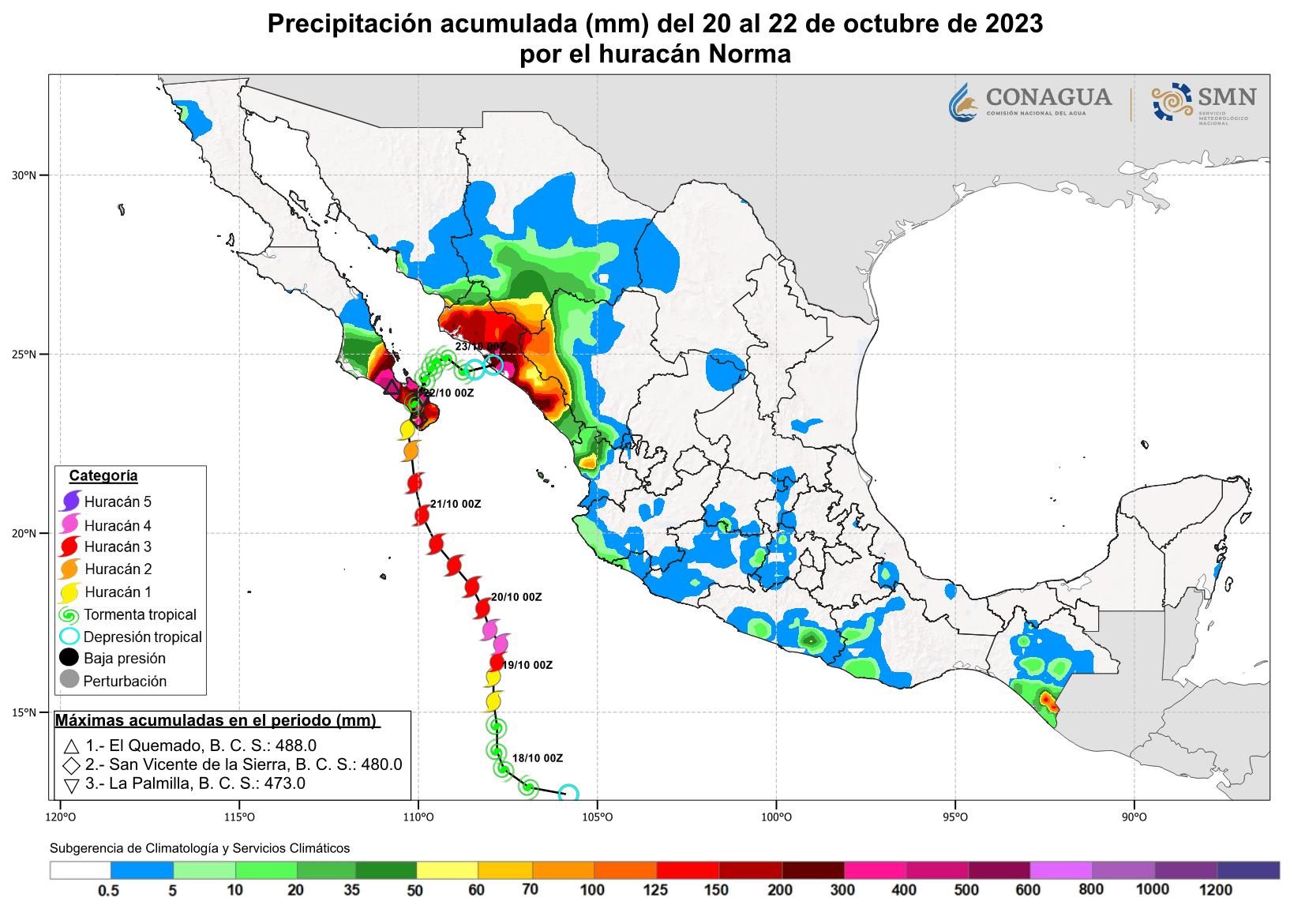
Hurricane Norma was one of four tropical cyclones to strike the Pacific Coast of Mexico in October 2023. The seventeenth tropical depression,fourteenth named storm,ninth hurricane and seventh major hurricane [a] of the 2023 Pacific hurricane season,Norma developed from an area of low pressure that formed off the coast of southern Mexico on October 15,2023. The disturbance gradually organized as it progressed westward parallel to the coast,and developed into Tropical Storm Norma on October 17. Turning northward,Norma rapidly intensified to a Category 4 hurricane as it continued to parallel the west coast of Mexico. Less favorable environmental conditions caused Norma to gradually weaken as it approached the Baja California peninsula. The cyclone made landfall on the Mexican state of Baja California Sur as a Category 1 hurricane. Norma continued to weaken as it crossed the state. The storm emerged over the Gulf of California on October 22,and made landfall as a tropical depression the following day on the state of Sinaloa. Norma quickly dissipated as it moved inland over Mexico.
Contents
- Meteorological history
- Preparations and impact
- Baja California Sur
- Sinaloa
- See also
- Notes
- References
- External links
Norma resulted in extensive flooding across northwestern Mexico,peaking at nearly 480 mm (19 in) in parts of Baja California Sur. Numerous trees,homes and boats were damaged in the cities of Cabo San Lucas and La Paz. Damage across the state amounted to 285 million pesos (US$16 million). [b] Norma resulted in three fatalities in Sinaloa,as well as severe damage to numerous houses and businesses. Infrastructural damage alone in Sinaloa reached 220 million pesos (US$12.4 million).


