Sometime between June and October 1884: a tropical cyclone of unknown intensity made landfall in the peninsula.[2]
July 1902: A tropical cyclone made landfall in Baja California.[3]
August 1915: A tropical cyclone impacted the northern part of Baja California.[3]
September 13, 1918: Twenty-five deaths and heavy damage in La Paz and elsewhere resulted from tropical cyclone of unknown intensity making landfall on this date.[4][5]
August 1921: A tropical cyclone impacted the central part of the Baja California Peninsula.[3]
September 1921: A tropical cyclone's remnants tracked across the Baja California Peninsula.[3]
September 1921: The remnants of a tropical cyclone moved inland after dissipating on this date.[3]
August 1935: A tropical cyclone made landfall in southern Baja California and tracked northwards.[3]
September 1939: In the early part of this month, the first of three tropical cyclones to impact the peninsula this year hit the northern part of the area.[3]
September 1939: In the middle of the month, a tropical cyclone made landfall and promptly dissipated.[3]
September 1939: The third tropical cyclone to impact the peninsula this month hit part of Baja California Sur and dissipated onshore. Its remnants moved north.[3]
August 31, 1967: Hurricane Katrina made landfall on the southern tip of the peninsula and then traveled up through the peninsula.[20] Katrina did heavy damage, sinking 60 ships and leaving 2500 homeless after it partially destroyed the city of San Felipe.[21]
October 14, 1967: Hurricane Olivia becomes the first of only one of three major hurricanes to make landfall on Baja California. No damage figures exist from Olivia due to the scarce population of the area it struck. However, a total of 61 lives were lost.[22]
October 2, 1968: Hurricane Pauline made landfall on the peninsula and crossed it. Four or five people died when a sailboat was sunk in Magdalena Bay.[23]
September 5, 1970: Tropical Depression Norma dissipated just offshore, with its moisture being drawn into an extratropical system further to the north.[24]
October 1, 1976: Hurricane Liza passed close to the southern tip of the Baja California Peninsula. Liza's heavy rains caused a flash flood that burst a dyke near La Paz. The resulting torrent of water did heavy damage and killed at least 435[28] and probably more than 630people.[21]
August 15, 1977: Hurricane Doreen briefly made landfall as it skirted the Pacific coast of the peninsula.[29]
September 29, 1982: Hurricane Paul briefly passed over the extreme southern tip of the peninsula. No damage or casualties were reported.[31]
Late September–Early October 1983: Moisture partially related to Tropical Storm Octave caused widespread rainfall. A total of 12in (300mm) was reported in Altar, along the extreme northern part of the peninsula. Lighter totals between 1–3in (25–75mm) were reported along the southern portion of the peninsula.[32]
Late September 1985: Hurricane Terry was predicted to make landfall in central Baja California and threaten San Diego.[35] However, Terry never made landfall.[36]
Early October 1985: Hurricane Waldo bypasses the Baja California Peninsula;[36] however, moderate rain was recorded along the southern part of the Baja California Peninsula.[37]
October 1, 1986: Hurricane Paine brushed Cabo San Lucas. Heavy precipitation fell in the southern portion of the Baja California Peninsula, and upwards of 7inches (18cm) fell across its path.[39] Strong winds knocked down trees and caused disruptions to city services.[40]
September 20, 1987: Hurricane Norma dissipated a mere 93mi (150km) south of the Baja California Peninsula.[1] There were no reports of damage or flooding from the storm; the area Norma stuck was sparsely populated.[42]
October 1–2, 1987: Tropical Storm Pilar produced the heaviest rain in one location since 1971.[42]
August 27, 1989: Hurricane Kiko made landfall on the Gulf of California side of the peninsula.[43] It caused heavy damage but no deaths.[43][44] Winds gusting to over 109mph (175km/h) brought down numerous trees and power lines.[45]
October 5, 1989: Tropical Storm Raymond made landfall on the peninsula.[46] Since Raymond was moving rapidly, only minor impacts were recorded in Mexico.[47]
Late June 1990: The remnants of Hurricane Boris brought heavy rains to the peninsula.[48][49][50] No direct damages or casualties were reported from Boris.[51]
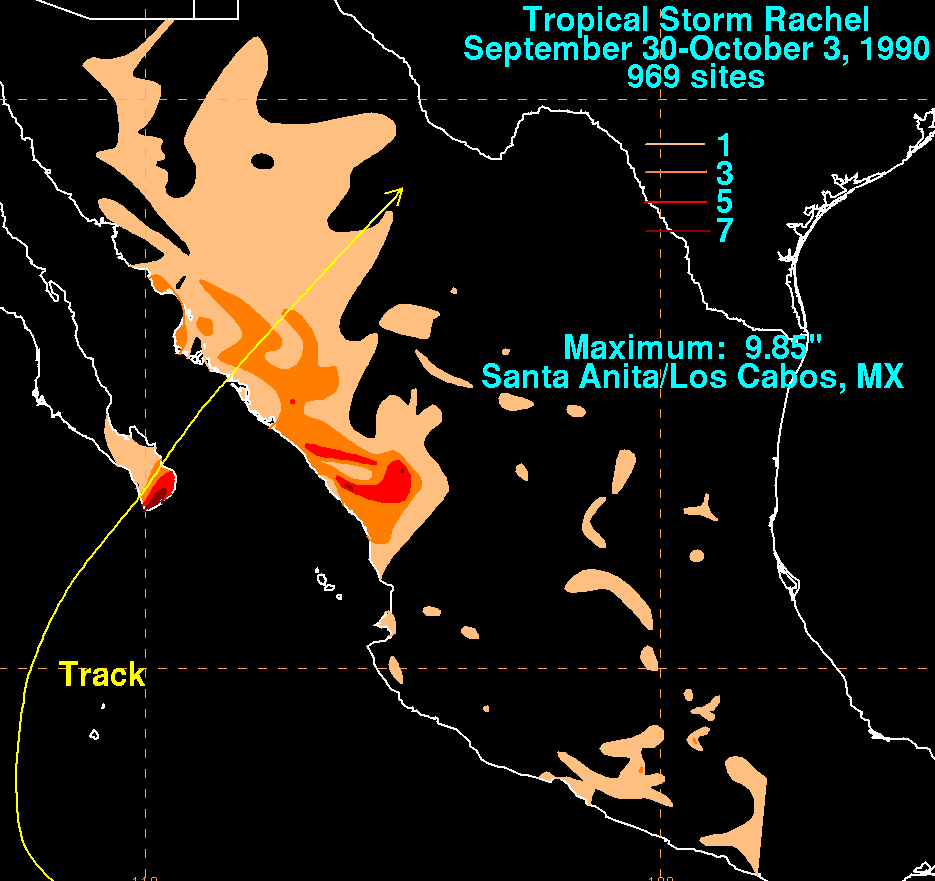
October 2, 1990: Tropical Storm Rachel made landfall on the southern tip of the Baja California Peninsula. No reports of either deaths or damage were received.[52] However, the highest rainfall total from the system in the entire nation totaled 9.85in (250mm) at Santa Anita near the southern tip of Baja California Sur.[53]
August 23, 1992: Hurricane Lester made landfall near Punta Abrejeos as it rapidly crossed the peninsula. There were no reported deaths, but some damage was reported.[54]
July 8, 1993: Tropical Depression Calvin made landfall on the peninsula east-southeast of La Paz. No damage or deaths were reported on the peninsula.[55]
August 25–26, 1993: Tropical Storm Hilary made two landfalls on the peninsula. No deaths or damage were reported.[56]
September 4, 1995: Strong winds, rains, and storm surge from Hurricane Henriette left 800 homeless and caused heavy road damage to the southern part of Baja California Sur. No deaths were reported.[58]
September 13, 1996: Hurricane Fausto made landfall near Todos Santos on the peninsula. The only death was of a vacationer from San Diego. A downed power line electrocuted the vacationer in Cabo San Lucas.[60] Damage elsewhere was appreciable, with downed power lines, smashed windows, and significant disruption throughout the peninsula.[60]
Early August 1997: Hurricane Guillermo produced high waves of up to 12ft (3.7m). These rough ocean conditions flooded homes situated along the coast. Two people were killed after being swept out to sea.[61]
August 14–15, 2000: Tropical Storm Ileana briefly threatened the southern areas of the peninsula before suddenly turning out to sea. Large waves caused by the storm likely impacted the coast of that area. No damage or deaths were reported.[66]
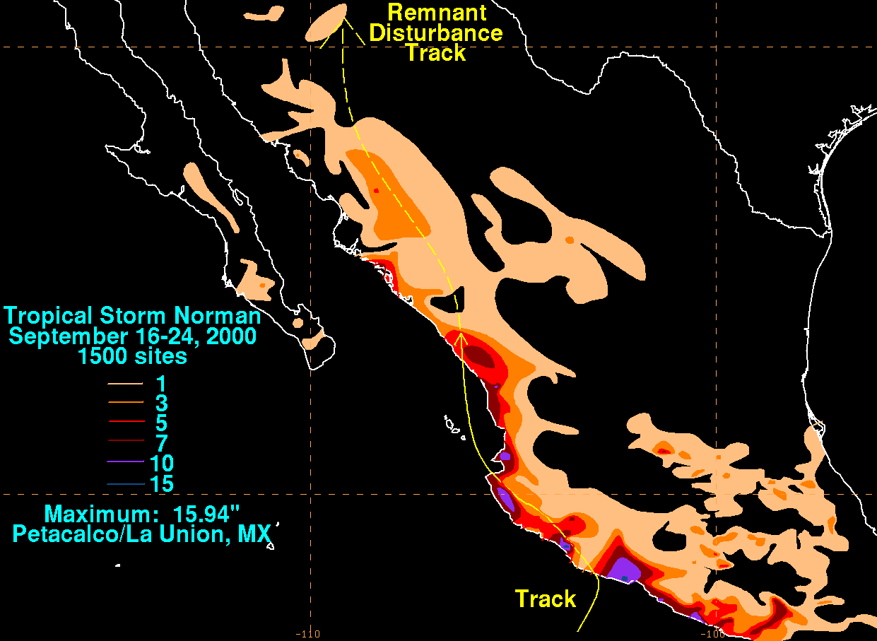
September 2000: Moisture from Tropical Storm Norman produced light rainfall across the peninsula.[67]
September 15–17, 2000: The outer rainbands of Tropical Storm Miriam brought 7.68in (195mm) at Los Cobos.[68] Throughout the country, total damages from the storm amounted to $7.2 million (MXN; $558,000 2000 USD.[69] On October 24, a national disaster declaration was signed for areas affected by Tropical Storm Miriam in the state.[70]
September 30, 2001: Tropical Storm Juliette made landfall near San Carlos. It caused damage and heavy rainfall throughout the peninsula; Cabo San Lucas was "clobbered," with it being cut off from the rest of Mexico for several days. Juliette caused two deaths in or near the peninsula.[71] A maximum of 39.8in (1,010mm) fell in Caudaño,[72] the highest known total ever recorded from a tropical cyclone in the state.[73]
September 19, 2002: Tropical Storm Iselle briefly threatened Baja California on September 19 before dissipating about 55mi (90km) offshore the next day.[74]
August 25, 2003: Hurricane Ignacio made landfall on the peninsula. Heavy rains caused a flood that swept two rescue workers to their deaths.[75]
September 22, 2003: Hurricane Marty made landfall near San Jose del Cabo. A total of 4000 houses were destroyed with disruption to boats in the area.[76] The hurricane was responsible for significant flooding and storm surges,[77] Five deaths were reported and[76] 6,000 people were affected. Total damage from the storm was $100 million.[78]
September 2, 2006: Hurricane John made landfall on the peninsula. Winds and rain caused heavy damage throughout the peninsula. John killed five people.[88] Damage in Mexico amounted to $663million (2006MXN, $60.8million 2006USD).[89]
October 23–25, 2006: Tropical Storm Paul passed close to the peninsula. High surf caused two deaths.[90]
July 2007: As a weakening tropical storm, Tropical Storm Dalila produced rough seas and heavy rains over parts of Baja California Sur.[91]
September 2007: Hurricane Henriette caused a person to drown in the surf on the south of the peninsula.[92] Henriette made landfall just east of Cabo San Lucas with winds of 80mph (130km/h).[93]
September 2007: The remnants of Hurricane Ivo produced rain without any major impact.[79][80]
August 25, 2008: Tropical Storm Julio made landfall on the peninsula, causing flooding that killed one person.[94]
October 11, 2008: Hurricane Norbert became the strongest hurricane to hit the western side of the Peninsula. Two towns were nearly completely damaged, with heavy flooding and storm surges reported.[96] The worst damage occurred in the municipality of Comondú, where 16,000 residents reported damage to their homes.[97]
September 2, 2009: Hurricane Jimena tied Norbert's short-lived record as one of the most intense hurricanes to make landfall on the Pacific side of the peninsula.[98] Before the arrival of Jimena, civil defense authorities in Los Cabos announced that they would have to evacuate 20,000 families from their homes.[99] The storm later caused widespread flooding and damage and killed one person.[98] Damage from the storm amounted to MXN$800 million (US$59.8 million).[100] A total of 35,000 were reported to have been left homeless.[101]
September 28, 2012: Tropical Storm Norman brought extremely heavy rains to the southern portion of the peninsula.[114] At least 24 cars were swept away.[115]
October 15–18, 2012: Hurricane Paul approached the region as a major hurricane.[1] Paul brought landslides and flooding to the Baja California Peninsula.[116] Damage to roads was estimated at MX$200million (US$15.5million). Approximately 580 families reported property damage caused by Hurricane Paul; many homes across the region were left without electricity and running water.[117]
September 13, 2014: Hurricane Odile was the most intense tropical cyclone to make landfall over the Baja California Peninsula in the satellite era. The storm caused five deaths on Baja, and ten deaths were recorded elsewhere. Damages were around MX$16.6billion (US$1.22billion).[118]
September 6, 2016: Hurricane Newton brought very heavy rains and winds of 90mph (150km/h) to the southern areas of the peninsula.[119]
September 2, 2017: Tropical Storm Lidia makes landfall near Punta Marquez. Severe flooding is reported and at least seven people are killed.[120]
June 14–15, 2018: Hurricane Bud hit the Baja California Peninsula as a tropical storm.[121]
September 19–20, 2018: Tropical Depression Nineteen-E formed in the Gulf of California caused heavy rains before it dissipated the next day over the mountainous terrain of Sonora.[122]
October 1–2, 2018: Hurricane Rosa weakened to a tropical depression as it made landfall in the Baja California Peninsula.[123]
October 12, 2018: Hurricane Sergio made landfall in Baja California Sur as a tropical storm before quickly weakening due to land interaction.[124]
September 8, 2022: Hurricane Kay made landfall along the Vizcaíno Peninsula with 75mph (120km/h) winds,[130] then weakened to a tropical storm, before moving back over the ocean.[131]
September 15, 2025: The outer rain bands from Tropical Storm Mario bring heavy rain to San Ignacio. A man is fatally electrocuted during the storm's passage.[139]
October 8, 2025: Hurricane Priscilla brings heavy rain and strong winds to parts of Baja California Sur as it weakened offshore. Flooding, fallen trees, and power outages were reported.[140]
October 12, 2025: Tropical Storm Raymond degenerates to a remnant low just south of the peninsula. Heavy rainfall caused flooding and sinkholes.[141]
Listed by month
Most tropical cyclone impacts occurred in the month of September. This coincides with the statistical peak in the eastern north Pacific hurricane season, which occurs in early September or late August.[142] Although hurricane season in the eastern north Pacific officially runs from May 15 to November 30,[143] no known tropical cyclones have impacted the peninsula in May, November, or outside the season except Hurricane Blanca in May 2015.
Number of recorded storms affecting the Baja California peninsula, by month of year
Month
Number of storms
January
0
February
0
March
0
April
0
May
0
June
3
July
10
August
19
September
56
October
22
November
0
December
0
Deadly systems
As many tropical cyclones impact the peninsula, sometimes when rather intense, deaths frequently occur.
If a tropical cyclone threatens to bring tropical storm or hurricane conditions to areas in the Baja California Peninsula, the government issues tropical cyclone warnings and watches for the threatened areas. The watches and warnings will be issued in coastal area between internationally recognized points known as breakpoints. The Baja California Peninsula has twenty-two breakpoints, running from the United States-Mexico border, south along the Pacific coast to Cabo San Lucas, and north along the Gulf of California coast to Calamajue.[144] However, tropical cyclones can still bring dangerous conditions such as flooding to areas not covered by warnings and watches.
↑Haydee Ramirez (October 2012). "Paul damage report" (in Spanish). Terra Mexico. Archived from the original on July 14, 2014. Retrieved October 21, 2012.
↑Daniel P. Brown (September 15, 2014). Hurricane Odile Discussion Number 21. National Hurricane Center (Report). Miami, Florida: National Oceanic and Atmospheric Administration. Retrieved September 15, 2014.
↑John P. Cangialosi; Andrew Latto (June 14, 2018). Tropical Storm Bud Advisory Number 22 (Report). Miami, Florida: National Hurricane Center. Retrieved October 3, 2018.
↑Brown, Daniel (October 2, 2018). Tropical Depression Rosa Discussion Number 29. National Hurricane Center (Report). National Oceanic and Atmospheric Administration. Retrieved October 3, 2018.
↑Avila, Lixion (October 12, 2018). Tropical Storm Sergio Discussion Number 53. National Hurricane Center (Report). National Oceanic and Atmospheric Administration. Retrieved October 14, 2018.
↑Papin, Philippe; Beven, Jack (September 9, 2021). Hurricane Olaf Discussion Number 10 (Report). Miami, Florida: National Hurricane Center. Retrieved September 11, 2021.
↑Papin, Philippe; Beven, Jack (September 9, 2021). Hurricane Olaf Tropical Cyclone Update (Report). Miami, Florida: National Hurricane Center. Retrieved September 10, 2021.
This page is based on this Wikipedia article Text is available under the CC BY-SA 4.0 license; additional terms may apply. Images, videos and audio are available under their respective licenses.


