
The 2003 Pacific hurricane season was the first season to feature no major hurricanes since 1977. The season officially began on May 15, 2003 in the Eastern North Pacific, and on June 1 in the Central ; both ended on November 30. These dates, adopted by convention, historically describe the period in each year when most tropical cyclogenesis occurs in these regions of the Pacific. The season featured 16 tropical storms, 7 of which intensified into hurricanes, which was then considered an average season. Damage across the basin reached US$129 million, and 23 people were killed by the storms.

Hurricane Javier was a powerful tropical cyclone whose remnants brought above-average rainfall totals across the western United States in September 2004. Javier was the tenth named storm, the sixth hurricane and the final major hurricane of the 2004 Pacific hurricane season. Javier was also the strongest hurricane of the 2004 season, with 150 mph (240 km/h) winds and a central pressure of 930 millibars. However, because of high wind shear in the East Pacific, Javier weakened rapidly before making landfall in Baja California as a tropical depression. The remnants of the storm then continued moving northeast through the Southwestern United States. Javier caused no direct fatalities, and the damage in Mexico and the United States was minimal.

The 2008 Pacific hurricane season was a near-average Pacific hurricane season which featured seventeen named storms, though most were rather weak and short-lived. Only seven storms became hurricanes, of which two intensified into major hurricanes. This season was also the first since 1996 to have no cyclones cross into the central Pacific. The season officially began on May 15 in the eastern Pacific and on June 1 in the central Pacific. It ended in both regions on November 30. These dates, adopted by convention, historically describe the period in each year when most tropical cyclone formation occurs in these regions of the Pacific. This season, the first system, Tropical Storm Alma, formed on May 29, and the last, Tropical Storm Polo, dissipated on November 5.

Hurricane Greg was the only eastern Pacific tropical cyclone in 1999 to make a direct landfall. Part of the annual hurricane season, Greg originated from a tropical wave that departed Africa in mid-August. The wave entered the eastern Pacific by September 1, steadily organizing over subsequent days to become a tropical depression on September 5. Amid a favorable environment, the cyclone intensified into Tropical Storm Greg a few hours after formation and further organized into a Category 1 hurricane on September 6. Greg paralleled the southwestern coastline of Mexico, where it destroyed over 250 homes, cut-off roads, killed 10 people, and left at least 4,000 more injured. The storm weakened to tropical storm intensity as it moved ashore Baja California Sur, although rain was generally beneficial there. Succumbing to cooler waters and high wind shear, Greg ultimately dissipated over the Pacific on September 9. Its remnants led to thunderstorms across northern California, with only minor impacts.

The 2013 Pacific hurricane season was an above average Pacific hurricane season with 21 tropical cyclones forming. Of these, 20 became named storms – 18 in the Eastern Pacific basin, and 2 in the Central Pacific basin. Of the 18 named storms in the east, 9 became hurricanes, with one, Raymond, becoming the season's only major hurricane. In the central, neither named storm became a hurricane. It was also a below-normal season in terms of Accumulated cyclone energy (ACE), as many of its systems were weak and short-lived. The season officially began on May 15 in the Eastern Pacific and started on June 1 in the Central Pacific; both ended on November 30. These dates conventionally delimit the period of each year when most tropical development occurs in these North Pacific basins. The first cyclone, Tropical Storm Alvin, formed on May 15, and the last, Tropical Storm Sonia, dissipated on November 4. It was below average only Category 3 storm was since 1981.

The 2017 Pacific hurricane season was an above average Pacific hurricane season in terms of named storms, though less active than the previous three, featuring eighteen named storms, nine hurricanes, and four major hurricanes. Despite the considerable amount of activity, most of the storms were weak and short-lived. The season officially started on May 15 in the eastern Pacific Ocean, and on June 1 in the central Pacific; they both ended on November 30. These dates conventionally delimit the period of each year when most tropical cyclones form in the respective regions. However, the formation of tropical cyclones is possible at any time of the year, as illustrated in 2017 by the formation of the season's first named storm, Tropical Storm Adrian, on May 9. At the time, this was the earliest formation of a tropical storm on record in the eastern Pacific basin proper. The season saw near-average activity in terms of accumulated cyclone energy (ACE), in stark contrast to the extremely active seasons in 2014, 2015, and 2016; and for the first time since 2012, no tropical cyclones formed in the Central Pacific basin. However, for the third year in a row, the season featured above-average activity in July, with the ACE value being the fifth highest for the month. Damage across the basin reached $375.28 million (2017 USD), while 45 people were killed by the various storms.
The 2013 Pacific hurricane season was an above-average year in which twenty named storms developed. The hurricane season officially began on May 15 in the East Pacific, coinciding with the formation of Tropical Storm Alvin, and on June 1 in the Central Pacific; it ended on November 30 in both basins. These dates conventionally delimit the period during each year when most tropical cyclones form. The final system of the year, Tropical Storm Sonia, dissipated on November 4.

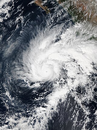
Hurricane Blanca was the earliest recorded tropical cyclone in the calendar year to make landfall on the Baja California Peninsula. Forming as the second named storm, hurricane, and major hurricane of the annual hurricane season, the system first developed into a tropical depression on May 31. The storm initially struggled to organize due to strong wind shear, but once this abated, the system took advantage of high sea surface temperatures and ample moisture. After becoming a tropical storm on June 1, Blanca rapidly intensified on June 2–3, becoming a powerful Category 4 hurricane on the Saffir–Simpson hurricane wind scale; maximum sustained winds reached 145 mph (230 km/h) at this time. The hurricane's slow motion resulted in tremendous upwelling of cooler water, resulting in a period of weakening. Blanca gradually recovered from this and briefly regained Category 4 status on June 6 as it moved generally northwest toward the Baja California peninsula. Cooler waters and increased shear again prompted weakening on June 7 and the system struck Baja California Sur on June 8 as a weak tropical storm. It quickly degraded to a depression and dissipated early the next day.
Hurricane Sandra was the latest-forming major hurricane in the northeastern Pacific basin, the strongest Pacific hurricane on record in November, and the record eleventh major hurricane of the 2015 Pacific hurricane season. Originating from a tropical wave, Sandra was first classified as a tropical depression on November 23 well south of Mexico. Environmental conditions, including high sea surface temperatures and low wind shear, were highly conducive to intensification and the storm quickly organized. A small central dense overcast developed atop the storm and Sandra reached hurricane status early on November 25 after the consolidation of an eye. Sandra reached its peak intensity as a Category 4 hurricane on the Saffir–Simpson hurricane wind scale with winds of 150 mph (240 km/h) and a pressure of 934 mbar early on November 26. Thereafter, increasing shear degraded the hurricane's structure and weakening ensued. Rapid weakening took place on November 27 and Sandra's circulation became devoid of convection as it diminished to a tropical storm that evening. The cyclone degenerated into a remnant low soon thereafter and ultimately dissipated just off the coast of Sinaloa, Mexico, on November 29.

Tropical Storm Lidia was a large tropical cyclone that caused flooding in Baja California Peninsula and parts of western Mexico. The fourteenth tropical cyclone and twelfth named storm of the 2017 Pacific hurricane season, Lidia developed from a large area of disturbed weather west of the Pacific Coast of Mexico on August 31. The storm intensified while moving generally northward or northwestward, peaking with maximum sustained winds of 65 mph (105 km/h) later that day. On September 1, Lidia made landfall in Mexico near Puerto Chale, Baja California Sur, at peak intensity. The storm weakened while traversing the peninsula, ultimately emerging over the Pacific Ocean on September 3, where the storm degenerated into a remnant low. The system brought thunderstorms and wind gusts to Southern California, before dissipating on September 4.

The 2020 Pacific hurricane season was a near average Pacific hurricane season in terms of named storms, featuring 17, but well below average season for hurricanes and major hurricanes, with only 4 hurricanes and 3 major hurricanes forming. Additionally, no tropical cyclones formed in the Central Pacific basin for the first time since 2017. The season officially began on May 15 in the East Pacific Ocean, and on June 1 in the Central Pacific (from 140°W to the International Date Line, north of the equator; they both ended on November 30. These dates conventionally delimit the period of each year when most tropical cyclones form in the respective regions. However, the formation of tropical cyclones is possible at any time of the year, as illustrated in 2020 by the formation of the season's first system, Tropical Depression One-E, on April 25. This was the earliest formation of a tropical cyclone on record in the eastern Pacific basin proper. The final system of the season was Tropical Storm Polo, which dissipated on November 19.
The 2021 Pacific hurricane season was a moderately active Pacific hurricane season, with above-average activity in terms of number of named storms, but below-average activity in terms of major hurricanes, as 19 named storms, 8 hurricanes, and 2 major hurricanes formed in all. It also had a near-normal accumulated cyclone energy (ACE). The season officially began on May 15, 2021 in the Eastern Pacific Ocean, and on June 1, 2021, in the Central Pacific in the Northern Hemisphere. The season ended in both regions on November 30, 2021. These dates historically describe the period each year when most tropical cyclogenesis occurs in these regions of the Pacific and are adopted by convention. However, the formation of tropical cyclones is possible at any time of the year, as illustrated by the formation of Tropical Storm Andres on May 9, which was the earliest forming tropical storm on record in the Eastern Pacific. Conversely, 2021 was the second consecutive season in which no tropical cyclones formed in the Central Pacific.

The 2022 Pacific hurricane season was a slightly above average hurricane season in the eastern North Pacific basin, with nineteen named storms, ten hurricanes, and four major hurricanes. Two of the storms crossed into the basin from the Atlantic. In the central North Pacific basin, no tropical cyclones formed. The season officially began on May 15 in the eastern Pacific, and on June 1 in the central; both ended on November 30. These dates historically describe the period each year when most tropical cyclogenesis occurs in these regions of the Pacific and are adopted by convention.

Tropical Storm Narda was a short-lived tropical storm that remained close to the Pacific coast of Mexico, causing flash flooding and mudslides in southwestern Mexico and the Baja California Peninsula in late September 2019. The fourteenth named storm of the 2019 Pacific hurricane season, Narda developed from a broad area of low pressure that formed off the Central American Pacific coast on September 26. The broad low gradually organized as it moved west-northwestward, and it became Tropical Storm Narda early on September 29 while located off the southern coast of Mexico. The cyclone strengthened slightly before it moved inland near Manzanillo. Narda weakened to a tropical depression after moving inland, but restrengthened into a tropical storm on September 30 as it emerged over the Pacific Ocean just south of the Gulf of California. Narda quickly strengthened, and reached its peak intensity with winds of 50 mph (85 km/h) that day before making a second landfall along the northwestern coast of Mexico. The tropical cyclone weakened rapidly as it moved along the coastline, and it weakened to a tropical depression before dissipating just off the coast of Sonora on October 1.

Hurricane Genevieve was a strong tropical cyclone that almost made landfall on the Baja California Peninsula in August 2020. Genevieve was the twelfth tropical cyclone, seventh named storm, third hurricane, and second major hurricane of the 2020 Pacific hurricane season. The cyclone formed from a tropical wave that the National Hurricane Center (NHC) first started monitoring on August 10. The wave merged with a trough of low pressure on August 13, and favorable conditions allowed the wave to intensify into Tropical Depression Twelve-E at 15:00 UTC. Just six hours later, the depression became a tropical storm and was given the name Genevieve. Genevieve quickly became a hurricane by August 17, and Genevieve began explosive intensification the next day. By 12:00 UTC on August 18, Genevieve reached its peak intensity as a Category 4 hurricane, with maximum 1-minute sustained winds of 130 mph and a minimum central pressure of 950 millibars (28 inHg). Genevieve began to weaken on the next day, possibly due to cooler waters caused by Hurricane Elida earlier that month. Genevieve weakened below tropical storm status around 18:00 UTC on August 20, as it passed close to Baja California Sur. Soon afterward, Genevieve began to lose its deep convection and became a post-tropical cyclone by 21:00 UTC on August 21, eventually dissipating off the coast of Southern California late on August 24.

The 2023 Pacific hurricane season was an active and destructive Pacific hurricane season. In the Eastern Pacific basin, 17 named storms formed; 10 of those became hurricanes, of which 8 strengthened into major hurricanes – double the seasonal average. In the Central Pacific basin, no tropical cyclones formed for the fourth consecutive season, though four entered into the basin from the east. Collectively, the season had an above-normal accumulated cyclone energy (ACE) value of approximately 168 units. This season saw the return of El Niño and its associated warmer sea surface temperatures in the basin, which fueled the rapid intensification of several powerful storms. It officially began on May 15, 2023 in the Eastern Pacific, and on June 1 in the Central; both ended on November 30. These dates, adopted by convention, historically describe the period in each year when most tropical cyclogenesis occurs in these regions of the Pacific.

The 2021 Pacific hurricane season was a moderately active hurricane season, with above-average tropical activity in terms of named storms, but featured below-average activity in terms of major hurricanes. It is the first season to have at least five systems make landfall in Mexico, the most since 2018. It was also the second consecutive season in which no tropical cyclones formed in the Central Pacific. The season officially began on May 15 in the Eastern Pacific, and on June 1 in the Central Pacific; both ended on November 30. These dates historically describe the period each year when most tropical cyclones form in the eastern and central Pacific and are adopted by convention. However, the formation of tropical cyclones is possible at any time of the year, as illustrated this year by the formation of Tropical Storm Andres on May 9. This was the earliest forming tropical storm on record in the Eastern Pacific. The season effectively ended with the dissipation of Tropical Storm Terry, on November 10.

Hurricane Enrique was a Category 1 Pacific hurricane that brought heavy rainfall and flooding to much of western Mexico in late June 2021. The fifth named storm and first hurricane of the 2021 Pacific hurricane season, Enrique developed from a tropical wave the entered the Pacific Ocean off the coast of Nicaragua on June 22. In an environment conducive for intensification, the disturbance moved west-northwestward and developed into a tropical storm by 6:00 UTC on June 25, as it was already producing winds of 40 mph (65 km/h), and received the name Enrique. Enrique strengthened steadily within an environment of warm waters and low-to-moderate wind shear while continuing its northwestward motion. By 12:00 UTC on June 26, Enrique had intensified into a Category 1 hurricane as the storm turned more northwestward. Nearing the coast of Mexico, Enrique reached its peak intensity around 6:00 UTC the following day, with maximum sustained winds of 90 mph (150 km/h) and a minimum barometric pressure of 972 mbar (28.7 inHg). Enrique, passing closely offshore west-central Mexico, maintained its intensity for another 24 hours as it turned northward toward the Gulf of California. Turning back to the northwest on June 28, increasing wind shear and dry air caused the hurricane to weaken. Enrique dropped to tropical storm status at 18:00 UTC that day, and further weakened to a tropical depression on June 30 just to the northeast of Baja California. The depression was absorbed into a larger low pressure area to the southeast later that day.

Hurricane Nora was a large tropical cyclone that caused significant damage across the Pacific Coast of Mexico in late August 2021. The fourteenth named storm and fifth hurricane of the 2021 Pacific hurricane season, Nora was first monitored by the National Hurricane Center (NHC) as an area of low pressure near the coast of Mexico. On August 24, the low organized into tropical depression, but struggled to develop further due to wind shear in its surrounding environment. The depression eventually intensified into a tropical storm and was named Nora as it tracked to the west-northwest. Nora peaked as a strong Category 1 hurricane with maximum sustained winds of 85 miles per hour (140 km/h) on August 28. The storm then grazed the west coast of Mexico and made landfall two separate times, first in the state of Jalisco, followed by neighboring Nayarit. Nora weakened as it interacted with land, dissipating on August 30 just inland of the Mexican coast.


