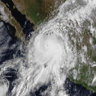
Hurricane Pamela

Last updated

Map key
  Tropical depression (≤38 mph, ≤62 km/h)
  Tropical storm (39–73 mph, 63–118 km/h)
  Category 1 (74–95 mph, 119–153 km/h)
  Category 2 (96–110 mph, 154–177 km/h)
  Category 3 (111–129 mph, 178–208 km/h)
  Category 4 (130–156 mph, 209–251 km/h)
  Category 5 (≥157 mph, ≥252 km/h)
  Unknown
Storm type
Disc Plain black.svg Tropical cyclone
Solid black.svg Subtropical cyclone
ArrowUp.svg Extratropical cyclone, remnant low, tropical disturbance, or monsoon depression

On October 7 at 06:00 UTC, the National Hurricane Center (NHC) began to monitor a tropical wave, along with its disorganized showers and thunderstorms centered over the southwestern Caribbean Sea, or near Nicaragua for possible tropical cyclogenesis in the Eastern Pacific basin. [1] The aforementioned disturbance crossed the country and nearby Costa Rica, emerging over the Pacific on the next day. [2] The system subsequently took a westward track and on 00:00 UTC on October 9, a broad area of low pressure developed from the wave. However, its convection remained disorganized until it became better organized on the next day. [3] [4]

Tropical Storm Pamela on October 11 taken from the red visible band onboard GOES-17. Pamela 2021-10-11 1950Z.jpg
Tropical Storm Pamela on October 11 taken from the red visible band onboard GOES-17.

A 02:57 UTC ASCAT pass on that day revealed a developing closed circulation on the system. With the additional scatterometer data retrieved from the disturbance and Dvorak ratings of T2.0, along with its increasing convection, the NHC started initiating its first advisory on Tropical Depression Sixteen-E, the first active tropical cyclone in the basin in nearly a month. [5] Later, cloud tops colder than -80 °C sprawling onto the new depression, initiating a west-northwestward motion, the system was located over an area conductive for further development. [6] that night, convection got further concentrated into its low level circulation center (LLCC), although it became partially exposed due to northeasterly wind shear. However, gale-force winds were detected by a scatterometer pass in its northeastern quadrant and as a result, the NHC upgraded the depression to a tropical storm, assigning it the name “Pamela” on 21:00 UTC. [7] Despite the shear and dry air, Pamela continued to intensify near hurricane status on the next day and becoming a fully-fledged Category 1 system, twelve hours later while turning northwards. [8] [9] Pamela underwent a convective bursting phase at this time, and it continued intensifying slowly to its first peak of 70 knots (130 km/h; 81 mph) regardless of wind shear disrupting its outflow layer before weakening to a high-end tropical storm at 21:00 UTC on October 12, based on the data retrieved from an Air Force reconnaissance aircraft that investigated the system that day. [10] [11] By the next day, Pamela turned to the north-northeast and maintained its tropical storm intensity before reintensifying to a low-end Category 1 hurricane once again as the system neared the coast of Mexico on 09:00 UTC on October 13. [12] [13]

Three hours later, Pamela made landfall over Estacion Dimas, Sinaloa with winds of 75 mph, [14] soon after it was downgraded to a tropical storm at 15:00 UTC while located inland. [15] Rapid weakening further took toll on Pamela while accelerating across the rugged terrains of Mexico, with the system weakening to a tropical depression, six hours later, the NHC issued its final advisory as the agency declared the system to have dissipated on 03:00 UTC on October 14 while over Coahuila. [16] [17]

Preparations

The Government of Mexico issued tropical cyclone watches across the affected areas of Mexico, starting on 15:00 UTC on October 11 and ended as Pamela weakened to a tropical depression inland. [18] [19] The Comisión Nacional del Agua (National Water Commission) also issued an alert for the Mexican state of Sinaloa due to the possible threat of Pamela. The storm was also anticipated to bring heavy rainfall with possible landslides, strong winds, rough seas and a possible increase in water levels of streams and rivers throughout the coastal and inland areas of Baja California Sur, Sinaloa, Durango and Nayarit, according to the Servicio Meteorológico Nacional. [20] [21] The former's State Council of Civil Protection also declared the state itself in an alert due to Pamela's approach. The Cabo San Lucas' port was closed to all boats while 8 safety shelters in La Paz and 11 in Cabo San Lucas were opened in case of possible evacuation. The Comisión Federal de Electricidad (CFE) also sent some of its people on the latter to fix possible electrical problems. [22] The government of Sinaloa put 10 of its southern municipalities in red alert due to the threat of the storm while 13 flights were canceled by the General Rafael Buelna International Airport for October 13. 40 shelters were opened for possible heavy rains and strong winds. The Civil Protection in Mazatlán also noted that over 80 areas in the state were in risk of possible flooding, with 23 people going to safety shelters to ride out the storm. [23] [24]

Impact

Mexico

The passage of the outer bands of Pamela caused flooding in Colima. In Manzanillo, these inundations caused several towns to be cut off. A stream on Colimilla overflowed due to heavy rains, resulting in people in the place crossing by boat to go through the nearby Barra de Navidad, Jalisco. On October 11 in that morning, a hotel worker in Colima tried to cross a stream, but was unsuccessful as the person were already swept away by the current; however, they managed to escape the accident without being harmed. The road connecting the Ejido el Huizcolote with Camotlán collapsed due to the storm; the thoroughfare were already previously damaged because of rainfall. Several highways also sustained damages throughout Manzanillo and Colima due to various reasons. [25] Rainfall from the storm also flooded central areas of Tecuala, Nayarit. This made passengers and motorists wade the swamped roadways. Other municipalities to its north were also affected by torrential downpours. The waters of the river that passes through Huajicori was reported to have been rising due to the amount of rainfall being collected along the mountainous areas of Durango and Zacatecas, forcing the passage through Quiviquinta, a town over Nayarit to be temporarily closed. [26] 4 people were also missing in Nayarit, including three public officials and two residents of the Huajicori Riverbed. [27] In the municipalities of Acaponeta, Tecuala and Tuxpan, there were floods with water reaching 5 meters high. [28]

Several palm trees were swaying in the wind brought by Pamela in Sinaloa while a bank lost its windows, authorities there reported. Many trees were also uprooted by the storm in Mazatlan. Shops and restaurants in the beach resort area also sustained damages due to the system. The Mexican National Guard informed Reuters that their people performed rescues in people whose trapped in their homes as a result of flooding. [24] Many palapas in Isla de la Piedra were destroyed as a result of the storm's strong winds. [29] Landslides also affected a part of the Mazatlán-Durango tollway and the libre (free highway) between the same cities. However, Mazatlan authorities reported only minor damages from Pamela, the worst being the flooding in several neighborhoods of the area. [30] 141.0 millimetres (5.55 in) of rain were recorded in the area, according to the Comité Local de Atención a Emergencias (CLAE). [31] Meanwhile, the Comisión Federal de Electricidad (CFE) restored 57% of power that was cut during Pamela's passage on October 13. Over 195,990 customers were affected overall. Over 10,732 lost their electricity in the state of Nayarit, 173,191 in Sinaloa, 9,887 in Durango and 2,980 in Coahuila. [32]

The Acaponeta River in Nayarit overflowed their banks, which resulted in the inundation of several nearby towns. Individuals near the area were also forced to climb onto their cars and wait for help or seek shelter in higher ground. The Tepic-Mazatlán highway was also included in the affected areas by the overflowing of the said river, in which two people were trapped in the Tecuala toll booth, with one person being swept away and the other being rescued. [33] The subdivision of Urbi Villa del Rey in Los Mochis was also inundated by the storm's rainfall, although public transportation was not affected. As the Baluarte River also overflowed, the municipality of Rosario in Sinaloa promptly evacuated more than 1,500 families in 6 communities in the area. Authorities there also described the damages in the area as "catastrophic". [34] [35] Tecuala, Nayarit was also reported by the authorities as inaccessible, due to rains generated by Pamela, causing a large sinkhole in Acaponeta-Tecuala road. [36] 7.648 hectares (18.90 acres) of cropland were also damaged in Sinaloa, in which the chili pepper industry suffered the most. [37] Over 9,106 people were affected in Nayarit and 8,000 of them early lost their homes. [38] Despite the disaster, the rains brought by Pamela were reported as "beneficial" on Carrizo Valley as crops there are still growing and they are mostly needed. [39] Damages from the storm were estimated at over 1.94 billion pesos (US$97 million) in Mexico, [40] almost all of which occurred in Sinaloa. [41]

Southern United States

Despite dissipating over the mountainous terrain of Mexico, Pamela's remnant moisture moved into Texas, where two individuals were killed after they were swept into a creek in Bexar County. Five other individuals were rescued from two vehicles. Heavy rainfall also affected San Antonio, with 3.5 inches (89 mm) being recorded there, and 7 inches (180 mm) recorded in Gonzales County. Multiple water rescues were also carried out in the state, due to the storm. [42] [43]

See also

Related Research Articles

<span class="mw-page-title-main">Hurricane Madeline (1998)</span> Category 1 Pacific hurricane in 1998

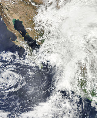
Hurricane Madeline was a costly tropical cyclone whose remnants caused hundreds of millions of dollars in damage in Texas in October 1998. The final tropical cyclone of the 1998 Pacific hurricane season, Madeline originated from a tropical wave that emerged off the coast of Africa on September 25, 1998. The wave traversed the Atlantic Ocean and crossed over Central America on October 5 or 6. Gradually, the system intensified and was classified as a tropical depression on October 16, a tropical storm later that day, and a hurricane on October 17. The storm reached peak winds of 85 mph (137 km/h) about 95 miles (153 km) southwest of San Blas, Nayarit, and after 18 hours it subsequently began to weaken. Although Madeline never made landfall, numerous rainbands affected the Mexican coast causing no known damage or fatalities. The remnant moisture moved north and contributed to flooding in central Texas, which killed 31 people and caused $750 million in damage.
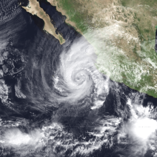
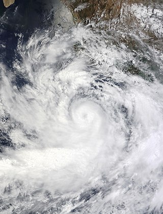
<span class="mw-page-title-main">Tropical Depression One-E (2009)</span> Pacific tropical depression in 2009

Tropical Depression One-E was the earliest tropical cyclone in the calendar year to impact the Mexican state of Sinaloa ever recorded. The first system of the 2009 Pacific hurricane season, One-E formed out of an area of disturbed weather on June 18, 2009, and initially tracked slowly northwards. Throughout the day, convection developed around the center of circulation and the system was anticipated to become a tropical storm. Late on June 18, the National Hurricane Center noted that the system was on the verge of becoming a tropical storm; it would have been named Andres had this occurred. However, the following day, strong wind shear caused the depression to rapidly degenerate into a trough of low pressure before dissipating off the coast of Sinaloa.

<span class="mw-page-title-main">2013 Pacific hurricane season</span>

The 2013 Pacific hurricane season was an above average Pacific hurricane season with 21 tropical cyclones forming. Of these, 20 became named storms – 18 in the Eastern Pacific basin, and 2 in the Central Pacific basin. Of the 18 named storms in the east, 9 became hurricanes, with one, Raymond, becoming the season's only major hurricane. In the central, neither named storm became a hurricane. It was also a below-normal season in terms of Accumulated cyclone energy (ACE), as many of its systems were weak and short-lived. The season officially began on May 15 in the Eastern Pacific and started on June 1 in the Central Pacific; both ended on November 30. These dates conventionally delimit the period of each year when most tropical development occurs in these North Pacific basins. The first cyclone, Tropical Storm Alvin, formed on May 15, and the last, Tropical Storm Sonia, dissipated on November 4.

<span class="mw-page-title-main">Tropical Storm Norman (2012)</span> Pacific tropical storm in 2012

Tropical Storm Norman was the fourteenth tropical cyclone of the 2012 Pacific hurricane season that brought minor flooding to western Mexico and record rainfall to areas of Texas in September 2012. Originating from a disturbance near the southern tip of Baja California, it soon moved north and developed into a tropical cyclone on September 28. Upon developing into one, Norman attained its peak intensity with maximum sustained winds of 50 mph (85 km/h). Heading northward into the Gulf of California, the storm began to weaken later that day due to southwesterly wind shear and land interaction. Norman curved northwestward and weakened to a tropical depression early on September 29. Around that time, it briefly moved inland near Topolobampo, Sinaloa, before re-emerging into the Gulf of California. Later on September 29, Norman degenerated into a remnant low pressure area.
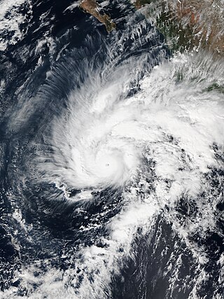
<span class="mw-page-title-main">Hurricane Erick (2013)</span> Category 1 Pacific hurricane in 2013

Hurricane Erick brought minor impacts to the western coastline of Mexico in July 2013, and was the last of a succession of four Category 1 hurricanes to affect the Pacific coast of Mexico early in the 2013 Pacific hurricane season. The fifth named storm and fourth hurricane of the annual season, Erick originated from a tropical wave that moved off the western coast of Africa on June 18. The wave tracked swiftly westward with little development, emerging into the eastern Pacific on July 1. As a result of favorable environmental conditions, the wave developed into a tropical depression on July 4, and further into Tropical Storm Erick at 0000 UTC on July 5. Steered generally west-northwest, Erick intensified into a Category 1 hurricane and reached its peak intensity with winds of 80 mph (130 km/h) on July 6. Its proximity to land and track over increasingly cooler waters caused the storm to deteriorate into a tropical storm the following day, though it remained at such intensity until degenerating into a remnant low early on July 9. The remnant circulation dissipated a few hours later, southwest of Baja California Sur.

<span class="mw-page-title-main">Hurricane Norbert (2014)</span> Category 3 Pacific hurricane in 2014

Hurricane Norbert produced a 1-in-1,000 year rainfall event in Arizona in early September 2014. The fifteenth named storm, tenth hurricane, and seventh major hurricane of the 2014 Pacific hurricane season, Norbert originated from an area of disturbed weather in association with an area of low pressure on September 2. Tracking generally northwestward, the newly designated tropical storm steadily organized in a moderate shear environment. Norbert attained hurricane intensity early on September 4 and Category 2 hurricane strength the next afternoon. Thereafter, the cyclone began a period of rapid deepening, and it subsequently attained its peak intensity with winds of 125 mph (201 km/h) and a minimum pressure of 950 mbar early on September 6. A track over progressively cooler waters and into a more stable environment prompted a weakening trend after peak intensity, and by early on September 8, the system no longer maintained enough convection to be considered a tropical cyclone.

<span class="mw-page-title-main">Hurricane Sandra (2015)</span> Category 4 Pacific hurricane in 2015

Hurricane Sandra was the latest-forming major hurricane in the northeastern Pacific basin, the strongest Pacific hurricane on record in November, and the record eleventh major hurricane of the 2015 Pacific hurricane season. Originating from a tropical wave, Sandra was first classified as a tropical depression on November 23 well south of Mexico. Environmental conditions, including high sea surface temperatures and low wind shear, were highly conducive to intensification and the storm quickly organized. A small central dense overcast developed atop the storm and Sandra reached hurricane status early on November 25 after the consolidation of an eye. Sandra reached its peak intensity as a Category 4 hurricane on the Saffir–Simpson hurricane wind scale with winds of 150 mph (240 km/h) and a pressure of 934 mbar early on November 26. Thereafter, increasing shear degraded the hurricane's structure and weakening ensued. Rapid weakening took place on November 27 and Sandra's circulation became devoid of convection as it diminished to a tropical storm that evening. The cyclone degenerated into a remnant low soon thereafter and ultimately dissipated just off the coast of Sinaloa, Mexico, on November 29.

<span class="mw-page-title-main">2021 Pacific hurricane season</span>

The 2021 Pacific hurricane season was a moderately active Pacific hurricane season, with above-average activity in terms of number of named storms, but below-average activity in terms of major hurricanes, as 19 named storms, 8 hurricanes, and 2 major hurricanes formed in all. It also had a near-normal accumulated cyclone energy (ACE). The season officially began on May 15, 2021 in the Eastern Pacific Ocean, and on June 1, 2021, in the Central Pacific in the Northern Hemisphere. The season ended in both regions on November 30, 2021. These dates historically describe the period each year when most tropical cyclogenesis occurs in these regions of the Pacific and are adopted by convention. However, the formation of tropical cyclones is possible at any time of the year, as illustrated by the formation of Tropical Storm Andres on May 9, which was the earliest forming tropical storm on record in the Eastern Pacific. Conversely, 2021 was the second consecutive season in which no tropical cyclones formed in the Central Pacific.

<span class="mw-page-title-main">2022 Pacific hurricane season</span>

The 2022 Pacific hurricane season was an above average hurricane season in the eastern North Pacific basin, with nineteen named storms, ten hurricanes, and four major hurricanes. Two of the storms crossed into the basin from the Atlantic. In the central North Pacific basin, no tropical cyclones formed. The season officially began on May 15 in the eastern Pacific, and on June 1 in the central; both ended on November 30. These dates historically describe the period each year when most tropical cyclogenesis occurs in these regions of the Pacific and are adopted by convention.

<span class="mw-page-title-main">Hurricane Willa</span> Category 5 Pacific hurricane in 2018

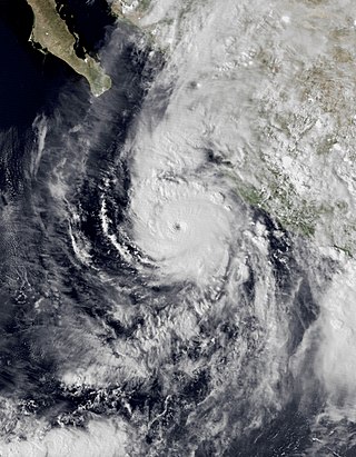
Hurricane Willa was a powerful tropical cyclone that brought torrential rains and destructive winds to southwestern Mexico, particularly the states of Sinaloa and Nayarit, during late October 2018. It was the twenty-fifth tropical cyclone, twenty-second named storm, thirteenth hurricane, tenth major hurricane, and record-tying third Category 5 hurricane of the 2018 Pacific hurricane season. Willa was the first major hurricane to make landfall in the Mexican state of Sinaloa since Lane in 2006.

<span class="mw-page-title-main">Tropical Storm Hernan (2020)</span> Eastern Pacific tropical storm in 2020

Tropical Storm Hernan was a short-lived tropical cyclone that brought widespread flooding and destructive mudslides to southwestern Mexico in late August 2020. Hernan was the thirteenth tropical cyclone and eighth named storm of the 2020 Pacific hurricane season. The system developed from a low-pressure area to the southwest of Mexico on August 26, as a low-end tropical storm. Moving generally northward and paralleling the west coast of Mexico, Hernan was hindered by a high wind shear environment and only slightly strengthened. The cyclone achieved its peak intensity around 06:00 UTC on August 27 with maximum sustained winds of 70 km/h (45 mph) and a minimum barometric pressure of 1,001 mbar (29.6 inHg). Passing just offshore of the state of Jalisco, Hernan turned west and degenerated to a remnant low on August 28. The low passed near the southern tip of the Baja California Peninsula later that day and dissipated shortly thereafter.

<span class="mw-page-title-main">Tropical Storm Dolores (2021)</span> Eastern Pacific tropical storm in 2021

Tropical Storm Dolores was a strong tropical storm that made landfall in southwestern Mexico in June 2021. The fourth named storm of the 2021 Pacific hurricane season, Dolores developed from a low-pressure area that formed offshore the Mexican state of Oaxaca on June 16, 2021. The low steadily developed organized deep convection and a closed surface circulation, becoming Tropical Depression Four-E around 06:00 UTC June 18. The depression strengthened into a tropical storm nine hours later and was named Dolores. Gradually approaching the southwestern coast of Mexico, Dolores steadily intensified despite its close proximity to land. The storm reached its peak intensity around 15:00 UTC June 19 with maximum sustained winds of 115 km/h (70 mph) and a minimum barometric pressure of 29.2 inHg (989 mbar), just below hurricane strength. Shortly after reaching this intensity, Dolores made landfall just northwest of Punta San Telmo, near the Colima–Michoacán state border. The storm rapidly weakened as it moved inland over Mexico and dissipated early on June 20 over the state of Zacatecas.

<span class="mw-page-title-main">Hurricane Enrique (2021)</span> Category 1 Pacific hurricane in 2021

Hurricane Enrique was a Category 1 Pacific hurricane that brought heavy rainfall and flooding to much of western Mexico in late June 2021. The fifth named storm and first hurricane of the 2021 Pacific hurricane season, Enrique developed from a tropical wave the entered the Pacific Ocean off the coast of Nicaragua on June 22. In an environment conducive for intensification, the disturbance moved west-northwestward and developed into a tropical storm by 6:00 UTC on June 25, as it was already producing winds of 40 mph (65 km/h), and received the name Enrique. Enrique strengthened steadily within an environment of warm waters and low-to-moderate wind shear while continuing its northwestward motion. By 12:00 UTC on June 26, Enrique had intensified into a Category 1 hurricane as the storm turned more northwestward. Nearing the coast of Mexico, Enrique reached its peak intensity around 6:00 UTC the following day, with maximum sustained winds of 90 mph (150 km/h) and a minimum barometric pressure of 972 mbar (28.7 inHg). Enrique, passing closely offshore west-central Mexico, maintained its intensity for another 24 hours as it turned northward toward the Gulf of California. Turning back to the northwest on June 28, increasing wind shear and dry air caused the hurricane to weaken. Enrique dropped to tropical storm status at 18:00 UTC that day, and further weakened to a tropical depression on June 30 just to the northeast of Baja California. The depression was absorbed into a larger low pressure area to the southeast later that day.

<span class="mw-page-title-main">Hurricane Nora (2021)</span> Category 1 Pacific hurricane in 2021

Hurricane Nora was a large tropical cyclone that caused significant damage across the Pacific Coast of Mexico in late August 2021. The fourteenth named storm and fifth hurricane of the 2021 Pacific hurricane season, Nora was first monitored by the National Hurricane Center (NHC) as an area of low pressure near the coast of Mexico. On August 24, the low organized into tropical depression, but struggled to develop further due to wind shear in its surrounding environment. The depression eventually intensified into a tropical storm and was named Nora as it tracked to the west-northwest. Nora peaked as a strong Category 1 hurricane with maximum sustained winds of 85 miles per hour (140 km/h) on August 28. The storm then grazed the west coast of Mexico and made landfall two separate times, first in the state of Jalisco, followed by neighboring Nayarit. Nora weakened as it interacted with land, dissipating on August 30 just inland of the Mexican coast.

<span class="mw-page-title-main">Hurricane Olaf (2021)</span> Category 2 Pacific hurricane in 2021

Hurricane Olaf was a Category 2 Pacific hurricane that struck the Baja California Peninsula in September 2021. The fifteenth named storm and sixth hurricane of the 2021 Pacific hurricane season, the cyclone formed from an area of low pressure that developed off the southwestern coast of Mexico on September 5, 2021. The disturbance developed within a favorable environment, acquiring more convection and a closed surface circulation. The disturbance developed into Tropical Depression Fifteen-E by 18:00 UTC on September 7. The depression strengthened into a tropical storm and was named Olaf at 12:00 UTC the next day. Olaf quickly strengthened as it moved to the north-northwest, and was upgraded to a hurricane 24 hours after being named. Hurricane Olaf continued to intensify and reached peak intensity while its center was just offshore the southwestern coast of Baja California Sur, with maximum sustained winds of 105 mph (169 km/h) and a minimum barometric pressure of 975 mbar (28.8 inHg). Just after reaching peak intensity, the hurricane made landfall near San José del Cabo. Interaction with the mountainous terrain of the Baja California Peninsula caused Olaf to quickly weaken. It was downgraded to a tropical storm at 12:00 UTC on September 10. The system became devoid of convection later that day and degenerated to a remnant low by 06:00 UTC on September 11.

<span class="mw-page-title-main">Hurricane Rick (2021)</span> Category 2 Pacific hurricane in 2021

Hurricane Rick was a Category 2 Pacific hurricane that struck the southwestern coast of Mexico in late October 2021. Rick was the overall seventeenth named system and the eighth hurricane of the 2021 Pacific hurricane season, as well as the fifth named storm and fourth hurricane to make landfall along the Pacific coast of Mexico in 2021.

<span class="mw-page-title-main">Hurricane Blas (2022)</span> Category 1 Pacific hurricane in 2022

Hurricane Blas was a Category 1 hurricane that brought winds and flooding to several Mexican states in June 2022. The second named storm and second hurricane of the 2022 Pacific hurricane season, Blas developed from a low-pressure area off the coast of southwestern Mexico. It became a tropical depression on June 14. and strengthened into a tropical storm later that same day. Blas became a hurricane the next day, while paralleling the coast. The system reached its peak intensity on June 17, at 15:00 UTC, with maximum sustained winds of 80 knots and a central pressure of 976 mbar (28.82 inHg). Later, Blas turned to the west and weakened, becoming a tropical depression on June 20, before transitioning into a post-tropical cyclone on that same day.

<span class="mw-page-title-main">Hurricane Orlene (2022)</span> Category 4 Pacific hurricane in 2022

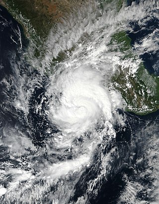
Hurricane Orlene was a powerful tropical cyclone that caused minor damage to the Pacific coast of Mexico in October 2022. The cyclone was the sixteenth named storm, ninth hurricane, and third major hurricane of the 2022 Pacific hurricane season. Orlene originated from a low-pressure area off the coast of Mexico. Moving towards the north, Orlene gradually strengthened, becoming a hurricane on October 1 and reaching its peak intensity the following day with winds of 130 mph (215 km/h). Orlene made landfall just north of the Nayarit and Sinaloa border, with winds of 85 mph (140 km/h). Soon afterward, Orlene rapidly weakened and became a tropical depression, eventually dissipating over the Sierra Madre Occidental late on October 4.

<span class="mw-page-title-main">Hurricane Roslyn (2022)</span> Category 4 Pacific hurricane in 2022

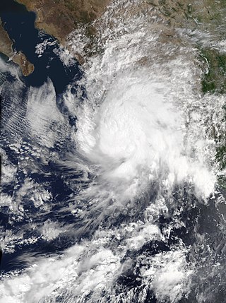
Hurricane Roslyn was a powerful tropical cyclone that struck the Pacific coast of Mexico in October 2022. The nineteenth named storm, tenth hurricane, and fourth major hurricane of the 2022 Pacific hurricane season, Roslyn formed on October 20, from an area of low pressure that developed off the southwestern coast of Mexico. The system moved west-northwestward, paralleling the coast, where it became a hurricane at 00:00 UTC, on October 22, and, within 18 hours rapidly intensified to a Category 4 hurricane, with sustained winds of 130 mph (215 km/h). Roslyn made landfall on October 23 near Santa Cruz in northern Nayarit, at 11:20 UTC with 120 mph (195 km/h) winds. Inland, Roslyn weakened quickly to a tropical storm, and then dissipated over east-central Mexico on October 24.

<span class="mw-page-title-main">Hurricane Norma (2023)</span> Category 4 Pacific hurricane in 2023

Hurricane Norma was one of four tropical cyclones to strike the Pacific Coast of Mexico in October 2023. The seventeenth tropical depression, fourteenth named storm, ninth hurricane and seventh major hurricane of the 2023 Pacific hurricane season, Norma developed from an area of low pressure that formed off the coast of southern Mexico on October 15, 2023. The disturbance gradually organized as it progressed westward parallel to the coast, and developed into Tropical Storm Norma on October 17. Turning northward, Norma rapidly intensified to a Category 4 hurricane as it continued to parallel the west coast of Mexico. Less favorable environmental conditions caused Norma to gradually weaken as it approached the Baja California peninsula. The cyclone made landfall on the Mexican state of Baja California Sur as a Category 1 hurricane. Norma continued to weaken as it crossed the state. The storm emerged over the Gulf of California on October 22, and made landfall as a tropical depression the following day on the state of Sinaloa. Norma quickly dissipated as it moved inland over Mexico.

References

  1. John Cangialosi (October 7, 2021). "Tropical Weather Outlook". Miami, Florida: National Hurricane Center . Retrieved October 11, 2021.
  2. Andrew Latto (October 8, 2021). "Tropical Weather Outlook". Miami, Florida: National Hurricane Center . Retrieved October 11, 2021.
  3. Andrew Latto (October 9, 2021). "Tropical Weather Outlook". Miami, Florida: National Hurricane Center . Retrieved October 11, 2021.
  4. Eric Blake (October 10, 2021). "Tropical Weather Outlook". Miami, Florida: National Hurricane Center . Retrieved October 11, 2021.
  5. Philippe Papin (October 10, 2021). "Tropical Depression Sixteen-E Discussion Number 1". Miami, Florida: National Hurricane Center . Retrieved October 11, 2021.
  6. Andrew Latto (October 10, 2021). "Tropical Depression Sixteen-E Discussion Number 2". Miami, Florida: National Hurricane Center . Retrieved October 11, 2021.
  7. Andrew Latto (October 10, 2021). "Tropical Storm Pamela Discussion Number 3". Miami, Florida: National Hurricane Center . Retrieved October 11, 2021.
  8. Stacy Stewart (October 11, 2021). "Tropical Storm Pamela Discussion Number 7". Miami, Florida: National Hurricane Center . Retrieved October 11, 2021.
  9. John Cangialosi (October 12, 2021). "Hurricane Pamela Discussion Number 9". Miami, Florida: National Hurricane Center . Retrieved October 11, 2021.
  10. Stacy Stewart (October 12, 2021). "Hurricane Pamela Discussion Number 10". Miami, Florida: National Hurricane Center . Retrieved October 12, 2021.
  11. Stacy Stewart (October 12, 2021). "Tropical Storm Pamela Discussion Number 11". Miami, Florida: National Hurricane Center . Retrieved October 12, 2021.
  12. Daniel Brown (October 12, 2021). "Tropical Storm Pamela Discussion Number 11". Miami, Florida: National Hurricane Center . Retrieved October 12, 2021.
  13. Richard Pasch (October 13, 2021). "Hurricane Pamela Discussion Number 13". Miami, Florida: National Hurricane Center . Retrieved October 12, 2021.
  14. John P. Cangialosi (November 29, 2021). Tropical Cyclone Report: Hurricane Pamela (PDF) (Report). Miami, Florida: National Hurricane Center. Retrieved December 25, 2021.
  15. Richard Pasch (October 13, 2021). "Tropical Storm Pamela Discussion Number 14". Miami, Florida: National Hurricane Center . Retrieved October 12, 2021.
  16. Philippe Papin (October 13, 2021). "Tropical Depression Pamela Discussion Number 15". Miami, Florida: National Hurricane Center . Retrieved October 12, 2021.
  17. Daniel Brown (October 14, 2021). "Remnants of Pamela Discussion Number 16". Miami, Florida: National Hurricane Center . Retrieved October 12, 2021.
  18. Stacy Stewart (October 11, 2021). "Tropical Storm Pamela Advisory Number 6". Miami, Florida: National Hurricane Center . Retrieved October 12, 2021.
  19. Richard Papin (October 13, 2021). "Tropical Depression Pamela Advisory Number 15". Miami, Florida: National Hurricane Center . Retrieved October 12, 2021.
  20. "Alerta en Sinaloa por la llegada de Pamela" (in Mexican Spanish). 24 Horas. October 11, 2021. Retrieved October 13, 2021.
  21. "Pamela afecta ya a Colima, Jalisco y BCS" (in Mexican Spanish). 24 Horas. October 12, 2021. Retrieved October 13, 2021.
  22. Irene Sánchez; Raymundo León (October 12, 2021). "La Jornada - Espera Sinaloa golpe de 'Pamela' en nueve municipios". www.jornada.com.mx (in Mexican Spanish). Retrieved October 13, 2021.
  23. Irene Sánchez. "'Pamela' toca tierra como huracán categoría 1 en Sinaloa". www.jornada.com.mx (in Mexican Spanish). La Jornada . Retrieved October 14, 2021.
  24. 1 2 "Storm Pamela knocks down trees, floods streets in western Mexico". Reuters . October 14, 2021. Retrieved October 14, 2021.
  25. Juan Carlos Flores (October 11, 2021). "Inminente salto de 'Pamela' a huracán categoría 1: SMN" (in Mexican Spanish). La Jornada . Retrieved October 13, 2021.
  26. Myriam Navarro (October 13, 2021). "Tormenta tropical 'Pamela' inunda calles de municipios de Nayarit". www.jornada.com.mx (in Mexican Spanish). La Jornada . Retrieved October 14, 2021.
  27. "Reportan 3 servidores públicos y un civil desaparecidos tras paso de 'Pamela' en Nayarit" (in Mexican Spanish). Diario de México. October 14, 2021. Retrieved October 15, 2021.
  28. "Huracán 'Pamela': desaparecen 3 servidores públicos y 1 civil durante labores de rescate en Nayarit" (in Mexican Spanish). El Financiero . Retrieved October 15, 2021.
  29. "Huracán Pamela arrasa con palapas en la Isla de la Piedra, Mazatlán". El Debate (in Mexican Spanish). Retrieved October 15, 2021.
  30. "Hurricane Pamela makes landfall in Sinaloa as Category 1". Mexico News Daily. October 13, 2021. Archived from the original on October 14, 2021. Retrieved October 14, 2021.
  31. "'Pamela' deja inundaciones en varias colonias de Mazatlán, Sinaloa". Excélsior (in Mexican Spanish). October 13, 2021. Archived from the original on October 14, 2021. Retrieved October 14, 2021.
  32. Alejandro Alegría (October 13, 2021). "La Jornada - CFE restablece electricidad a 57% de usuarios afectados por "Pamela"". www.jornada.com.mx (in Mexican Spanish). La Jornada . Retrieved October 14, 2021.
  33. "Se desborda río en Nayarit tras paso de 'Pamela'" (in Mexican Spanish). Excélsior. October 13, 2021. Archived from the original on October 14, 2021. Retrieved October 14, 2021.
  34. "Urbi Villa del Rey de Los Mochis, convertido en laguna tras las lluvias del huracán Pamela". Debate (in Mexican Spanish). Retrieved October 18, 2021.
  35. ""Catastrófico lo sucedido en Rosario por huracán Pamela; urge declaratoria de emergencia": Ricardo Núñez Ríos". Debate (in Mexican Spanish). Retrieved October 18, 2021.
  36. "Tecuala, Nayarit, sin comunicación carretera tras inundación por huracán Pamela". Debate (in Mexican Spanish). Retrieved October 18, 2021.
  37. "Superan las 7 mil hectáreas de cultivos con daños en Sinaloa por el huracán Pamela". Debate (in Mexican Spanish). Retrieved October 18, 2021.
  38. "El huracán Pamela tras su paso por Nayarit dejó 9 mil damnificados". Debate (in Mexican Spanish). Retrieved October 18, 2021.
  39. "Lluvias del huracán Pamela benefician al Valle del Carrizo en Ahome". Debate (in Mexican Spanish). Retrieved October 18, 2021.
  40. Impacto Socioeconómico De Los Principales Desastres Ocurridos En México (PDF) (Report) (in Spanish). Centro Nacional de Prevención de Desastres. June 20, 2023. p. 29. Retrieved November 4, 2023.
  41. Global Catastrophe Recap October 2021 (PDF) (Report). Aon. November 11, 2021. p. 5. Retrieved November 22, 2021.
  42. "2 Dead in Texas Flash Flood From Hurricane Pamela Remnants". US News. October 15, 2021. Archived from the original on October 18, 2021. Retrieved October 18, 2021.
  43. Musto, Julia (October 16, 2021). "Hurricane Pamela kills 2 in Texas, multiple water rescues conducted". Fox News. Retrieved October 18, 2021.
Hurricane Pamela
Pamela 2021-10-12 0850Z.jpg
Hurricane Pamela at peak intensity on October 12, 2021

PD-icon.svg This article incorporates public domain material from websites or documents of the National Weather Service .