
The 1998 Pacific hurricane season was a fairly average Pacific hurricane season. Despite this, it had nine hurricanes and six major hurricanes, which was well above average. The season officially started on May 15 in the eastern Pacific and on June 1 in the central Pacific, and ended on November 30; these dates conventionally delimit the period during which most tropical cyclones form in that region. The first tropical cyclone developed on June 11, about ten days later than the normal start of the season. The final storm of the year, Hurricane Madeline, dissipated on October 20. Storm activity in the Central Pacific Hurricane Center's warning zone was low, with just one tropical depression observed in the region. Two tropical cyclones from the eastern Pacific also entered the central Pacific; the former did so as a hurricane.

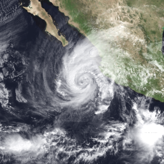
Hurricane Ismael was a weak, but deadly Pacific hurricane that killed over one hundred people in northern Mexico in September of the 1995 Pacific hurricane season. It developed from a persistent area of deep convection on September 12, and steadily strengthened as it moved to the north-northwest. Ismael attained hurricane status on September 14 while located 210 miles (340 km) off the coast of Mexico. It continued to the north, and after passing a short distance east of Baja California Sur it made landfall on Topolobampo in the state of Sinaloa with winds of 80 mph (130 km/h). Ismael rapidly weakened over land, and dissipated on September 16 over northwestern Mexico. The remnants entered the United States and extended eastward into the Mid-Atlantic States.

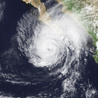
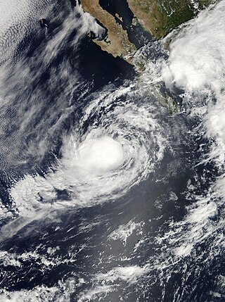
Hurricane Marty was a Category 2 Pacific hurricane that caused extensive flooding and damage in northwestern Mexico just weeks after Hurricane Ignacio took a similar course. Marty was the thirteenth named storm, fourth hurricane, and the deadliest tropical cyclone of the 2003 Pacific hurricane season. Forming on September 18, it became the 13th tropical storm and fourth hurricane of the year. The storm moved generally northwestward and steadily intensified despite only a marginally favorable environment for development, and became a Category 2 hurricane before making two landfalls on the Baja California peninsula and mainland Mexico.
Hurricane John was a Category 4 hurricane that caused heavy flooding and extensive damage across most of the Pacific coast of Mexico in late August through early September 2006. John was the eleventh named storm, seventh hurricane, and fifth major hurricane of the 2006 Pacific hurricane season. Hurricane John developed on August 28 from a tropical wave to the south of Mexico. Favorable conditions allowed the storm to intensify quickly, and it attained peak winds of 130 mph (210 km/h) on August 30. Eyewall replacement cycles and land interaction with western Mexico weakened the hurricane, and John made landfall on southeastern Baja California Sur with winds of 110 mph (180 km/h) on September 1. It slowly weakened as it moved northwestward through the Baja California peninsula, and dissipated on September 4. Moisture from the remnants of the storm entered the southwest United States.

Hurricane Paul was a Category 2 Pacific hurricane that struck Mexico as a tropical depression in October 2006. The seventeenth named storm and tenth hurricane of the annual hurricane season, Paul developed from an area of disturbed weather on October 21. The cyclone slowly intensified as it moved into an area of warm waters and progressively decreasing wind shear. Paul attained hurricane status on October 23, and later that day the storm reached its peak intensity with maximum sustained winds of 105 mph (169 km/h), a strong Category 2 hurricane on the Saffir-Simpson scale. A strong trough turned the hurricane to the north and northeast into an area of strong vertical shear, and Paul weakened to a tropical storm on October 24. It accelerated northeastward, and after passing a short distance south of Baja California Sur the low level circulation became decoupled from the rest of the convection. Paul weakened to a tropical depression on October 25 a short distance off the coast of Mexico, and after briefly turning away from the coast it made landfall on northwestern Sinaloa on October 26. The depression dissipated shortly thereafter.

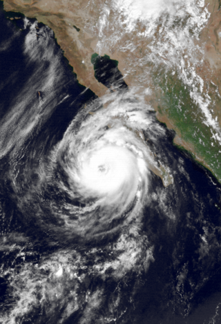
Hurricane Ignacio was the latest-forming first hurricane of a Pacific hurricane season since reliable satellite observation began in 1966. The ninth tropical storm of the 2003 Pacific hurricane season, Ignacio developed out of a tropical wave on August 22 a short distance off the coast of Mexico. It was initially predicted to track out to sea and remain a weak tropical storm, though it unexpectedly organized rapidly to attain peak winds of 105 mph (169 km/h) on August 24 while located a short distance southeast of southern Baja California Sur. Land interaction weakened Ignacio to an 80 mph (130 km/h) hurricane by the time it made landfall near La Paz, and it dissipated on August 27 in the central Baja California peninsula.
Hurricane Lester was the first Pacific tropical cyclone to enter the United States as a tropical storm since 1967. The fourteenth named storm and eighth hurricane of the 1992 Pacific hurricane season, Lester formed on August 20 from a tropical wave southwest of Mexico. The tropical storm moved generally northwestward while steadily intensifying. After turning to the north, approaching the Mexican coast, Lester attained hurricane status. The hurricane reached peak winds of 85 mph (137 km/h) before making landfall on west-central Baja California. The system weakened while moving across the peninsula and then over northwestern Mexico. Not long after entering Arizona, Lester weakened to a tropical depression, and degenerated into an extratropical low on August 24, 1992, over New Mexico. The storm's remnants later merged with the remnants of Hurricane Andrew and another frontal system on August 29.

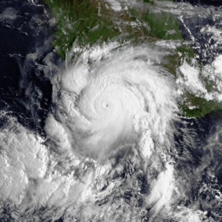
Hurricane Madeline was a costly tropical cyclone whose remnants caused hundreds of millions of dollars in damage in Texas in October 1998. The final tropical cyclone of the 1998 Pacific hurricane season, Madeline originated from a tropical wave that emerged off the coast of Africa on September 25, 1998. The wave traversed the Atlantic Ocean and crossed over Central America on October 5 or 6. Gradually, the system intensified and was classified as a tropical depression on October 16, a tropical storm later that day, and a hurricane on October 17. The storm reached peak winds of 85 mph (137 km/h) about 95 miles (153 km) southwest of San Blas, Nayarit, and after 18 hours it subsequently began to weaken. Although Madeline never made landfall, numerous rainbands affected the Mexican coast causing no known damage or fatalities. The remnant moisture moved north and contributed to flooding in central Texas, which killed 31 people and caused $750 million in damage.
Hurricane Fausto was a Pacific hurricane that caused light damage to Baja California Sur in September 1996. On September 10, a tropical depression developed a short distance south-southeast of the Mexican Riviera. Slowly intensifying, Fuasto paralleled the coastline. It became a hurricane on September 12, and after briefly reaching major hurricane intensity, increasing wind shear resulted in a weakening trend. It traversed Baja California Sur on September 13 as minimal hurricane, and struck Sinaloa the next day. Inland, it degenerated into a remnant circulation by September 15. Fausto's remnants continued moving eastward across the Gulf of Mexico and later emerged into the Atlantic, before developing into a large nor'easter on September 17. Afterward, the system moved northeastward, before it was last noted on September 18.
Tropical Storm Julio was a tropical storm that made landfall on the southern tip of Baja California Sur in August 2008. The eleventh named storm of the 2008 Pacific hurricane season, it developed from a tropical wave on August 23 off the coast of Mexico. It moved parallel to the coast, reaching peak winds of 50 mph (85 km/h) before moving ashore and weakening. On August 26 it dissipated in the Gulf of California. Julio was the third tropical cyclone to make landfall in the Eastern Pacific tropical cyclone basin during the season, after Tropical Storm Alma, which struck Nicaragua in May, and Tropical Depression Five-E, which moved ashore along southwestern Mexico in July. The storm brought locally heavy rainfall to southern Baja California, killing one person and leaving several towns isolated. Moisture from Julio reached Arizona, producing thunderstorms, including one which damaged ten small planes in Chandler.
Hurricane Rosa was the only Pacific hurricane to make landfall during the above-average 1994 Pacific hurricane season. It killed at least 4 people in Mexico. Moisture from the hurricane was a factor in widespread flooding in the U.S. state of Texas that killed 22 people and caused hundreds of millions of dollars in damage in October 1994. The pre-Rosa tropical depression formed on October 8 before degenerating the next day. It reformed on October 10 and steadily strengthened as it approached Mexico. Ultimately peaking as a Category 2 hurricane on the Saffir-Simpson Hurricane Scale right before landfall, Rosa was the final hurricane, nineteenth tropical storm, and second-last tropical cyclone of the 1994 Pacific hurricane season.
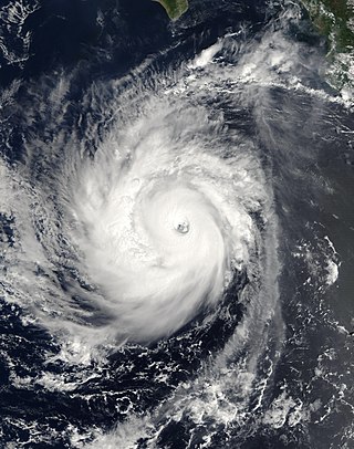
Hurricane Norbert is tied with Hurricane Jimena as the strongest tropical cyclone to strike the west coast of Baja California Sur in recorded history. The fifteenth named storm, seventh hurricane, and second major hurricane of the 2008 hurricane season, Norbert originated as a tropical depression from a tropical wave south of Acapulco on October 3. Strong wind shear initially prevented much development, but the cyclone encountered a more favorable environment as it moved westward. On October 5, the National Hurricane Center (NHC) upgraded the depression to Tropical Storm Norbert, and the system intensified further to attain hurricane intensity by October 6. After undergoing a period of rapid deepening, Norbert reached its peak intensity as a Category 4 on the Saffir–Simpson hurricane wind scale, with maximum sustained winds of 135 mph (217 km/h) and a minimum barometric pressure of 945 mbar. As the cyclone rounded the western periphery of a subtropical ridge over Mexico, it began an eyewall replacement cycle which led to steady weakening. Completing this cycle and briefly reintensifying into a major hurricane, a Category 3 or higher on the Saffir–Simpson hurricane wind scale, Norbert moved ashore Baja California Sur as a Category 2 hurricane late on October 11. After a second landfall at a weaker intensity the following day, the system quickly weakened over land and dissipated that afternoon.
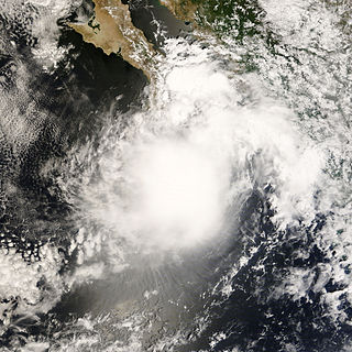
Tropical Storm Lowell was a moderate tropical storm that developed during the 2008 Pacific hurricane season. The fourteenth tropical cyclone and thirteen named storm of the season, Lowell formed out of a western side of a trough on September 6. It quickly intensified into Tropical Storm Lowell, peaking as a moderate tropical storm. It pass directly over Socorro Island and began a weakening trend. It weakened into depression before landfall in Baja California Sur and dissipated before striking Sonora. It later joined with a frontal boundary and Hurricane Ike which caused severe damage as far inland as Chicago. In all, the storm had caused 6 deaths and $15.5 million damage.

Hurricane Paine was the sixteenth tropical storm and eighth hurricane of the fairly active 1986 Pacific hurricane season; moisture from the system contributed to one of the most significant flooding events in Oklahoma history. Paine formed on September 28 off the southeast coast of Mexico. It moved around a ridge, later turning to the north and brushing the Baja California Peninsula. By that time, Paine had attained peak winds of 100 mph (160 km/h), but it weakened slightly before hitting the Mexican state of Sonora. The remnant moisture combined with a cold front to produce heavy rainfall in the South Central United States.

Hurricane Bud was a tropical cyclone that brought winds and severe flooding to Mexico throughout its existence as a tropical cyclone in June 2018. It was the second named storm, hurricane, and major hurricane of the 2018 Pacific hurricane season. Bud originated from a tropical wave that departed from Western Africa on May 29. It traveled across the Atlantic Ocean before entering the Northeast Pacific Ocean late on June 6. The system moved towards the northwest and steadily organized, becoming a tropical depression on June 9 and Tropical Storm Bud early the next day. Favorable upper-level winds, ample moisture aloft, and warm sea surface temperatures allowed the storm to rapidly intensify to a hurricane late on June 10, and further to a major hurricane on the following day. Bud ultimately peaked the next morning with maximum sustained winds of 140 mph (230 km/h) and a minimum central pressure of 943 mbar. Its track curved more northward while the storm rapidly succumbed to the effects of upwelling. Bud made landfall on Baja California Sur as a minimal tropical storm early on June 15. On the next day, land interaction and increasing wind shear caused Bud to degenerate into a post-tropical cyclone. It opened up into a trough of low-pressure on June 16. The remnants of Bud moved towards the Southwestern United States, bringing tropical moisture and gusty winds to the region.

Tropical Depression Nineteen-E was a weak yet costly tropical cyclone that caused significant flooding throughout Northwestern Mexico and several states within the United States in September 2018. The storm was also the first known tropical cyclone to form over the Gulf of California. Nineteen-E originated from a tropical wave that left the west coast of Africa on August 29 to 30. It continued westward, crossed over Central America, and entered the northeastern Pacific Ocean by September 7. It then meandered to the southwest of Mexico for the next several days as it interacted with a mid-to-upper level trough. The National Hurricane Center (NHC) continued to track the disturbance for the next several days as it traveled northward. A surface trough developed over the Baja California peninsula on September 18. Despite disorganization and having close proximity to land, the disturbance developed into a tropical depression in the Gulf of California on September 19, after having developed a circulation center and more concentrated convection. The system peaked with maximum sustained winds of 35 mph (55 km/h) and a minimum central pressure of 1002 mbar.

Hurricane Norma was one of four tropical cyclones to strike the Pacific Coast of Mexico in October 2023. The seventeenth tropical depression, fourteenth named storm, ninth hurricane and seventh major hurricane of the 2023 Pacific hurricane season, Norma developed from an area of low pressure that formed off the coast of southern Mexico on October 15, 2023. The disturbance gradually organized as it progressed westward parallel to the coast, and developed into Tropical Storm Norma on October 17. Turning northward, Norma rapidly intensified to a Category 4 hurricane as it continued to parallel the west coast of Mexico. Less favorable environmental conditions caused Norma to gradually weaken as it approached the Baja California peninsula. The cyclone made landfall on the Mexican state of Baja California Sur as a Category 1 hurricane. Norma continued to weaken as it crossed the state. The storm emerged over the Gulf of California on October 22, and made landfall as a tropical depression the following day on the state of Sinaloa. Norma quickly dissipated as it moved inland over Mexico.


