
Oxfordshire is a landlocked county in the far west of the government statistical region of South East England. The ceremonial county borders Warwickshire to the north-west, Northamptonshire to the north-east, Buckinghamshire to the east, Berkshire to the south, Wiltshire to the south-west and Gloucestershire to the west.

Banbury is a historic market town on the River Cherwell in Oxfordshire, South East England. It had a population of 46,853 at the 2011 census.

California is a hamlet to the south side of Aylesbury town centre in Buckinghamshire in England, although today it has been completely swallowed up by the urban growth of Aylesbury.
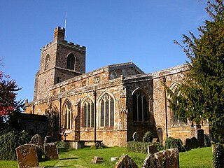
Cropredy is a village and civil parish on the River Cherwell, 4 miles (6.4 km) north of Banbury in Oxfordshire.

Thorpe Mandeville is a village and civil parish in West Northamptonshire, England about 6 miles (10 km) northeast of Banbury in neighbouring Oxfordshire. The hamlet of Lower Thorpe is just north of the village.

Tackley is a village and civil parish beside the River Cherwell in Oxfordshire, England. It is about 6 miles (10 km) west of Bicester and 4+1⁄2 miles (7 km) north of Kidlington. The village consists of two neighbourhoods: Tackley itself, and Nethercott. The 2011 Census recorded the parish's population as 998.

Grimsbury is a largely residential area forming the eastern part of Banbury, Oxfordshire, England. It is east of the River Cherwell, the Oxford Canal and the Cherwell Valley Line railway.

Neithrop is an inner housing estate and part of the greater 'Neithrop ward' of Banbury, Oxfordshire, England. It is one of the oldest areas in Banbury, having first been first recorded as a hamlet in the 13th century. Neithrop, Woodgreen and Bretch Hill are three interconnecting housing estates.

Easington, Poets Corner and the Timms estate are three interconnecting estates in the town of Banbury, Oxfordshire.

Calthorpe is an historic manor in Oxfordshire, now a ward in the town of Banbury, Oxfordshire. It contains the modern housing estates of Cherwell Heights and Calthorpe.

Arlescote is a village in Warwickshire, England.
Thrupp is a hamlet just north of Kidlington in Oxfordshire. It is beside the Oxford Canal and close to the River Cherwell.
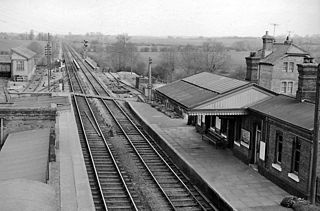
Bletchington railway station is a disused station in Oxfordshire at Enslow, England, a hamlet 1.25 miles (2 km) west of the village of Bletchingdon. The station had a number of names during its period of operation: 'Woodstock', 'Woodstock Road', 'Kirtlington' and finally 'Bletchington'.
Clattercote or Clattercot is a hamlet in Claydon with Clattercot civil parish, just over 5.5 miles (8.9 km) north of Banbury in Oxfordshire, England.

Prescote is a hamlet and civil parish about 4 miles (6.4 km) north of Banbury in Oxfordshire. Its boundaries are the River Cherwell in the southeast, a tributary of the Cherwell called Highfurlong Brook in the west, and Oxfordshire's boundary with Northamptonshire in the northeast.
Foxcotte is a small hamlet in the civil parish of Charlton in the Test Valley district of Hampshire, England. Its nearest town is Andover, which only lies approximately 1.7 miles (2.7 km) south-east from the hamlet.
The Ruscote, Hardwick and Hanwell Fields estates are three interconnecting Banbury estates that were built between the 1930s and 2000s in Oxfordshire, England.
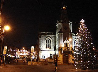
Banbury is a circa 1,500-year-old market town and civil parish on the River Cherwell in the Cherwell District of Oxfordshire, England. It is 64 miles (103 km) northwest of London, 38 miles (61 km) southeast of Birmingham, 27 miles (43 km) south of Coventry and 21 miles (34 km) north northwest of the county town of Oxford.

Banbury cheese was an English cheese produced in Banbury, Oxfordshire. Once one of the town's most prestigious exports, and nationally famous, the production of the cheese went into decline by the 18th century, and was eventually forgotten. The cheese is best known today through an insult in Shakespeare's Merry Wives of Windsor (1597).
Nethercote is a hamlet on the edge of north Oxfordshire, a semi-rural area bordering with West Northamptonshire. The hamlet sits South East of J11 of M40, lying South of the A422 and East of the M40. Predominantly agricultural land used for grazing, a single-track road runs right through the hamlet, known as Banbury Lane, which has around a dozen residential properties along the lane. Banbury Lane is still often referred to as Blacklocks Hill and this refers to the history of the area and a time when this area saw a main route into Banbury, before the M40 and A422. In 1870-72 it had a population of 97.
