
New Dorp is a neighborhood on the East Shore of Staten Island, New York City, United States. New Dorp is bounded by Mill Road on the southeast, Tysens Lane on the southwest, Amboy and Richmond Roads on the northwest, and Bancroft Avenue on the northeast. It is adjacent to Oakwood to the southwest, Todt Hill to the northwest, Dongan Hills and Grant City, and Midland Beach and Miller Field to the southeast. New Dorp Beach, bordering to the east, is often listed on maps as a separate neighborhood from Mill Road to the shore of Lower New York Bay, but is generally considered to be a part of New Dorp.

The South Shore is a geographical term applied to the area in the New York City borough of Staten Island, south and east of the island's ridge of hills along the waterfront and adjacent areas from the Narrows to the mouth of the Arthur Kill. Many observers prefer to restrict its scope to the neighborhoods located between the shoreline of Raritan Bay on one side and Richmond Creek and Fresh Kills on the other, thus encompassing the neighborhoods of Great Kills to Tottenville only. Those who use this narrower definition of the "South Shore" prefer the term "East Shore" for the communities that lie along Lower New York Bay, and inland for approximately 2 to 2½ miles, from Bay Terrace and Richmondtown to as far north as Grasmere and Concord. The South Shore is represented in the New York City Council by Joe Borelli.

Staten Island Mall is a shopping mall in New Springville, Staten Island, New York City, opened in 1973. It is the only indoor shopping mall in the borough. It is the largest retail center on the island and is the site of the island's third-largest public transit hub after the St. George Terminal and Eltingville Transit Center, with numerous bus routes that connect to the periphery of the mall area. It is the second-biggest shopping center in NYC. The anchor stores are Macy's, Dave & Buster's, Barnes & Noble, Ulta Beauty, AMC Theatres, Primark, Lidl, The Container Store, and JCPenney. There is a vacant anchor store that was once Sears.

Midland Beach is a neighborhood of Staten Island in New York City. It lies along the east-central coast of the island, in the area known locally as the "Mid-Island, Staten Island" or the "East Shore".

The term East Shore is frequently applied to a series of neighborhoods along the Lower New York Bay and the Raritan Bay and within New York City's borough of Staten Island.

Oakwood is a neighborhood located in east central Staten Island, New York City, near the South Shore. It is bordered by Tysens Lane (north); the Atlantic Ocean (east); Great Kills Park (south); Kensico Street, and Clarke Avenue (west).

Dongan Hills is a neighborhood located within the New York City borough of Staten Island. It is on the Island's East Shore. Dongan Hills is bounded by Laconia Avenue on the southeast, Jefferson Avenue on the southwest, Richmond Road on the northwest, and Old Town Road to the north. It is adjacent to New Dorp and Grant City to the southwest, Todt Hill to the northwest, Old Town/Concord to the northeast, and South Beach and Midland Beach to the southeast.
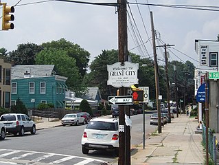
Grant City is the name of a neighborhood located on the East Shore of Staten Island, New York City.

Bay Terrace is the name of a neighborhood, centered around the street of the same name, on the East Shore of Staten Island, one of the five boroughs of New York City. It is represented in the New York City Council by Joe Borelli.

Grasmere is the name of a neighborhood located on the East Shore of Staten Island, one of the five boroughs of New York City.
New Dorp Beach is along the shore of the neighborhood of New Dorp, on Staten Island, one of the five boroughs of New York City. It is between Midland Beach and Oakwood Beach.
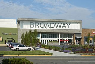
Broadway Commons, better known by its former name Broadway Mall, is a large shopping mall located in Hicksville, New York, United States. Originally an open-air shopping center called the Mid-Island Shopping Plaza, Broadway Mall is currently a regional enclosed shopping center comprising 98 stores, as well as a food court and movie theater. The mall's anchor stores are IKEA, Target, Blink Fitness, Round 1 Entertainment, and H&M There is one vacant anchor store that was once Macy's.
Hylan Boulevard is a major northeast-southwest boulevard in the New York City borough of Staten Island, and the longest street in the city. It is approximately 14 miles (23 km) long, and runs from the North Shore neighborhood of Rosebank, then along the entire East Shore, to the South Shore neighborhood of Tottenville. It was renamed in 1923 for New York City mayor John F. Hylan, before which it was known as Southfield Boulevard and the northern segment as Pennsylvania Avenue.
Long Pond Park is a park preserve on the South Shore of Staten Island, New York City. It is approximately 115 acres (0.47 km2) in size and consists mainly of woodlands and wetlands that surround Long Pond, for which the park is named. Long Pond Park is roughly bounded by Hylan Boulevard on the south, Page Avenue on the west, Amboy Road on the north, and Richard Avenue on the east. It is an important stopping point for migrating birds in the Atlantic Flyway.

The Olmsted–Beil House was a large farm and modest Dutch farmhouse at 4515 Hylan Boulevard in the South Shore of Staten Island, New York City. The house was purchased by Frederick Law Olmsted's father and given to Olmsted in 1848 to grow crops, plant trees and clear for pasture for livestock. It is on one of the higher hills overlooking Raritan Bay, and Sandy Hook in New Jersey.

The Marketplace Mall is a shopping center managed by Wilmorite and located in the heart of the Rochester, New York metropolitan area on Hylan Drive, in the suburb of Henrietta.

Old Town is a neighborhood in the New York City borough of Staten Island, located on its East Shore. Old Town was established in August 1661 as part of New Netherland, and was the first permanent European settlement on Staten Island. Originally described as "Oude Dorpe", much of its original territory makes up what is present-day South Beach, with parts of Midland Beach and Dongan Hills. The area was settled by a group of Dutch, Walloon and French Protestants (Huguenots) led by Walloon Pierre Billiou.

Father Capodanno Boulevard, formerly Seaside Boulevard, is the primary north-south artery that runs through the Arrochar, South Beach, Ocean Breeze, Midland Beach, and New Dorp Beach neighborhoods of the New York City borough of Staten Island. The boulevard runs parallel to the South Beach Boardwalk and its public park.

Buono Beach is a small shorefront public park in the New York City borough of Staten Island, in the neighborhood of Rosebank, at the foot of Hylan Boulevard. Buono Beach borders New York Harbor and is adjacent to the park containing the Alice Austen House. The park contains a local veterans' memorial fountain.
Tompkins Avenue is a mostly residential yet primary east-west artery that runs through the Fort Wadsworth, Rosebank, Shore Acres, Clifton, and Stapleton neighborhoods of New York City, in the borough of Staten Island, New York.
