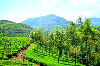
Munnar is a town and hill station located in the Idukki district of the southwestern Indian state of Kerala. Munnar is situated at around 1,600 metres (5,200 ft) above mean sea level, in the Western Ghats mountain range. Munnar is also called the "Kashmir of South India" and is a popular honeymoon destination.
Painavu is the administrative headquarters of Idukki district of Kerala, in southwestern India.
Kothamangalam is a municipality at the foot of the Western Ghats in the Ernakulam district of Kerala, India. It is located 31 km (19.3 mi) east of the district collectorate in Thrikkakara and about 177 km (110.0 mi) north of the state capital Thiruvananthapuram. As per the 2011 Indian census, Kothamangalam has a population of 38,837 people, and a population density of 969/km2 (2,510/sq mi).

Pathanamthitta, is a municipality situated in the Southern Kerala, India, spread over an area of 23.50 km2. It is the administrative capital of Pathanamthitta district. The town has a population of 37,538. The Hindu pilgrim centre Sabarimala is situated in the Pathanamthitta district; as the main transport hub to Sabarimala, the town is known as the 'Pilgrim Capital of Kerala'. Pathanamthitta District, the thirteenth revenue district of the State of Kerala, was formed with effect from 1 November 1982, with headquarters at Pathanamthitta. Forest covers more than half of the total area of the District. Pathanamthitta District ranks the 7th in area in the State. The district has its borders with Allepey, Kottayam, Kollam and Idukki districts of Kerala and Tamil Nadu. Nearest town is Thiruvalla, located at a distance of 30 km. Thiruvalla railway station is 30 km via Thiruvalla-Kumbazha highway. Buses ply every 5 Minutes from Thiruvalla To Pathanamthitta & vice versa.
Pathirippala is a town in Palakkad district, Kerala, India, between Ottappalam and Palakkad on the Palakkad–Ponnani state highway SH 23.

Yendayar is a village in Kottayam district, Kerala, India that is totally surrounded by hills. The local river is the Manimala.

Eravathur is a small village situated towards the south end of Thrissur district of Kerala state in India. This village is situated nearly 40 km (25 mi) away from Ernakulam city and nearly 45 km (28 mi) from Thrissur city.

Bison valley is a village in Udumbanchola Taluk in the Idukki district of the southwestern Indian state of Kerala. Bison valley is situated at around 914 metres (3000 ft) above mean sea level, in the Western Ghats range of mountains.
Kunchithanny is a village situated in the Idukki district in the Indian state of Kerala. The village is located on the banks of the river Muthirappuzha.
Rajakkad is a town in the Idukki district in the Indian state of Kerala situated in the Western Ghats.

Thirumeni is a village in Kannur district in the Kerala state of India. It is known for its hill station Chathamangalam Hills. The village has several recently migrated families from various parts of the erstwhile political entity (state) of Travancore who settled here in the famed "Malabar migration period" in the nineteenth century. Most of the inhabitants of the village reside in the valley of three major hills by name Chathamangalam Theruvamala alias Alumbumala, Kottathalachimala and Thevarkunnumala. Thirumeni is a small junction with a few government institutions, religious institutions and small shops in int. and is subdivided into smaller villages like Kokkadave, Prapoyil, Chathamangalam (Kannur), Thabore, Muthuvom, Korali, Chattivayal, Thannichal, Paruthikallu etc.

Bandadka is a small town in Kasaragod district in the state of Kerala, India. It is also called Kottakal because of Bandadka Fort. It comes under Kuttikole Grama Panchayat. It is located 38 km (24 mi) towards east from the District headquarters Kasaragod, 568 km (353 mi) away from the State capital Thiruvananthapuram, 5 km (3.1 mi) west of Karnataka border and 20 km (12 mi) away from Sullia. Bandadka's pin code is 671541 and its postal head office is Chengala.
Anikkad is a village in Ernakulam district in the state of Kerala, India. It is located near the Muvattupuzha town in Avoly Panchayat.
Pampupara is a village in the Idukki district of Kerala, India. It is located between Sulthankada and Kadasikadavu. This settlement is famous for its cardamom plantations, pepper grows and paddy fields.

Angamoozhy is a village in Pathanamthitta district in the Indian state of Kerala. Angamoozhy is located near the Kakkad power station and the Sabarimala temple. Geographically Angamoozhy is High-range area.
Anandapally is a place in Kerala The nearest railway station Chengannur, about 25 km from Adoor. The nearest airport Thiruvananthapuram International Airport, about 92 km from Adoor. It lies on a road from the northern part of Kerala to the Hindu pilgrimage centre - Sabarimala.

Kanjikode or Kanchikode is an industrial town located 13 km (8.1 mi) east of Palakkad. Kanjikode is the second largest industrial hub in Kerala after Kochi. The town is part of Pudussery Panchayat. It is one of the growing suburbs of Palakkad city. First and the only Indian Institute of Technology in Kerala, Indian Institute of Technology,Palakkad was established in Kanjikode.

The KDHP Tea Museum is an industry and history museum situated in Munnar, a town in the Idukki district of Kerala in South India. Tata Tea Museum is its official name, but it's also known as Nullathanni Estate where it is located, or Kannan Devan Hills Plantation (KDHP) Tea Museum.

Padera, also spelled Pandera, is a village in Harchandpur block of Raebareli district, Uttar Pradesh, India. As of 2011, its population is 3,034, in 564 households. It has one primary school and no healthcare facilities.
Parathanam is a town at the base of Western Ghats mountain ranges in the Kottayam district, Kerala. It is 2,000 feet above sea level and is situated on the eastern border of Kottayam District, 60 km from Kottayam, 12 km away from Poonjar and around 8 km away from Mundakayam on the NH 220.


