The Cayman Islands is an autonomous British Overseas Territory in the western Caribbean Sea. The 264-square-kilometre (102-square-mile) territory comprises the three islands of Grand Cayman, Cayman Brac and Little Cayman, which are located to the south of Cuba and northeast of Honduras, between Jamaica and the Yucatán Peninsula. As of spring 2018, the total population of the Cayman Islands is estimated to be 64,420 making it the second-most populated British overseas territory after Bermuda. The capital city is George Town, situated on Grand Cayman, by far the most populous of the three islands.

The Canary Islands is a Spanish archipelago and the southernmost autonomous community of Spain located in the Atlantic Ocean, 100 kilometres west of Morocco at the closest point. The Canary Islands, which are also known informally as the Canaries, are among the outermost regions (OMR) of the European Union proper. It is also one of the eight regions with special consideration of historical nationality recognized as such by the Spanish Government. The Canary Islands belong to the African Plate like the Spanish cities of Ceuta and Melilla, the two on the African mainland.

Malta, officially known as the Republic of Malta, is a Southern European island country consisting of an archipelago in the Mediterranean Sea. It lies 80 km (50 mi) south of Italy, 284 km (176 mi) east of Tunisia, and 333 km (207 mi) north of Libya. With a population of about 475,000 over an area of 316 km2 (122 sq mi), Malta is the world's tenth smallest and fifth most densely populated country. Its capital is Valletta, which is the smallest national capital in the European Union by area at 0.8 km.2 The official languages are Maltese and English, with Maltese officially recognised as the national language and the only Semitic language in the European Union.

Mauritius, officially the Republic of Mauritius, is an island nation in the Indian Ocean. The main Island of Mauritius is located about 2,000 kilometres (1,200 mi) off the southeast coast of the African continent. The Republic of Mauritius also includes the islands of Rodrigues, Agalega and St. Brandon. The capital and largest city Port Louis is located on the main island of Mauritius.
The Pitcairn Islands, officially Pitcairn, Henderson, Ducie and Oeno Islands, are a group of four volcanic islands in the southern Pacific Ocean that form the sole British Overseas Territory in the South Pacific Ocean. The four islands—Pitcairn proper, Henderson, Ducie and Oeno—are scattered across several hundred miles of ocean and have a combined land area of about 18 square miles (47 km2). Henderson Island accounts for 86% of the land area, but only Pitcairn Island is inhabited. The nearest places are Mangareva to the west and Easter Island to the east.

Rhode Island, officially the State of Rhode Island and Providence Plantations, is a state in the New England region of the United States. It is the smallest state in area, the seventh least populous, the second most densely populated, and it has the longest official name of any state. Rhode Island is bordered by Connecticut to the west, Massachusetts to the north and east, and the Atlantic Ocean to the south via Rhode Island Sound and Block Island Sound. It also shares a small maritime border with New York. Providence is the state capital and most populous city in Rhode Island.
Seychelles, officially the Republic of Seychelles, is an archipelago country in the Indian Ocean. The capital of the 115-island country, Victoria, lies 1,500 kilometres (932 mi) east of mainland East Africa. Other nearby island countries and territories include Comoros, Mayotte, Madagascar, Réunion and Mauritius to the south; as well as the Maldives and British Indian Ocean Territory to the east. With a population of roughly 94,228, it has the smallest population of any sovereign African country.

The Turks and Caicos Islands are a British Overseas Territory consisting of the larger Caicos Islands and smaller Turks Islands, two groups of tropical islands in the Lucayan Archipelago of the Atlantic Ocean and northern West Indies. They are known primarily for tourism and as an offshore financial centre. The resident population is 31,458 as of 2012 of whom 23,769 live on Providenciales in the Caicos Islands. It is the third largest of the British overseas territories by population.

The United States Virgin Islands, officially the Virgin Islands of the United States, is a group of islands in the Caribbean and an unincorporated and organized territory of the United States. The islands are geographically part of the Virgin Islands archipelago and are located in the Leeward Islands of the Lesser Antilles.

Easter Island is a Chilean island in the southeastern Pacific Ocean, at the southeasternmost point of the Polynesian Triangle in Oceania. Easter Island is most famous for its nearly 1,000 extant monumental statues, called moai, created by the early Rapa Nui people. In 1995, UNESCO named Easter Island a World Heritage Site, with much of the island protected within Rapa Nui National Park.

Great Britain is an island in the North Atlantic Ocean off the northwest coast of continental Europe. With an area of 209,331 km2 (80,823 sq mi), it is the largest of the British Isles, the largest European island, and the ninth-largest island in the world. In 2011, Great Britain had a population of about 61 million people, making it the world's third-most populous island after Java in Indonesia and Honshu in Japan. The island of Ireland is situated to the west of Great Britain, and together these islands, along with over 1,000 smaller surrounding islands, form the British Isles archipelago.

The Faroe Islands, or the Faeroe Islands—a North Atlantic archipelago located 200 miles (320 km) north-northwest of the United Kingdom and about halfway between Norway and Iceland—are an autonomous country of the Kingdom of Denmark. Total area is about 1,400 square kilometres (540 sq mi) with a population of 50,322 in October 2017.
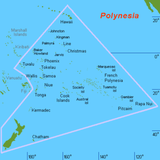
Polynesia is a subregion of Oceania, made up of more than 1,000 islands scattered over the central and southern Pacific Ocean. The indigenous people who inhabit the islands of Polynesia are termed Polynesians, and share many similar traits including language family, culture, and beliefs. Historically, they had a strong tradition of sailing and using stars to navigate at night. The largest country in Polynesia is New Zealand.
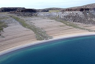
Kanuyak Island is a member of the Barry Islands within the Canadian Arctic Archipelago in the Kitikmeot Region, Nunavut. It is located in Bathurst Inlet. Other islands in the vicinity include Iglorua Island, Ekalulia Island, Algak Island, Shoe Island, and Rideout Island.
Ekalulia Island is an uninhabited island within the Canadian Arctic Archipelago in the Kitikmeot Region, Nunavut. It is located in Bathurst Inlet. Other islands in the vicinity include Algak Island, Kanuyak Island, Iglorua Island, Shoe Island, Walrus Island, Marcet Island, Rideout Island, and Fishers Island.
Shoe Island is an uninhabited island within the Canadian Arctic Archipelago in the Kitikmeot Region, Nunavut. It is located in Bathurst Inlet. Other islands in the vicinity include Algak Island, Kanuyak Island, Iglorua Island, Ekalulia Island, and Rideout Island.
Walrus Island is an uninhabited island within the Canadian Arctic Archipelago in the Kitikmeot Region, Nunavut. It is located in Bathurst Inlet. Other islands in the vicinity include Ekalulia Island, Lewes Island, Patsy Klengenberg Island, Galena Island, Iglorua Island, Marcet Island, and Fishers Island.
Fishers Island is an uninhabited island within the Canadian Arctic Archipelago in the Kitikmeot Region, Nunavut. It is located in Bathurst Inlet. Other islands in the vicinity include Ekalulia Island, Lewes Island, Patsy Klengenberg Island, Iglorua Island, and Walrus Island.
Marcet Island is an uninhabited island within the Canadian Arctic Archipelago in the Kitikmeot Region, Nunavut. It is located in Bathurst Inlet. Other islands in the vicinity include Galena Island, Ekalulia Island, Lewes Island, Patsy Klengenberg Island, Iglorua Island, and Walrus Island.