The Battle of Lewes was one of two main battles of the conflict known as the Second Barons' War. It took place at Lewes in Sussex, on 14 May 1264. It marked the high point of the career of Simon de Montfort, 6th Earl of Leicester, and made him the "uncrowned King of England". Henry III left the safety of Lewes Castle and St. Pancras Priory to engage the Barons in battle and was initially successful, his son Prince Edward routing part of the baronial army with a cavalry charge. However Edward pursued his quarry off the battlefield and left Henry's men exposed. Henry was forced to launch an infantry attack up Offham Hill where he was defeated by the barons' men, defending the hilltop. The royalists fled back to the castle and priory and the King was forced to sign the Mise of Lewes, ceding many of his powers to Montfort.

Lewes is the county town of East Sussex and by tradition of all of Sussex. Lewes remains the police and judicial centre for all of Sussex and is home to Sussex Police, East Sussex Fire & Rescue Service, Lewes Crown Court and HMP Lewes. It is a civil parish and is the centre of the Lewes local government district as well as the seat of East Sussex County Council at East Sussex County Hall. The population of Lewes is now around 17,000. The settlement is a traditional market town and centre of communications and, in 1264, it was the site of the Battle of Lewes. The town's landmarks include Lewes Castle, the remains of Lewes Priory, Bull House, Southover Grange and public gardens, and a 16th century timber-framed Wealden hall house known as Anne of Cleves House. Other notable features of the area include the Glyndebourne festival, the Lewes Bonfire and the Lewes Pound.

U.S. Route 9 is a north–south United States highway in the states of Delaware, New Jersey, and New York in the United States. It is one of only two U.S. Highways with a ferry connection ; the other is US 10. US 9 is signed east–west in Delaware and north–south on the rest of its route. The southern terminus of the route is in Laurel, Delaware, at an intersection with U.S. Route 13, while the highway's northern terminus is at a junction with Interstate 87 in Champlain, New York, where the roadway continues north as the unsigned NY 971B, which ends in a cul-de-sac just short of the Canada–US border. The highway is mentioned in the Bruce Springsteen songs "Born to Run" and "The Promise", "My Geraldine Lies Over the Delaware" by The Wonder Years (band) and "The Devil On Hwy 9" by Danzig (band). The highway, particularly the section around Freehold, New Jersey, is associated with Springsteen more generally.

Lewes is an incorporated city on the Delaware Bay in eastern Sussex County, Delaware. According to the 2010 census, the population is 2,747. Along with neighboring Rehoboth Beach, Lewes is one of the principal cities of Delaware's rapidly growing Cape Region. The city lies within the Salisbury, Maryland–Delaware Metropolitan Statistical Area. Lewes proudly claims to be "The First Town in The First State."
Lewes is the county town of East Sussex in the United Kingdom.
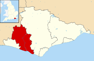
Lewes is a local government district in East Sussex in southern England covering an area of 113 sq mi (290 km2), with 9 miles (14.5 km) of coastline. It is named after its administrative centre, Lewes. Other towns in the district include Newhaven, Peacehaven, Seaford and Telscombe. Plumpton racecourse is within the district. There are 28 parishes in the district.

Lewes is a constituency in East Sussex represented in the House of Commons of the UK Parliament since 2015 by Maria Caulfield, a Conservative.

Barcombe is an East Sussex village about 4–5 miles (6.4 km) north of Lewes. It more broadly a civil parish in the Lewes District of East Sussex. Barcombe itself is the older of three settlements in the parish; Barcombe Cross is much more populous and the main hub with the amenities and services, where the villagers evacuated during medieval plague the Black Death; and the latter has a near outpost north of Barcombe Mills on the River Ouse. Hamlets are Spithurst in the north east and Town Littleworth in the north west.
David Hall was an American lawyer and politician from Lewes, in Sussex County, Delaware. He was an officer in the Continental Army during the American Revolution, and member of the Democratic-Republican Party, who served as Governor of Delaware.

Lot 60 is a township in Queens County, Prince Edward Island, Canada. It is part of St. John's Parish. In the 1767 land lottery, Lot 60 was awarded to Major John Wrightson and Captain Daniel Shaw of the 42nd Regiment of Foot.

Lewes Football Club is a football club based in Lewes, East Sussex, England. They are currently members of the Isthmian League Premier Division and play at the Dripping Pan.
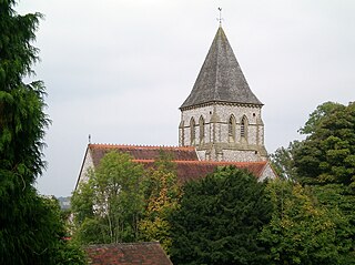
Hamsey is a civil parish in the Lewes District of East Sussex, England. It is located three miles (5 km) north of Lewes on the Prime Meridian. The original village, now abandoned apart from the church and a few cottages, lay on an island in the River Ouse; the parish consists of the villages of Hamsey with Offham and Cooksbridge being the main centres of population in the parish.

Clan MacLeod of The Lewes, commonly known as Clan MacLeod of Lewis, is a Highland Scottish clan, which at its height held extensive lands in the Western Isles and west coast of Scotland. From the 14th century up until the beginning of the 17th century there were two branches of Macleods: the MacLeods of Dunvegan and Harris ; and the Macleods of Lewis. In Gaelic the Macleods of Lewis were known as Sìol Thorcaill, and the MacLeods of Dunvegan and Harris were known as Sìol Thormoid.
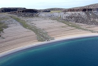
The uninhabited Stockport Islands are members of the Canadian Arctic Archipelago in the territory of Nunavut. They are located in Bathurst Inlet, east of Daniel Moore Bay, and south of Lewes Island.
Walrus Island is an uninhabited island within the Canadian Arctic Archipelago in the Kitikmeot Region, Nunavut. It is located in Bathurst Inlet. Other islands in the vicinity include Ekalulia Island, Lewes Island, Patsy Klengenberg Island, Galena Island, Iglorua Island, Marcet Island, and Fishers Island.
Marcet Island is an uninhabited island within the Canadian Arctic Archipelago in the Kitikmeot Region, Nunavut. It is located in Bathurst Inlet. Other islands in the vicinity include Galena Island, Ekalulia Island, Lewes Island, Patsy Klengenberg Island, Iglorua Island, and Walrus Island.
Galena Island is an uninhabited island within the Canadian Arctic Archipelago in the Kitikmeot Region, Nunavut. It is located in Bathurst Inlet. Other islands in the vicinity include Lewes Island, Marcet Island, and Walrus Island.
Patsy Klengenberg Island is an uninhabited island within the Canadian Arctic Archipelago in the Kitikmeot Region, Nunavut. It is located in Bathurst Inlet. Other islands in the vicinity include Lewes Island, Marcet Island, and Walrus Island.