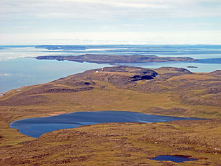
Takhoalok Island

Last updated
Takhoalok Island
Geography
Location Coronation Gulf
Coordinates 68°10′N112°08′W / 68.167°N 112.133°W / 68.167; -112.133 (Takhoalok Island) Coordinates: 68°10′N112°08′W / 68.167°N 112.133°W / 68.167; -112.133 (Takhoalok Island)
Archipelago Canadian Arctic Archipelago
Administration
Territory Nunavut
Region Kitikmeot
Demographics
PopulationUninhabited

Takhoalok Island is an island located within Coronation Gulf, south of Victoria Island, in the Kitikmeot Region, Nunavut, Canada. Its highest point is 48 m (157 ft) above sea level. [1]

Coronation Gulf bay

Coronation Gulf lies between Victoria Island and mainland Nunavut in Canada. To the northwest it connects with Dolphin and Union Strait and thence the Beaufort Sea and Arctic Ocean; to the northeast it connects with Dease Strait and thence Queen Maud Gulf.

Victoria Island (Canada) island in arctic Canada

Victoria Island is a large island in the Canadian Arctic Archipelago that straddles the boundary between Nunavut and the Northwest Territories of Canada. It is the eighth largest island in the world, and at 217,291 km2 (83,897 sq mi) in area, it is Canada's second largest island. It is nearly double the size of Newfoundland (111,390 km2 [43,008 sq mi]), and is slightly larger than the island of Great Britain (209,331 km2 [80,823 sq mi]) but smaller than Honshu (225,800 km2 [87,182 sq mi]). It contains the world's largest island within an island within an island. The western third of the island belongs to the Inuvik Region in the Northwest Territories; the remainder is part of Nunavut's Kitikmeot Region.

Nunavut Territory of Canada

Nunavut is the newest, largest, and most northerly territory of Canada. It was separated officially from the Northwest Territories on April 1, 1999, via the Nunavut Act and the Nunavut Land Claims Agreement Act, though the boundaries had been contemplatively drawn in 1993. The creation of Nunavut resulted in the first major change to Canada's political map since the incorporation of the province of Newfoundland in 1949.

Other islands in the vicinity include Anchor Island, Duke of York Archipelago, Hokagon Island, Doak Island, Kingak Island, Mangak Island, and Nanukton Island. [2]

Anchor Island (Nunavut) island in Canada

Anchor Island is an island located within Coronation Gulf, south of Victoria Island, in the Kitikmeot Region, Nunavut, Canada.

The Duke of York Archipelago is an uninhabited island group in the Kitikmeot Region, Nunavut, Canada. It is located in the Coronation Gulf.

Hokagon Island is an island located within Coronation Gulf, south of Victoria Island, in the Kitikmeot Region, Nunavut, Canada.
Related Research Articles

Antigua and Barbuda Country in the Caribbean

Antigua and Barbuda is a country in the West Indies in the Americas, lying between the Caribbean Sea and the Atlantic Ocean. It consists of two major islands, Antigua and Barbuda, and a number of smaller islands. The permanent population numbers about 81,800 and the capital and largest port and city is St. John's on Antigua. Lying near each other, Antigua and Barbuda are in the middle of the Leeward Islands, part of the Lesser Antilles, roughly at 17°N of the equator.

Turks and Caicos Islands British Overseas Territory in the Caribbean

The Turks and Caicos Islands are a British Overseas Territory consisting of the larger Caicos Islands and smaller Turks Islands, two groups of tropical islands in the Lucayan Archipelago of the Atlantic Ocean and northern West Indies. They are known primarily for tourism and as an offshore financial centre. The resident population is 31,458 as of 2012 of whom 23,769 live on Providenciales in the Caicos Islands. It is the third largest of the British overseas territories by population.

Skagit County, Washington county in the U.S. state of Washington

Skagit County is a county in the U.S. state of Washington. As of the 2010 census, the population was 116,901. The county seat and largest city is Mount Vernon. The county was formed in 1883 from Whatcom County and is named for the Skagit Indian tribe, which has been indigenous to the area prior to European-American settlement.

Lists of earthquakes A directory to Wikipedia lists of earthquakes

The following is a list of earthquake lists, and of top earthquakes by magnitude and fatalities.

Rhode Island School of Design Private art and design college in Providence, Rhode Island

Rhode Island School of Design is a fine arts and design college located in Providence, in the U.S. state of Rhode Island. It has consistently been ranked among the best educational institutions in the world for art and design.

Mount Odin mountain in Qikiqtaaluk, Nunavut, Canada

Mount Odin is a mountain in Qikiqtaaluk, Nunavut, Canada. It is located in Auyuittuq National Park along the Akshayuk Pass, 46 km (29 mi) north of Pangnirtung and south of Mount Asgard. Mount Odin is the highest mountain on Baffin Island.

Kingak Island is an island located within Coronation Gulf, south of Victoria Island, in the Kitikmeot Region, Nunavut, Canada. Its highest point is 40 m (130 ft) above sea level.

Doak Island is an island located within Coronation Gulf, south of Victoria Island, in the Kitikmeot Region, Nunavut, Canada. It is approximately 4 m (13 ft) above sea level.

Edinburgh Island

Edinburgh Island is an island located within Coronation Gulf, south of Victoria Island, in the Kitikmeot Region, Nunavut, Canada. It is approximately 103 m (338 ft) above sea level.

Upright Channel Park is a former unit of the Washington State Park System consisting of 20 acres (8.1 ha) of island, beach, and tidelands on Upright Channel in the northwest corner of Lopez Island. The park was not listed as a Washington State Parks property as of March 2014. San Juan County assumed management of the property per a Memorandum of Understanding in May 2014.

Ipanema, Minas Gerais is a municipality in the state of Minas Gerais in the Southeast region of Brazil.

Pontal do Paraná Municipality in Southern, Brazil

Pontal do Paraná is a municipality in the state of Paraná in the Southern Region of Brazil.

Serranópolis do Iguaçu is a municipality in the state of Paraná in the Southern Region of Brazil.

Pinhal de São Bento is a municipality in the state of Paraná in the Southern Region of Brazil.

Kegalle electoral district is one of the 22 multi-member electoral districts of Sri Lanka created by the 1978 Constitution of Sri Lanka. The district is conterminous with the administrative district of Kegalle in the Sabaragamuwa province. The district currently elects 9 of the 225 members of the Sri Lankan Parliament and had 613,938 registered electors in 2010.

References

  1. "Takhoalok Island ca. 48 m". geonames.org. Retrieved 2009-03-17.
  2. "Takhoalok Island". travelingluck.com. Retrieved 2009-03-17.