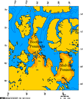
Boothia Peninsula is a large peninsula in Nunavut's northern Canadian Arctic, south of Somerset Island. The northern part, Murchison Promontory, is the northernmost point of mainland Canada.
Graham Island is an uninhabited island in Qikiqtaaluk Region, Nunavut, Canada. A member of the Queen Elizabeth Islands and Canadian Arctic Archipelago, it is located in Norwegian Bay off the coast of Ellesmere Island. Located at 77°25'N 90°30'W it has an area of 1,378 km2 (532 sq mi), 55 kilometres (34 mi) long and 40 kilometres (25 mi) wide. It was named in 1910.

Wales Island is one of the uninhabited Canadian arctic islands in the Qikiqtaaluk Region of Nunavut. Located 1.5 kilometres off the Melville Peninsula, the island is situated in Committee Bay within western Gulf of Boothia. It has an area of 1,137 square kilometres.

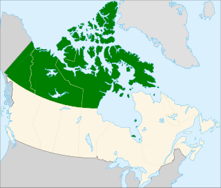
The Gulf of Boothia is a body of water in Nunavut, Canada. Administratively it is divided between the Kitikmeot Region on the west and the Qikiqtaaluk Region on the east. It merges north into Prince Regent Inlet, the two forming a single bay with different names for its parts. It is surrounded by, clockwise, Baffin Island, Fury and Hecla Strait, the Melville Peninsula, the Canadian mainland, the Boothia Peninsula and perhaps Bellot Strait if the Gulf can be said to extend that far north. The south end is Committee Bay, northwest of which are the Simpson Peninsula and Pelly Bay. In addition to its connection to Prince Regent Inlet one can use an icebreaker to go east through the Fury and Hecla Strait, or, with luck, pass the Bellot Strait westward.

Crown Prince Frederik Island is an island in Nunavut, Canada. It is located off the southern coast of western Baffin Island, in the Qikiqtaaluk Region's side of the Gulf of Boothia. It has an area of 401 km2 (155 sq mi).
The Martin Islands are part of the Canadian Arctic Archipelago in the territory of Nunavut. They are located in western Gulf of Boothia near the Boothia Peninsula.
The Hecla and Fury Islands are members of the Canadian Arctic Archipelago in the territory of Nunavut. They are located in western Gulf of Boothia, near the Boothia Peninsula, and southeast of Martin Islands.
The Copeland Islands are members of the Canadian Arctic Archipelago in the territory of Nunavut. They are located in western Gulf of Boothia at the mouth of Thom Bay, east of the Boothia Peninsula. The Martin Islands are to the north; the Hecla and Fury Islands are to the east.

The Astronomical Society Islands are members of the Canadian Arctic Archipelago in the territory of Nunavut. They are located in western Gulf of Boothia at the mouth of Lord Mayor Bay. The group is near the Boothia Peninsula and south of the Copeland Islands.
The Harrison Islands are members of the Canadian Arctic Archipelago in the territory of Nunavut. They are located in western Gulf of Boothia's Pelly Bay, east of the Ross Peninsula. The group lies north of the Arctic Circle, south of the Queen Elizabeth Islands, and southeast of the Astronomical Society Islands.
One of the uninhabited Baffin Island offshore island groups, the Lavoie Islands are located at the head of the Bernier Bay, approximately 80 km (50 mi) from its opening into eastern Gulf of Boothia. The islands are part of the Qikiqtaaluk Region, in the Canadian territory of Nunavut.

The Tasmania Islands are uninhabited islands located in the Kitikmeot Region, Nunavut, Canada. They are located in Franklin Strait, west of the mainland's Boothia Peninsula.
Gibson Island is located in Nunavut's Kitikmeot Region within the northern Canadian Arctic. It is in Franklin Strait, west of the mainland's Boothia Peninsula, and 26.5 km (16.5 mi) southwest of Murchison Promontory.
Susanna Island is an island located in Nunavut's Kitikmeot Region within the northern Canadian Arctic. It is in eastern Gulf of Boothia near the mainland's Boothia Peninsula, and 8.5 km (5.3 mi) southeast of the larger Pouncet Island.
Lady Parry Island is an uninhabited island in Nunavut, Canada. It is located within the Kitikmeot Region's side of the Gulf of Boothia. It is east of the mainland's Boothia Peninsula, northwest of Hecla and Fury Islands.
Sabine Island is an uninhabited island located in Nunavut's Qikiqtaaluk Region within the northern Canadian Arctic. It is in eastern Gulf of Boothia's Committee Bay, south of Wales Island and west of the mainland's Melville Peninsula.
Glen Island is an island in Nunavut, Canada. It is located in the Qikiqtaaluk Region's side of the Gulf of Boothia within Committee Bay. It is northeast of Wales Island and west of the mainland's Melville Peninsula.
Honeyman Island is an irregularly shaped, uninhabited island in Nunavut, Canada. It is located in the Qikiqtaaluk Region's side of the Gulf of Boothia within Committee Bay. It is west of the mainland's Melville Peninsula.
Lord Mayor Bay is an Arctic waterway in Kitikmeot Region, Nunavut, Canada. It is located in the west of the Gulf of Boothia.
Brentford Bay is an Arctic waterway in Kitikmeot Region, Nunavut, Canada. It is located in the west of the Gulf of Boothia.