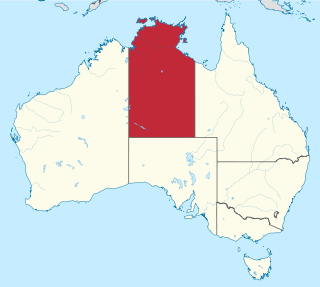
The Northern Territory is a federal Australian territory in north-central Australia. It is the third largest Australian federal division with an area of 1,348,094.3 square kilometres (520,502 sq mi) but the least populous with 245,929 inhabitants as at June 2019. The Northern Territory is divided administratively into 17 Local government areas (LGAs) generally known as Councils who are responsible for providing local government services.

The Cabinet of the Philippines consists of the heads of the largest part of the executive branch of the national government of the Philippines. Currently, it includes the secretaries of 22 executive departments and the heads of other several other minor agencies and offices that are subordinate to the president of the Philippines.
The Local Government Association (LGA) is the national membership body for local authorities in England and Wales. Its core membership is made up of 317 English councils and the 22 Welsh councils through the Welsh Local Government Association.

The Cowra Shire is a local government area in the Central West region of New South Wales, Australia. The Shire is located adjacent to the Lachlan River, the Mid-Western Highway and the Lachlan Way.

The Tiwi Islands Region is a local government area (LGA) of the Northern Territory, Australia. The LGA covers an area of 7,483 square kilometres (2,889 sq mi) and had an estimated population of 2,753 in June 2018, and is governed by the Tiwi Islands Regional Council, formerly Tiwi Islands Shire Council.
Dunukofia is a Local Government Area in Anambra State, South-East Nigeria. Towns that make up the local government are Ukpo, the headquarters; Ifitedunu, Dunukofia Umunnachi, Umudioka, Ukwulu and Nawgu. It shares boundaries with Awka North, Idemili North, Njikoka and Oyi Local Governments.

Fingal is a rural locality in the local government area (LGA) of Break O'Day in the North-east LGA region of Tasmania. The locality is about 56 kilometres (35 mi) south-west of the town of St Helens. The 2016 census recorded a population of 405 for the state suburb of Fingal.
Essien Udim is one of the Annang speaking Local Government Areas in Akwa Ibom State, Nigeria.
Ankpa is a Local Government Area in Kogi State, Nigeria. Its headquarters are in the town of Ankpa on the A233 highway in the west of the area at7°22′14″N7°37′31″E.
Prospect is a residential locality in the local government area (LGA) of Launceston in the Launceston LGA region of Tasmania. The locality is about 8 kilometres (5.0 mi) south of the town of Launceston. The 2016 census recorded a population of 1722 for the state suburb of Prospect. It is a suburb of Launceston.
Demsa is a Local Government Area of Adamawa State, Nigeria with headquarters located in Demsa. Demsa lies on the Benue River.
Misau is a Local Government Area of Bauchi State, Nigeria. Its headquarters are in the town of Misau. The people of Misau are mostly Fulani, and Kanuri tribe.
Guma is a Local Government Area of Benue State, North Central Nigeria. Its headquarters are in the town of Gbajimba.

Akko is a local government area of Gombe, Gombe State, Nigeria. Its headquarters is in Kumo town on the A345 highway south of the state capital Gombe, about 40 km away. Kumo (headquarter) is a cosmopolitan communities of more than 30 differents tribes, ranging from the dominant Fulani tribe to Tangale, Tera, Hausa and other minorities.
Ogbomoso South local government government area is domiciled in Oyo state, South-west geopolitical zone of Nigeria. Its headquarters are located in Arowomole area of Ogbomoso.
Bukkuyum is a Local Government Area in Zamfara State, Nigeria. Its headquarters is in the town of Bukkuyum. In March 2017 more than 300 children died of Lead poisoning from illegal mining site at yar Galma village at12°08′00″N5°28′00″E in the north-west of the area.
Ife South is a Local Government Area in Osun State, Nigeria. Its headquarters are in the town of Ifetedo at 7°11′00″N4°42′00″E.

Local government in the Australian state of Victoria consists of 79 local government areas (LGAs). Also referred to as municipalities, Victorian LGAs are classified as cities (34), shires (38), rural cities (6) and boroughs (1). In general, an urban or suburban LGA is called a city and is governed by a City Council, while a rural LGA covering a larger rural area is usually called a shire and is governed by a Shire Council. Local councils have the same administrative functions and similar political structures, regardless of their classification.
The Kwara State Executive Council is the highest formal governmental body that plays important roles in the Government of Kwara State headed by the Governor of Kwara State. It consists of the Deputy Governor, Secretary to the State Government, Chief of Staff, Commissioners who preside over ministerial departments, and the Governor's special aides.

Bolanle "Bola" Olukoju is a Nigerian public relations expert, entrepreneur, community organiser, and technocrat. She currently serves as the Honourable Commissioner for Communications in Kwara State and is a member of the State Executive Council under Governor AbdulRahman AbdulRazaq (CON). She was sworn into office on 4 September 2023.