
Athens is the capital and largest city of Greece. A major coastal urban area in the Mediterranean, Athens is also the capital of the Attica region and is the southernmost capital on the European mainland. With its urban area's population numbering over three and a quarter million, it is the eighth largest urban area in the European Union. The Municipality of Athens, which constitutes a small administrative unit of the entire urban area, had a population of 643,452 (2021) within its official limits, and a land area of 38.96 km2 (15.04 sq mi).
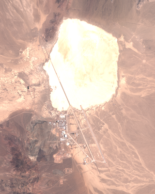
Area 51 is the common name of a highly classified United States Air Force (USAF) facility within the Nevada Test and Training Range. A remote detachment administered by Edwards Air Force Base, the facility is officially called Homey Airport or Groom Lake. Details of its operations are not made public, but the USAF says that it is an open training range, and it is commonly thought to support the development and testing of experimental aircraft and weapons systems. The USAF and CIA acquired the site in 1955, primarily for flight testing the Lockheed U-2 aircraft.

The West Bank, so called due to its location relative to the Jordan River, is the larger of the two Palestinian territories that comprise the State of Palestine. A landlocked territory near the coast of the Mediterranean Sea in the Levant region of West Asia, it is bordered by Jordan and the Dead Sea to the east and by Israel to the south, west, and north. Since 1967, the territory has been occupied by Israel and in 2024 an advisory opinion of the International Court of Justice determined that the occupation is illegal under international law.

A ZIP Code is a system of postal codes used by the United States Postal Service (USPS). The term ZIP was chosen to suggest that the mail travels more efficiently and quickly when senders use the code in the postal address.

Johannesburg is the most populous city in South Africa with 4,803,262 people, and is classified as a megacity; it is one of the 100 largest urban areas in the world. It is the provincial capital of Gauteng, the wealthiest province in South Africa. Johannesburg is the seat of the Constitutional Court, the highest court in South Africa. Most of the major South African companies and banks have their head offices in Johannesburg. The city is located within the mineral-rich Witwatersrand hills, the epicentre of the international-scale mineral, gold and (specifically) diamond trade.

Glasgow is the most populous city in Scotland, located on the banks of the River Clyde in west central Scotland. The city is the third-most-populous city in the United Kingdom and the 27th-most-populous city in Europe. In 2022, it had an estimated population as a defined locality of 632,350 and anchored an urban settlement of 1,028,220. The economy of Glasgow is the largest of any city or region in Scotland's economy, and the city's economic strength is reflected in its membership of the Core Cities Group.

A metropolitan area or metro is a region consisting of a densely populated urban agglomeration and its surrounding territories which are sharing industries, commercial areas, transport network, infrastructures and housing. A metropolitan area usually comprises multiple principal cities, jurisdictions and municipalities: neighborhoods, townships, boroughs, cities, towns, exurbs, suburbs, counties, districts and even states and nations in areas like the eurodistricts. As social, economic and political institutions have changed, metropolitan areas have become key economic and political regions.
In the United States, a metropolitan statistical area (MSA) is a geographical region with a relatively high population density at its core and close economic ties throughout the region. Such regions are not legally incorporated as a city or town would be and are not legal administrative divisions like counties or separate entities such as states. As a result, sometimes the precise definition of a given metropolitan area will vary between sources. The statistical criteria for a standard metropolitan area were defined in 1949 and redefined as a metropolitan statistical area in 1983.

Postal codes used in the United Kingdom, British Overseas Territories and Crown dependencies are known as postcodes. They are alphanumeric and were adopted nationally between 11 October 1959 and 1974, having been devised by the General Post Office . The system uses alphanumeric codes to designate geographic areas. A full postcode, also known as a "postcode unit", identifies a group of addresses or a major delivery point. It consists of an outward code and inward code. The outward code indicates the area and district, while the inward code specifies the sector and delivery point, typically encompassing about 15 addresses.

An unincorporated area is a region that is not governed by a local municipal corporation. There are many unincorporated communities and areas in the United States and Canada.

The Chicago metropolitan area, also referred to as the Greater Chicago Area and Chicagoland, is the largest metropolitan statistical area in the U.S. state of Illinois, and the Midwest, containing the City of Chicago along with its surrounding suburbs and satellite cities. Encompassing 10,286 square mi (28,120 km2), the metropolitan area includes the city of Chicago, its suburbs and hinterland, that span 13 counties across northeast Illinois and northwest Indiana. The MSA had a 2020 census population of 9,618,502 and the combined statistical area, which spans 19 counties and additionally extends into southeast Wisconsin, had a population of nearly 10 million people. The Chicago area is the third largest metropolitan area in the United States and the fourth largest metropolitan area in North America, and the largest in the Great Lakes megalopolis. Its urban area is one of the forty largest in the world.
A telephone numbering plan is a type of numbering scheme used in telecommunication to assign telephone numbers to subscriber telephones or other telephony endpoints. Telephone numbers are the addresses of participants in a telephone network, reachable by a system of destination code routing. Telephone numbering plans are defined in each of the administrative regions of the public switched telephone network (PSTN) and in private telephone networks.

An urban area is a human settlement with a high population density and an infrastructure of built environment. This is the core of a metropolitan statistical area in the United States, if it contains a population of more than 50,000.

The Schengen Area is an area encompassing 29 European countries that have officially abolished border controls at their mutual borders. Being an element within the wider area of freedom, security and justice policy of the European Union (EU), it mostly functions as a single jurisdiction under a common visa policy for international travel purposes. The area is named after the 1985 Schengen Agreement and the 1990 Schengen Convention, both signed in Schengen, Luxembourg.

The San Francisco Bay Area, commonly known as the Bay Area, is a region of California surrounding and including the San Francisco Bay. The Association of Bay Area Governments defines the Bay Area as including the nine counties that border the estuaries of San Francisco Bay, San Pablo Bay, and Suisun Bay: Alameda, Contra Costa, Marin, Napa, San Mateo, Santa Clara, Solano, Sonoma, and San Francisco. Other definitions may be either smaller or larger, and may include neighboring counties which are not officially part of the San Francisco Bay Area, such as the Central Coast counties of Santa Cruz, San Benito, and Monterey, or the Central Valley counties of San Joaquin, Merced, and Stanislaus. The Bay Area is known for its natural beauty, prominent universities, technology companies, and affluence. The Bay Area contains many cities, towns, airports, and associated regional, state, and national parks, connected by a complex multimodal transportation network.

