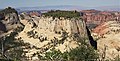
Inclined Temple

Last updated
Inclined Temple
Inclined Temple from Zion West Rim Trail.jpg
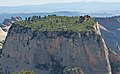
East aspect, from West Rim Trail
Highest point
Elevation 7,150 ft (2,180 m) [1]
Prominence 630 ft (190 m) [1]
Parent peak Point 7370 (7,370 ft) [1]
Isolation 0.92 mi (1.48 km) [1]
Coordinates 37°16′46″N113°00′25″W / 37.2794440°N 113.0069035°W / 37.2794440; -113.0069035 < [2]
Geography
USA Utah relief location map.svg
Red triangle with thick white border.svg
Inclined Temple
Location in Utah
Usa edcp relief location map.png
Red triangle with thick white border.svg
Inclined Temple
Inclined Temple (the United States)
Location Zion National Park
Washington County, Utah
United States
Parent range Colorado Plateau
Topo map USGS The Guardian Angels
Geology
Age of rock Jurassic
Type of rock Navajo sandstone
Climbing
Easiest route class 5+ climbing [1]

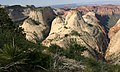
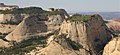
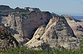
Inclined Temple is a remote 7,150-foot (2,180 meter) elevation summit located in Zion National Park, in Washington County of southwest Utah, United States. [2]

Contents

Description

Inclined Temple, a mesa-like formation composed of Navajo Sandstone, is situated 7.0 mi (11.3 km) north of Springdale, Utah. Its nearest neighbor is Ivins Mountain, one half mile to the north, and South Guardian Angel is set approximately three miles to the west-northwest. Its name was officially adopted in 1935 by the U.S. Board on Geographic Names. [2] This geographical feature is so named because its broad top has a decided incline. [2] Precipitation runoff from this mountain drains into North Creek, a tributary of the Virgin River.

Climate

Spring and fall are the most favorable seasons to visit Inclined Temple. According to the Köppen climate classification system, it is located in a Cold semi-arid climate zone, which is defined by the coldest month having an average mean temperature below 32 °F (0 °C), and at least 50% of the total annual precipitation being received during the spring and summer. This desert climate receives less than 10 inches (250 millimeters) of annual rainfall, and snowfall is generally light during the winter. [3]

See also

Related Research Articles

<span class="mw-page-title-main">Bee Hive (peak)</span> Mountain in Zion National Park, Utah, USA

Bee Hive is a 6,904 feet (2,104 m) Navajo Sandstone mountain in Zion National Park in Washington County, Utah, United States, that is part of the Towers of the Virgin.

<span class="mw-page-title-main">Mount Spry</span> Mountain summit in southwest Utah, US

Mount Spry is a small 5,720-ft elevation mountain summit made of Navajo Sandstone located in Zion National Park, in Washington County of southwest Utah, United States. Officially named in 1934, it honors William Spry (1864-1929), the third governor of Utah. The nearest higher peak is The East Temple, 0.34 miles (0.55 km) to the east. Precipitation runoff from the mountain drains into tributaries of the North Fork Virgin River.

<span class="mw-page-title-main">The East Temple</span> Mountain in the state of Utah

The East Temple is a prominent 7,709 feet (2,350 m) summit composed of Navajo Sandstone in Zion National Park, in Washington County of southwest Utah, United States. It is one of the notable landmarks in the park. The nearest neighbor is Twin Brothers, one-half mile to the north, and the nearest higher peak is The West Temple, 3.85 miles (6.20 km) to the west-southwest. The mountain is situated 1.8 miles northeast of the park headquarters, at the confluence of Pine Creek and the North Fork Virgin River. This feature's name was applied by John Wesley Powell during his explorations in 1872, and was officially adopted in 1934 by the U.S. Board on Geographic Names. The first ascent was made in 1937 by Glen Dawson, Dick Jones, Homer Fuller, Wayland Gilbert, and Jo Momyer.

<span class="mw-page-title-main">The West Temple</span> Mountain in the state of Utah

The West Temple is a prominent 7,810-foot mountain summit composed of Navajo Sandstone in Zion National Park in Washington County of Utah, United States. This, the highest feature in Zion Canyon, was originally called "Temp-o-i-tin-car-ur" meaning "Mountain without a trail" by the Paiute people. It was called Steamboat Mountain by local Mormon settlers before 1934, when the USGS officially changed it to its present name, which was applied by John Wesley Powell during his explorations in 1872. West Temple is situated two miles northwest of Springdale, Utah, one mile northeast of Mount Kinesava, and two miles west of the park headquarters. It is one of the notable landmarks in the park. The nearest higher peak is Windy Peak, 10.46 miles (16.83 km) to the north. Precipitation runoff from the mountain drains into tributaries of the Virgin River.

<span class="mw-page-title-main">The Watchman (Utah)</span> Mountain in Zion National Park

The Watchman is a 6,545-foot (1,995 m) sandstone mountain summit located in Zion National Park, in Washington County of southwest Utah, United States.

<span class="mw-page-title-main">The Sentinel (Zion National Park)</span> Mountain in the state of Utah

The Sentinel is a 7,120+ ft elevation Navajo Sandstone summit located near the Court of the Patriarchs in Zion National Park, in Washington County of southwest Utah, United States, that is part of the Towers of the Virgin. The national park map lists the elevation as 7,157-feet.

<span class="mw-page-title-main">Cathedral Mountain (Zion National Park)</span> Mountain in the state of Utah

Cathedral Mountain is a 6,930-foot (2,110 m) elevation Navajo Sandstone summit located in Zion National Park, in Washington County of southwest Utah, United States.

<span class="mw-page-title-main">Observation Point (Zion National Park)</span>

Observation Point is a 6,507-foot (1,983 m) elevation Navajo Sandstone feature located in Zion National Park, in Washington County of southwest Utah, United States. Observation Point is situated at the north end of Zion Canyon, towering 2,100 feet above the canyon floor and the North Fork of the Virgin River which drains precipitation runoff from this viewpoint. A popular 8-mile round-trip trail climbs from the Weeping Rock trailhead along Zion Canyon Road to reach the top. Neighbors visible from the point include The Great White Throne, Cathedral Mountain, Angels Landing, and Cable Mountain. This geographical feature's name was officially adopted in 1934 by the U.S. Board on Geographic Names.

<span class="mw-page-title-main">The Organ (Zion National Park)</span>

The Organ is a 5,080-foot (1,550 m) elevation Navajo Sandstone summit located in Zion National Park, in Washington County of southwest Utah, United States. The Organ is situated in the Big Bend at the north end of Zion Canyon, rising 700 feet above the canyon floor and the North Fork of the Virgin River which drains precipitation runoff from this rock. Neighbors include The Great White Throne, Cathedral Mountain, Angels Landing, Observation Point, and Cable Mountain. The Organ is believed to have been named by Claud Hirschi and Ethelbert Bingham, residents of Rockville, on their 1916 trip with Methodist Minister Frederick Vining Fisher, who also named geographical formations in Zion. This geographical feature's descriptive name was officially adopted in 1934 by the U.S. Board on Geographic Names.

<span class="mw-page-title-main">Altar of Sacrifice</span> Sandstone mountain in the state of Utah

Altar of Sacrifice is a 7,505-foot (2,288 m) Navajo Sandstone mountain in Zion National Park in Washington County, Utah, United States, that is part of the Towers of the Virgin.

<span class="mw-page-title-main">Mountain of the Sun</span> Mountain in the state of Utah

Mountain of the Sun is a 6,722-foot (2,049 m) elevation Navajo Sandstone summit located in Zion National Park, in Washington County of southwest Utah, United States. Mountain of the Sun is situated immediately east of Court of the Patriarchs, and south of Zion Lodge, towering 2,500 feet above the lodge and the floor of Zion Canyon. It is set on the east side of the North Fork of the Virgin River which drains precipitation runoff from this mountain. Its neighbors include The Sentinel, Mount Spry, The East Temple, and Mount Moroni. This feature's name was officially adopted in 1934 by the U.S. Board on Geographic Names.

<span class="mw-page-title-main">Lady Mountain</span> Mountain in the state of Utah

Lady Mountain is a 6,945-foot (2,117 m) elevation Navajo Sandstone summit located in Zion National Park, in Washington County of southwest Utah, United States.

<span class="mw-page-title-main">Mount Majestic (Utah)</span> Mountain in the state of Utah

Mount Majestic, also known as Majestic Mountain, is a 6,956-foot (2,120 m) elevation Navajo Sandstone double-summit mountain located in Zion National Park, in Washington County of southwest Utah, United States.

<span class="mw-page-title-main">Twin Brothers</span> Mountain in the state of Utah

Twin Brothers is a 6,863-foot (2,092 m) Navajo Sandstone mountain in Zion National Park in Washington County, Utah, United States.

<span class="mw-page-title-main">Ivins Mountain</span> Mountain in the American state of Utah

Ivins Mountain is a remote 7,019-foot (2,139 m) Navajo Sandstone summit located in Zion National Park, in Washington County of southwest Utah, United States.

<span class="mw-page-title-main">South Guardian Angel</span> Mountain in the American state of Utah

South Guardian Angel is a 7,140-foot (2,180 m) summit located in Zion National Park, in Washington County of southwest Utah, United States.

<span class="mw-page-title-main">The Sundial (Zion National Park)</span> Sandstone mountain in the state of Utah

The Sundial is a 7,590-foot (2,310-meter) elevation white Navajo Sandstone summit located in Zion National Park, in Washington County of southwest Utah, United States.

<span class="mw-page-title-main">The Witch Head</span> Sandstone mountain in the state of Utah

The Witch Head is a 7,340-foot (2,240 m) white Navajo Sandstone mountain in Zion National Park in Washington County, Utah, United States, that is part of the Towers of the Virgin.

<span class="mw-page-title-main">Deertrap Mountain</span> Mountain in Washington County, Utah

Deertrap Mountain is a 6,837-foot (2,084 m) mountain in Zion National Park in Washington County, Utah, United States.

<span class="mw-page-title-main">Eagle Crags</span> Mountain in the American state of Utah

Eagle Crags is a 6,380-foot (1,940 m) elevation summit located in the Canaan Mountain Wilderness of Washington County in southwest Utah, United States.

References

  1. 1 2 3 4 5 "Inclined Temple - 7,150' UT". listsofjohn.com. Retrieved 2020-09-09.
  2. 1 2 3 4 U.S. Geological Survey Geographic Names Information System: Inclined Temple
  3. "Zion National Park, Utah, USA - Monthly weather forecast and Climate data". Weather Atlas. Archived from the original on January 27, 2019. Retrieved 31 August 2020.