Ingush okrug

Last updated
Ingush okrug
Ингушевскiй округъ
Map of Terek oblast (Russian empire) 1862.png
Location in the Terek Oblast in green
Country Russian Empire
Viceroyalty Caucasus
Oblast Terek
Established1862
Abolished1871
Capital Vladikavkaz
Area
  Total1,526.14 km2 (589.25 sq mi)
Population
 (1870)
  Total32 315
   Rural
100.00%

Ingush okrug [lower-alpha 1] was a district ( okrug ) of the Terek Oblast of the Caucasus Viceroyalty of the Russian Empire. The area of the Ingushskiy okrug made up part of the North Caucasian Federal District of Russia.

Contents

Established in 1862 as a military district of the Terek Oblast, it existed for approximately 9 years. In 1865 the Karabulakskiy Uchastok was abolished due to the resettlement of the majority of its population (Karabulaks). In 1867, two societies, Merzhoy and Akkins, were ceded to the neighboring Argunskiy Okrug. Finally, in 1871, Ingushskiy Okrug was combined with the Ossetinskiy okrug into a new district, Vladikavkazsky okrug .

Geography

It was located in the central part of the North Caucasus in the basin of the Terek, Sunzha, Assa and Fortanga rivers, covering the territory of modern Ingushetia, parts of the Mozdok and Prigorodny regions of North Ossetia, Sernovodsky and parts of the Achkhoy-Martanovsky regions of the Chechen Republic. [1]

It bordered in the west with the Ossetinskiy Okrug  [ ru ], in the northwest with the Kabardinskiy Okrug  [ ru ], in the north with the Stavropol Governorate, in the east with the Chechenskiy Okrug  [ ru ], in the southeast with the Argunskiy Okrug  [ ru ], in the south along the Caucasus Range with the Tiflis Governorate.

History

Ingushskiy Okrug on the Road map of the Caucasus region in 1853. Ingushskii okrug na Dorozhnoi karte Kavkazskogo kraia 1853 g. (186(4).jpg
Ingushskiy Okrug on the Road map of the Caucasus region in 1853.
Ingushskiy Okrug on the map of the Caucasus region, 1869. Ingushskii okrug na karte Kavkazskogo kraia (1869 g.).jpg
Ingushskiy Okrug on the map of the Caucasus region, 1869.

Background

Up until the 1860s, the mountaineers in the North Caucasus were subordinated to the military authorities of the Left (North-Eastern Caucasus) and Right (North-Western Caucasus) flanks of the Caucasian Line. Only in the Stavropol Governorate was there a civil administration. [2]

Establishment

In 1862, Terek Oblast was divided into three districts ( otdel ), that is, Western, Middle and Eastern. To the former belonged the newly created Ingushskiy Okrug [3] [4] (also referred as the Voenno-Ingushskiy Okrug). [5]

The administrative center of the Ingushskiy Okrug, together with the Ossetian Okrug, was Vladikavkaz. The Okrug consisted of three uchastoks: Nazranovskiy, Psedakhskiy, Gorsky and Karabulakskiy. [6] [1] Significant lands of the plain of Ingushetia in 1864-1865, after the construction of Cossack villages on them, were directly subordinated to the Terek Cossack Host. In 1866, the territory of the Meredzhin and Akkin societies was separated from the Gorskiy Uchastok of the Ingushskiy Okrug and subordinated to the administration of the Argunskiy Okrug. [7] [8] [lower-alpha 2]

In 1865, after the resettlement of Karabulaks to Turkey, Karabulakskiy Uchastok was abolished and its lands were ceded to nearby Cossack stanitsas . [10]

On February 2, 1870, a project was approved to establish an agricultural farm and school in the Ingush district. [11]

In 1871, the Ingushskiy Okrug was disestablished when, together with the Cossack villages on the Sunzha, it was merged with the Ossetinskiy Okrug into one Vladikavkazsky Okrug. [12]

Administrative divisions

In administrative terms, initially in 1862 Ingushkiy Okrug was divided into 4 subcounties ( uchastoks ) and the lands of the villages on the Sunzha subordinate to the Terek Cossack army. However, in 1865 the number of sites was reduced to three. The subcounties of the Ingushskiy okrug were as follows:

Name1868 population [13]
Nazranovskiy Uchastok (Назрановскій участокъ)17,339
Psedakhskiy Uchastok (Пседахскій участокъ)6812
Gorskiy Uchastok (Горскій участокъ)5763
Name1865 population
Karabulakskiy Uchastok [lower-alpha 3] (Карабулакскій участокъ)5201

Notes

    • Ingush: Гӏалгӏай окре, romanized: Ghalghai okre.
  1. Due to them belonging to the same nation as the locals (Chechens) and geographically closer to the central governance of the Okrug. [9]
  2. 1 2 In 1865, the Karabulakskiy Uchastok of the Ingushskiy Okrug was liquidated, and its lands were divided between the Sunzha Cossacks and the Chechenskiy Okrug. [6] [1]

Related Research Articles

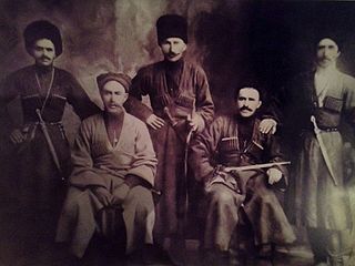
Ingush, historically known as Durdzuks, Gligvi and Kists, are a Northeast Caucasian ethnic group mainly inhabiting the Republic of Ingushetia in central Caucasus, but also inhabitanting Prigorodny District and town of Vladikavkaz of modern day North-Ossetia. The Ingush are predominantly Sunni Muslims and speak the Ingush language.

Yalkharoy is a rural locality in Urus-Martanovsky District of the Republic of Chechnya, Russia.

<span class="mw-page-title-main">Orstkhoy</span> Historical ethnoterritorial society among the Ingush and Chechen people

The Orstkhoy, historically commonly known under their exonyms: Karabulaks, Balsu, Baloy, are a historical ethnoterritorial society among the Chechen and Ingush peoples. Their homeland is in the upper reaches of the Assa and Fortanga rivers in the historical region of Orstkhoy-Mokhk. In the tradition of the Chechen ethno-hierarchy, it is considered one of the nine historical Chechen tukkhums, in the Ingush tradition as one of the seven historical Ingush shahars.

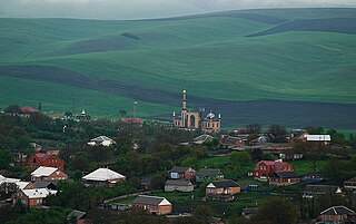
Galashki is a rural locality in Sunzhensky District of the Republic of Ingushetia, Russia, located on the left bank of the Sunzha River near the border with the Republic of North Ossetia–Alania. Its population was about 9,000 people in 2009. Galashki forms the municipality of the rural settlement of Galashki as the only settlement in its composition.

<span class="mw-page-title-main">Simsim</span> Middle Ages European kingdom

Simsim was either a historical region or kingdom in the North Caucasus during the Middle Ages, existing in the 14th century. Predominantly localized roughly in Eastern Chechnya (Ichkeria), with some also connecting part of Kumyk Plain. Simsim is also localized in both Chechnya and Ingushetia. Its name may have been derived from the Chechen village of Simsir. However, according to folklore, the King Gayur-khan was chosen as the leader of all Chechens by the Mehk-Khel. In its later years it allied itself with the Golden Horde before being destroyed in 1395 by Timurlane, which was recorded in Zafarnama by Nizam al-Din Shami and the Zafarnama by Sharaf ad-Din Ali Yazdi.

<span class="mw-page-title-main">Fappi</span> Historical region in Ingushetia

Fappi or Fappi mokhk, exonym: Kistetia, is a historical region in Ingushetia. Fappi is the territory of historical settlement of the Fyappiy society.

<span class="mw-page-title-main">Galashians</span> Ingush society

Galashians, were a historical Ingush ethnoterritorial society, which formed in the middle of the 18th century. The name comes from the village of Galashki, which is geographically located in the very center of the society. Galashians were located in the middle and lower reaches of the river Assa and the basin of the river Fortanga.

Ingush societies or shahars were ethnoterritorial associations of the Ingush based on the geographical association of several villages and intended for conditional administrative-territorial delimitation of the Ingush ethnic group. The formation and functioning of most of them dates back to the late Middle Ages. During this period, their boundaries, number and names changed.

<span class="mw-page-title-main">Zaur (village)</span> Historical place (village)

Zaur or Zaurovo was an Ingush village that existed in the 18th–19th centuries on the right bank of the Terek River and in the Tarskoye Valley.

<span class="mw-page-title-main">Nazranians</span> Ingush society

The Nazranians were a historical Ingush ethnoterritorial subethnic group (society) which inhabited modern day Nazranovsky District and Prigorodny District.

<span class="mw-page-title-main">Dzherakh</span> Ingush society

The Dzherakh, also spelled Jerakh, historically also known as Erokhan people, were a historical Ingush ethnoterritorial society, today a tribal organization/clan (teip), that was formed in the Dzheyrakhin gorge, as well as in the area of the lower reaches of the Armkhi River and the upper reaches of the Terek River.

<i>Torshkhoy</i> Ingush clan (teip)

Torshkhoy, also known in Ingush folklore as Them-Thoarshkhoy, is an Ingush clan (teip) which belongs to the Fyappin society. The ancestral auls of Torshkhoy are Tyarsh and Falkhan. A small number of representatives of the teip live in Aukh, where they are known under the name Vyappiy.

<span class="mw-page-title-main">Tsorins</span> Ingush society

Tsorins, Tsori, also Ghalghaï, were a historical Ingush ethnoterritorial society that was located in mountainous Ingushetia in the region of river Guloykhi. The center of the society was Tsori from which it got its name. Tsorin society, like the Khamkhin society, was formed from the former "Galgaï society" as a result of the transfer (appearance) of rural government to the village Tsori.

Arshty is a rural locality in Sunzhensky District of the Republic of Ingushetia, Russia, located on left bank of the river Arshtynka near the border with the Republic of Chechnya. It forms the municipality of the rural settlement of Arshty as the only settlement in its composition.

<span class="mw-page-title-main">Ekazhevo</span> Rural locality in Ingushetia

Ekazhevo is a rural locality in Nazranovsky District of the Republic of Ingushetia, Russia. It forms the municipality of the rural settlement of Ekazhevo as the only settlement in its composition.

Khay is a non-residential rural locality in Achkhoy-Martanovsky District of the Republic of Chechnya, Russia.

<span class="mw-page-title-main">Meredzhi (village)</span> Rural locality in Chechnya

Meredzhi is a non-residential rural locality in Galanchozhsky District of the Republic of Chechnya, Russia.

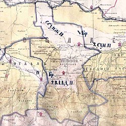
Gorsky Uchastok was a territorial-administrative unit (uchastok) of the Ingushskiy Okrug of the Terek Oblast of the Russian Empire. The area of the Gorsky Uchastok made up Dzheyrakhsky and part of the Sunzhensky Districts of Ingushetia.

Karabulakskiy Uchastok was a territorial-administrative unit (uchastok) of the Ingushskiy Okrug of the Terek Oblast of the Russian Empire. The area of the Gorsky Uchastok made up Sunzhensky District of Ingushetia and Achkhoy-Martanovsky District of Chechnya.

<span class="mw-page-title-main">Erzi (village)</span> Rural locality in Ingushetia

Erzi is a medieval village (aul) in the Dzheyrakhsky District of Ingushetia. It is part of the rural settlement of Olgeti. The entire territory of the settlement is included in the Dzheyrakh-Assa State Historical-Architectural and Natural Museum-Reserve and is under state protection.

References

  1. 1 2 3 Албогачиева 2015, p. 177.
  2. Долгиева et al. 2013, p. 283.
  3. Ахмадов & Хасмагомадов 2005, p. 35.
  4. Шнирельман 2006, p. 21.
  5. Сборник документов и материалов 2020.
  6. 1 2 Албогачиева, Мартазанов & Соловьева 2013, p. 177.
  7. 1 2 Грабовскій 1870, p. 115.
  8. 1 2 Дубровин 1871, p.  381.
  9. "Горскій участокъ Ингушевскаго округа — въ 1865 году" [Mountain Uchastok of the Ingushevskiy Okrug – in 1865]. Терскія Вѣдомости. No. 21. Владикавказъ. 21 May 1868. p. 83 (3 as PDF).
  10. Арапов et al. 2007, p. 219.
  11. Якуб, Патиев (2019-01-31). "События февраля" [February events]. Сердало (in Russian). No. 13 (12148). Archived from the original on 2019-11-22.
  12. Долгиева et al. 2013, p. 236.
  13. Сборник свѣдѣній о кавказскихъ горцахъ 1868, p.  6–7.

Bibliography

English sources

Russian sources