
Eswatini, officially the Kingdom of Eswatini and also known by its former official name Swaziland, is a landlocked country in Southern Africa. It is bordered by Mozambique to its northeast and South Africa to its north, west, south, and southeast. At no more than 200 km (120 mi) north to south and 130 km (81 mi) east to west, Eswatini is one of the smallest countries in Africa; despite this, its climate and topography are diverse, ranging from a cool and mountainous highveld to a hot and dry lowveld.
Artifacts indicating human activity dating back to the early Stone Age have been found in the Kingdom of Eswatini. The earliest known inhabitants of the region were Khoisan hunter-gatherers. Later, the population became predominantly Nguni during and after the great Bantu migrations. People speaking languages ancestral to the current Sotho and Nguni languages began settling no later than the 11th century. The country now derives its name from a later king named Mswati II. Mswati II was the greatest of the fighting kings of Eswatini, and he greatly extended the area of the country to twice its current size. The people of Eswatini largely belong to a number of clans that can be categorized as Emakhandzambili, Bemdzabu, and Emafikamuva, depending on when and how they settled in Eswatini.

KwaZulu-Natal is a province of South Africa that was created in 1994 when the Zulu bantustan of KwaZulu and Natal Province were merged. It is located in the southeast of the country, with a long shoreline on the Indian Ocean and sharing borders with three other provinces and the countries of Mozambique, Eswatini and Lesotho. Its capital is Pietermaritzburg, and its largest city is Durban. It is the second-most populous province in South Africa, with slightly fewer residents than Gauteng.
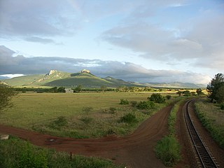
Hlathikulu Forest is a coastal scarp forest in the Lebombo Mountains of South Africa, between Ingwavuma and the Pongola Gorge. The forest is also known as the Gwaliweni Forest. The forest is part of the IUCN's Maputaland Centre of Plant Endemism

The Maputo River, also called Great Usutu River, Lusutfu River, or Suthu River, is a river in South Africa, Eswatini, and Mozambique. The name Suthu refers to Basotho people who lived near the source of the river, but were attacked and displaced by Swazis. It is also said to mean 'dark brown', a description of the river's muddy water.

Pachypodium saundersii, the kudu lily, is a succulent plant of the family Apocynaceae. It was named in honour of Sir Charles James Renault Saunders (1857–1931), the Natal Province civil servant and casual plant collector.
The Lubombo Transfrontier Conservation Area was born out of the Peace Park Foundation’s vision to establish a network of transfrontier conservation areas in southern Africa. It straddles the border between South Africa’s KwaZulu-Natal province, southern Mozambique, and Eswatini.

KwaZulu was a semi-independent bantustan in South Africa, intended by the apartheid government as a homeland for the Zulu people. The capital was moved from Nongoma to Ulundi in 1980.
Mkuze, also named Mkhuze or uMkhuze is a small town in Northern KwaZulu-Natal, South Africa. It is located approximately 350 km from the city of Durban. It is along the N2 road en route to Johannesburg, Eswatini and Mozambique; between the Mkuze River and Intaba Yemikhovu. Mkuze is some distance from other small towns such as Hluhluwe (50 km), Nongoma (76 km), Pongola (65 km), and Jozini (25 km). Mkuze is the seat of Umkhanyakude District Municipality.
Mseleni is a small settlement in Umhlabuyalingana Maputaland, northern KwaZulu-Natal, South Africa. It is situated not far away from the small town of Mbazwana. It is divided into 2 small izigodi namely KwaJobe and KwaNhlamvu, ruled under the Authority of Nkosi J Nxumalo of Mabaso Tribal Authority.
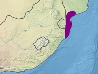
The Maputaland coastal forest mosaic is a subtropical moist broadleaf forest ecoregion on the Indian Ocean coast of Southern Africa. It covers an area of 29,961 square kilometres (11,568 sq mi) in southern Mozambique, Eswatini, and the KwaZulu-Natal Province of South Africa. Mozambique's capital Maputo lies within the ecoregion.
Young Heroes is a charity, based in Mbabane, Swaziland. With a focus on orphaned and vulnerable children and their elderly caretakers, Young Heroes directly addresses the HIV/AIDS epidemic in Swaziland — the nation with the world’s highest rate of infection — on three fronts: education and prevention; healthcare; and impact mitigation/poverty reduction.

uPhongolo Municipality is a local municipality within the northern area of the Zululand District Municipality, in the KwaZulu-Natal province of South Africa.
HIV/AIDS in Eswatini was first reported in 1986 but has since reached epidemic proportions. As of 2016, Eswatini had the highest prevalence of HIV among adults aged 15 to 49 in the world (27.2%).

The Maputaland-Pondoland-Albany Hotspot (MPA) is a biodiversity hotspot, a biogeographic region with significant levels of biodiversity, in Southern Africa. It is situated near the south-eastern coast of Africa, occupying an area between the Great Escarpment and the Indian Ocean. The area is named after Maputaland, Pondoland and Albany. It stretches from the Albany Centre of Plant Endemism in the Eastern Cape Province of South Africa, through the Pondoland Centre of Plant Endemism and KwaZulu-Natal Province, the eastern side of Eswatini and into southern Mozambique and Mpumalanga. The Maputaland Centre of Plant Endemism is contained in northern KwaZulu-Natal and southern Mozambique.

Maputaland is a natural region of Southern Africa. It is located in the northern part of the province of KwaZulu-Natal, South Africa between Eswatini and the coast. In a wider sense it may also include the southernmost region of Mozambique. The bird routes and coral reefs off the coast are major tourist attractions.

The Ngwavuma is a river in Eswatini and KwaZulu-Natal Province in southern Africa. It is also known as the Inguavuma, Ingwavuma, Ingwovuma, and Nggwavuma, and is one of the five major rivers in Eswatini. It arises in southwestern Eswatini and flows eastward. It is a tributary of the Pongola River.

Encephalartos senticosus is a species of cycad in the family Zamiaceae native to the Lebombo Mountains of Mozambique, Eswatini (Swaziland), and the KwaZulu-Natal province of South Africa. Prior to its description in 1996, Encephalartos senticosus had been confused with the closely related and sympatric Encephalartos lebomboensis. Both species are commonly known as the Lebombo cycad.
The Health in Eswatini is poor and four years into the United Nations sustainable development goals, Eswatini seems unlikely to achieve goal on health. As a result of 63% poverty prevalence, 27% HIV prevalence, and poor health systems, maternal mortality rate is a high 389/100,000 live births, and under 5 mortality rate is 70.4/1000 live births resulting in a life expectancy that remains amongst the lowest in the world. Despite significant international aid, the government fails to adequately fund the health sector. Nurses are now and again engaged in demonstrations over poor working conditions, drug stock outs, all of which impairs quality health delivery. Despite tuberculosis and AIDS being major causes of death, diabetes and other non-communicable diseases are on the rise. Primary health care is relatively free in Eswatini save for its poor quality to meet the needs of the people. Road traffic accidents have increased over the years and they form a significant share of deaths in the country.


