
South Africa occupies the southern tip of Africa, its coastline stretching more than 2,850 kilometres from the desert border with Namibia on the Atlantic (western) coast southwards around the tip of Africa and then northeast to the border with Mozambique on the Indian Ocean. The low-lying coastal zone is narrow for much of that distance, soon giving way to a mountainous escarpment that separates the coast from the high inland plateau. In some places, notably the province of KwaZulu-Natal in the east, a greater distance separates the coast from the escarpment. Although much of the country is classified as semi-arid, it has considerable variation in climate as well as topography. The total land area is 1,220,813 km2 (471,359 sq mi). It has the 23rd largest Exclusive Economic Zone of 1,535,538 km2 (592,875 sq mi).

KwaZulu-Natal is a province of South Africa that was created in 1994 when the Zulu bantustan of KwaZulu and Natal Province were merged. It is located in the southeast of the country, with a long shoreline on the Indian Ocean and sharing borders with three other provinces and the countries of Mozambique, Eswatini and Lesotho. Its capital is Pietermaritzburg, and its largest city is Durban. It is the second-most populous province in South Africa, with slightly fewer residents than Gauteng.
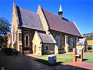
Pietermaritzburg is the capital and second-largest city in the province of KwaZulu-Natal, South Africa. It was founded in 1838 and is currently governed by the Msunduzi Local Municipality. Its Zulu name umGungundlovu is the name used for the district municipality. Pietermaritzburg is popularly called Maritzburg in Afrikaans, English and Zulu alike, and often informally abbreviated to PMB. It is a regionally important industrial hub, producing aluminium, timber and dairy products, as well as the main economic hub of Umgungundlovu District Municipality. The public sector is a major employer in the city due to local, district and provincial governments located here.
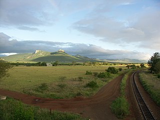
The Lebombo Mountains, also called Lubombo Mountains, are an 800 km-long (500 mi), narrow range of mountains in Southern Africa. They stretch from Hluhluwe in KwaZulu-Natal in the south to Punda Maria in the Limpopo Province in South Africa in the north. Parts of the mountain range are also found in Mozambique and Eswatini.

The Maputo River, also called Great Usutu River, Lusutfu River, or Suthu River, is a river in South Africa, Eswatini, and Mozambique. The name Suthu refers to Basotho people who lived near the source of the river, but were attacked and displaced by Swazis. It is also said to mean 'dark brown', a description of the river's muddy water.

uMkhuze Game Reserve is a 40,000-hectare game reserve in northern Zululand, KwaZulu-Natal, South Africa. It was proclaimed a protected area on 15 February 1912.
Ezemvelo KZN Wildlife is a governmental organisation responsible for maintaining wildlife conservation areas and biodiversity in KwaZulu-Natal Province, South Africa. Their headquarters is in Queen Elizabeth Park situated on the northern slopes of Pietermaritzburg, the KwaZulu-Natal provincial capital. Prior to 1994, it was known as the Natal Parks Board.
Port Edward is a small resort town situated on the south coast of KwaZulu-Natal in South Africa. It lies north of the Mtanvuma Gorge which includes the Mtamvuma River and is the border between KwaZulu-Natal and the Eastern Cape. It is situated on the R61 road between Port Shepstone and Lusikisiki.
Utrecht is a town in the foothills of the Balele Mountains, in the northwestern corner of KwaZulu-Natal, South Africa. Newcastle, Kwazulu-Natal's third-largest urban centre, is 50 km from Utrecht. Utrecht has a population of approximately 32,000.

Mooi River is a small town situated at 1,389 m above sea level and 160 km from the coast in KwaZulu-Natal, South Africa. The first European settlement in the area was at Mooi River Drift in 1852. This was formally named Weston in 1866 after the first Governor of Natal, Martin West.
Pongola is a town on the north bank of the Phongolo River, in a fertile valley on the N2, near the Lubombo Mountains, in the valleys of Zululand, easily accessible to the Swaziland border posts. It was part of the Transvaal panhandle between the Phongolo (Natal) and Swaziland until 1994, when it was transferred to KwaZulu-Natal.
Westville is an area in KwaZulu-Natal, South Africa, and is just west and inland of Durban. It was a formerly independent town however it became part of the eThekwini Metropolitan Municipality in 2002. Westville is situated 10 km inland from the Durban CBD. The climate is subtropical; Westville experiences mild, dry winters, and hot, humid summers with frequent later afternoon downpours.
Ubombo, is a small town in northern KwaZulu-Natal, South Africa about 17 km north-east of Mkuze. It takes its name from the Lebombo Mountain range, on which it is situated. Derived from Zulu Lumbombo, ‘high mountain ridge’. The Zulu name for this village is Obonjeni, ‘on the big nose’, i.e. ‘ridge’.

Ndumo Game Reserve is a small South African game reserve located in the far northeast district of KwaZulu-Natal known as Maputaland. It is situated on the border with Mozambique where the Pongola River joins the Great Usutu River. It is adjacent to the Tembe Elephant Park. Ndumo is relatively remote, being over 400 kilometres (250 mi) from Durban. The town of Mkuze is 110 kilometres (68 mi) away.

The Pongola or Phongolo River is a river in South Africa. It is a tributary of the Maputo River. It rises near Utrecht in northern KwaZulu-Natal, flows east through Pongola, is dammed at Pongolapoort, and crosses the Ubombo Mountains; then it flows north towards Mozambique, joining the Maputo River.

uPhongolo Local Municipality, is a local municipality in the northern area of Zululand, in the South African province of KwaZulu-Natal.
Golela is a border town in Kwa-Zulu Natal Province, South Africa, 45 km east of Pongola on the border with Eswatini. The Golela border post was recently rebuilt to meet the increasing movement of people and goods between South Africa and Eswatini.
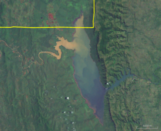
Pongolapoort Dam, commonly referred to as Jozini Dam creating Lake Jozini, is an arch type dam in northern KwaZulu-Natal, South Africa located on the Phongolo River. The dam is situated just north of the settlement of Jozini, 280 km north-east of the port city of Durban. The dam was constructed in 1973 at the eastern end of the narrow gorge separating the Lebombo and Ubombo ranges. The dam mainly serves for irrigation purposes and its hazard potential has been ranked high (3). The Phongolo River is the dam's largest feeder and outlet as well as the dam's only perennial feeder.


