Inishmot

Last updated

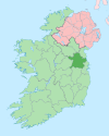
Inishmot is a civil parish in County Meath, Ireland. [1]

County Meath County in the Republic of Ireland

County Meath is a county in Ireland. It is in the province of Leinster and is part of the Mid-East Region. It is named after the historic Kingdom of Meath. Meath County Council is the local authority for the county. At the 2016 census, the population of the county was 195,044. The county town of Meath is Navan. Other towns in the county include Trim, Kells, Laytown, Ashbourne, Dunboyne, and Slane.

Republic of Ireland Country in Europe on the island of Ireland

Ireland, also known as the Republic of Ireland, is a country in north-western Europe occupying 26 of 32 counties of the island of Ireland. The capital and largest city is Dublin, which is located on the eastern side of the island. Around a third of the country's population of 4.9 million people resides in the greater Dublin area. The sovereign state shares its only land border with Northern Ireland, a part of the United Kingdom. It is otherwise surrounded by the Atlantic Ocean, with the Celtic Sea to the south, St George's Channel to the south-east, and the Irish Sea to the east. It is a unitary, parliamentary republic. The legislature, the Oireachtas, consists of a lower house, Dáil Éireann, an upper house, Seanad Éireann, and an elected President who serves as the largely ceremonial head of state, but with some important powers and duties. The head of government is the Taoiseach, who is elected by the Dáil and appointed by the President; the Taoiseach in turn appoints other government ministers.

Related Research Articles

Northern District (Israel) District of Israel

The Northern District is one of Israel's six administrative districts. The Northern District has a land area of 4,478 km², which increases to 4,638 km² when both land and water are included. The district capital is Nof HaGalil and the largest city is Nazareth.

Wright R-2600 Twin Cyclone R-14 piston aircraft engine

The Wright R-2600 Cyclone 14 was an American radial engine developed by Curtiss-Wright and widely used in aircraft in the 1930s and 1940s.

The Mid-America Center is an arena and convention center located in Council Bluffs, Iowa, just five minutes from downtown Omaha, Nebraska. The arena's maximum capacity is about 9,000 for concerts and 6,700 for ice hockey and arena football. The arena continues to provide free parking. Caesars Entertainment began managing the Center in 2012, taking over from SMG.

Castaño del Robledo municipality of Spain

Castaño del Robledo is a town and municipality located in the province of Huelva, Spain. According to the 2005 census, it has a population of 205 inhabitants and covers a 13 km² area. It sits at an altitude of 738m above sea level, and is 113 km from the capital.

Povedilla is a municipality in Albacete, Castile-La Mancha, Spain. It has a population of 672.

German submarine U-388 was a Type VIIC U-boat of Nazi Germany's Kriegsmarine during World War II.

Loup or the Loup is a small village in County Londonderry, Northern Ireland. It lies near the western shore of Lough Neagh between Moneymore, Magherafelt, Ballyronan and Coagh. It is situated within Mid-Ulster District.

Honda Transalp motorcycle

The Honda Transalp is the XL400V, XL600V, XL650V, and XL700V series of dual-sport motorcycles manufactured in Japan by Honda since 1987. The Transalp bikes series feature a liquid-cooled, four-stroke 52° V-twin engine.

Moyvoughly

Moyvoughly is a hamlet in the rolling countryside north of Moate in County Westmeath. It is about 5 km from the town.

Valdelacalzada is a municipality located in the province of Badajoz, Extremadura, Spain. According to the 2005 census (INE), the municipality has a population of 2,700 inhabitants.

Oseja is a municipality located in the province of Zaragoza, Aragon, Spain. According to the 2004 census (INE), the municipality has a population of 52 inhabitants.

Turczyn, Grajewo County Village in Podlaskie Voivodeship, Poland

Turczyn is a village in the administrative district of Gmina Rajgród, within Grajewo County, Podlaskie Voivodeship, in north-eastern Poland. It lies approximately 7 kilometres (4 mi) south-west of Rajgród, 12 km (7 mi) north-east of Grajewo, and 75 km (47 mi) north-west of the regional capital Białystok.

Dean State Forest is a state forest in Lawrence County, Ohio, United States.

The E07A is a three-cylinder gasoline engine developed and manufactured by Honda, with a total displacement of 656 cc. The engine is intended for light-vehicle applications. The E05A and E07A were replaced by the Honda P engine.

German submarine U-600 was a Type VIIC U-boat built for Nazi Germany's Kriegsmarine for service during World War II. She was laid down on 25 January 1941 by Blohm & Voss in Hamburg as yard number 576, launched on 16 October 1941 and commissioned on 11 December 1941 under Kapitänleutnant Bernhard Zurmühlen.

German submarine U-406 was a Type VIIC U-boat built for Nazi Germany's Kriegsmarine for service during World War II. She was laid down on 6 September 1940 by Danziger Werft, Danzig as yard number 107, launched on 16 June 1941 and commissioned on 22 October 1941 under Oberleutnant zur See Horst Dietrichs.

German submarine U-613 was a Type VIIC U-boat built for Nazi Germany's Kriegsmarine for service during World War II. She was laid down on 6 May 1941 by Blohm & Voss, Hamburg as yard number 589, launched on 29 January 1942 and commissioned on 12 March 1942 under Kapitänleutnant Helmut Köppe.

German submarine <i>U-1278</i> German world war II submarine

German submarine U-1278 was a Type VIIC/41 U-boat of Nazi Germany's Kriegsmarine during World War II.

German submarine <i>U-963</i> German world war II submarine

German submarine U-963 was a Type VIIC U-boat of Nazi Germany's Kriegsmarine during World War II.

References

  1. Townlands in Stackallan

Coordinates: 53°42′N6°36′W / 53.700°N 6.600°W / 53.700; -6.600

Geographic coordinate system Coordinate system

A geographic coordinate system is a coordinate system that enables every location on Earth to be specified by a set of numbers, letters or symbols. The coordinates are often chosen such that one of the numbers represents a vertical position and two or three of the numbers represent a horizontal position; alternatively, a geographic position may be expressed in a combined three-dimensional Cartesian vector. A common choice of coordinates is latitude, longitude and elevation. To specify a location on a plane requires a map projection.