
The Western Interior Seaway was a large inland sea that split the continent of North America into two landmasses. The ancient sea, which existed from the early Late Cretaceous to the earliest Paleocene, connected the Gulf of Mexico to the Arctic Ocean. The two land masses it created were Laramidia to the west and Appalachia to the east. At its largest extent, it was 2,500 feet (760 m) deep, 600 miles (970 km) wide and over 2,000 miles (3,200 km) long.

The Smoky Hills are an upland region of hills in the central Great Plains of North America. They are located in the Midwestern United States, encompassing north-central Kansas and a small portion of south-central Nebraska.

Inoceramus is an extinct genus of fossil marine pteriomorphian bivalves that superficially resembled the related winged pearly oysters of the extant genus Pteria. They lived from the Early Jurassic to latest Cretaceous.

The San Juan Basin is a geologic structural basin located near the Four Corners region of the Southwestern United States. The basin covers 7,500 square miles and resides in northwestern New Mexico, southwestern Colorado, and parts of Utah and Arizona. Specifically, the basin occupies space in the San Juan, Rio Arriba, Sandoval, and McKinley counties in New Mexico, and La Plata and Archuleta counties in Colorado. The basin extends roughly 100 miles (160 km) N-S and 90 miles (140 km) E-W.

The Dakota is a sedimentary geologic unit name of formation and group rank in Midwestern North America. The Dakota units are generally composed of sandstones, mudstones, clays, and shales deposited in the Mid-Cretaceous opening of the Western Interior Seaway. The usage of the name Dakota for this particular Albian-Cenomanian strata is exceptionally widespread; from British Columbia and Alberta to Montana and Wisconsin to Colorado and Kansas to Utah and Arizona. It is famous for producing massive colorful rock formations in the Rocky Mountains and the Great Plains of the United States, and for preserving both dinosaur footprints and early deciduous tree leaves.

The Niobrara Formation, also called the Niobrara Chalk, is a geologic formation in North America that was deposited between 87 and 82 million years ago during the Coniacian, Santonian, and Campanian stages of the Late Cretaceous. It is composed of two structural units, the Smoky Hill Chalk Member overlying the Fort Hays Limestone Member. The chalk formed from the accumulation of coccoliths from microorganisms living in what was once the Western Interior Seaway, an inland sea that divided the continent of North America during much of the Cretaceous. It underlies much of the Great Plains of the US and Canada. Evidence of vertebrate life is common throughout the formation and includes specimens of plesiosaurs, mosasaurs, pterosaurs, and several primitive aquatic birds. The type locality for the Niobrara Chalk is the Niobrara River in Knox County in northeastern Nebraska. The formation gives its name to the Niobrara cycle of the Western Interior Seaway.
Colorado is a geologic name applied to certain rocks of Cretaceous age in the North America, particularly in the western Great Plains. This name was originally applied to classify a group of specific marine formations of shale and chalk known for their importance in Eastern Colorado. The surface outcrop of this group produces distinctive landforms bordering the Great Plains and it is a significant feature of the subsurface of the Denver Basin and the Western Canadian Sedimentary Basin. These formations record important sequences of the Western Interior Seaway. As the geology of this seaway was studied, this name came to be used in states beyond Colorado but later was replaced in several of these states with more localized names.

The Tropic Shale is a Mesozoic geologic formation. Dinosaur remains are among the fossils that have been recovered from the formation, including Nothronychus graffami. The Tropic Shale is a stratigraphic unit of the Kaiparowits Plateau of south central Utah. The Tropic Shale was first named in 1931 after the town of Tropic where the Type section is located. The Tropic Shale outcrops in Kane and Garfield counties, with large sections of exposure found in the Grand Staircase–Escalante National Monument.

The Straight Cliffs Formation is a stratigraphic unit in the Kaiparowits Plateau of south central Utah. It is Late Cretaceous in age and contains fluvial, paralic, and marginal marine (shoreline) siliciclastic strata. It is well exposed around the margin of the Kaiparowits Plateau in the Grand Staircase – Escalante National Monument in south central Utah. The formation is named after the Straight Cliffs, a long band of cliffs creating the topographic feature Fiftymile Mountain.

The Carlile Shale is a Turonian age Upper/Late Cretaceous series shale geologic formation in the central-western United States, including in the Great Plains region of Colorado, Kansas, Nebraska, New Mexico, North Dakota, South Dakota, and Wyoming.
The Britton Formation is a geologic formation deposited during the Middle Cenomanian to the Early Turonian ages of the Late Cretaceous in modern-day East Texas. It forms the lower half of the Eagle Ford Group in the northern portion of East Texas. The formation was named by W. L. Moreman in 1932 for outcrops on Mountain Creek near the small town of Britton, south of Dallas. In the Dallas area it has been subdivided into the Six Flags Limestone, Turner Park Member, and Camp Wisdom Member. The Six Flags Limestone is a 3 ft thick fossiliferous calcarenite made up of pieces (prisms) of Inoceramus clams. The Turner Park and Camp Wisdom Members were subdivided based on the numerous volcanic ash beds (bentonites) found in the Turner Park, and the common occurrence of concretions in the Camp Wisdom. They are approximately 120 ft and 250 ft thick in the Dallas area. Thin sandstones known as the Templeton Member are found in Grayson County, north of Dallas, that are age equivalent to the lower part of the Turner Park Member. The Templeton Member was originally described as a part of the Woodbine, but it was recently placed in the Britton Formation of the Eagle Ford Group based on its age as derived by ammonites. Plesiosaur remains are among the vertebrate fossils that have been recovered from its strata.

Megacephalosaurus is an extinct genus of short-necked pliosaur that inhabited the Western Interior Seaway of North America about 94 to 93 million years ago during the Turonian stage of the Late Cretaceous, containing the single species M. eulerti. It is named after its large head, which is the largest of any plesiosaur in the continent and measures up to 1.75 meters (5.7 ft) in length. Megacephalosaurus was one of the largest marine reptiles of its time with an estimated length of 6–9 meters (20–30 ft). Its long snout and consistently sized teeth suggest that it preferred a diet of smaller-sized prey.

The Graneros Shale is a geologic formation in the United States identified in the Great Plains as well as New Mexico that dates to the Cenomanian Age of the Cretaceous Period. It is defined as the finely sandy argillaceous or clayey near-shore/marginal-marine shale that lies above the older, non-marine Dakota sand and mud, but below the younger, chalky open-marine shale of the Greenhorn. This definition was made in Colorado by G. K. Gilbert and has been adopted in other states that use Gilbert's division of the Benton's shales into Carlile, Greenhorn, and Graneros. These states include Kansas, Texas, Oklahoma, Nebraska, and New Mexico as well as corners of Minnesota and Iowa. North Dakota, South Dakota, Wyoming, and Montana have somewhat different usages — in particular, north and west of the Black Hills, the same rock and fossil layer is named Belle Fourche Shale.

The Greenhorn Limestone or Greenhorn Formation is a geologic formation in the Great Plains Region of the United States, dating to the Cenomanian and Turonian ages of the Late Cretaceous period. The formation gives its name to the Greenhorn cycle of the Western Interior Seaway.
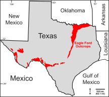
The Eagle Ford Group is a sedimentary rock formation deposited during the Cenomanian and Turonian ages of the Late Cretaceous over much of the modern-day state of Texas. The Eagle Ford is predominantly composed of organic matter-rich fossiliferous marine shales and marls with interbedded thin limestones. It derives its name from outcrops on the banks of the West Fork of the Trinity River near the old community of Eagle Ford, which is now a neighborhood within the city of Dallas. The Eagle Ford outcrop belt trends from the Oklahoma-Texas border southward to San Antonio, westward to the Rio Grande, Big Bend National Park, and the Quitman Mountains of West Texas. It also occurs in the subsurface of East Texas and South Texas, where it is the source rock for oil found in the Woodbine, Austin Chalk, and the Buda Limestone, and is produced unconventionally in South Texas and the "Eaglebine" play of East Texas. The Eagle Ford was one of the most actively drilled targets for unconventional oil and gas in the United States in 2010, but its output had dropped sharply by 2015. By the summer of 2016, Eagle Ford spending had dropped by two-thirds from $30 billion in 2014 to $10 billion, according to an analysis from the research firm Wood Mackenzie. This strike has been the hardest hit of any oil fields in the world. The spending was, however, expected to increase to $11.6 billion in 2017. A full recovery is not expected any time soon.

The Benton Shale is a geologic formation name historically used in Montana, Wyoming, North Dakota, South Dakota, Colorado, Kansas, and Nebraska. In the "mile high" plains in the center of the continent, the named layers preserve marine fossils from the Late Cretaceous Period. The term Benton Limestone has also been used to refer to the chalky portions of the strata, especially the beds of the strata presently classified as Greenhorn Limestone, particularly the Fencepost limestone.
The Belle Fourche Formation or Belle Fourche Shale is a fossiliferous early Late-Cretaceous geologic formation classification in Wyoming. Named for outcrops in Belle Fourche River, Wyoming, this unit name is also used in Montana, North Dakota, and South Dakota.
The Favel Formation is a stratigraphic unit of Late Cretaceous age. It is present in southern Manitoba and southeastern Saskatchewan, and consists primarily of calcareous shale. It was named for the Favel River near Minitonas, Manitoba, by R.T.D. Wickenden in 1945.

Juana Lopez refers to both the uppermost member of the Carlile Shale formation and to the environment that caused it to form. The Juana Lopez Member is calcareous sandstone dated to the Turonian age of the Upper Cretaceous and is exposed in the southern and western Colorado, northern and central New Mexico, and northeastern Utah. The unit has been described as "the most enigmatic" member of the Carlile Shale.

Fencepost limestone, Post Rock limestone, or Stone Post is a stone bed in the Great Plains notable for its historic use as fencing and construction material in north-central Kansas resulting in unique cultural expression. The source of this stone is the topmost layer of the Greenhorn Limestone formation. It is a regional marker bed as well as a valued construction material of the late 19th and early 20th centuries in Kansas. This stone was very suitable for early construction in treeless settlements and it adds a notable rust orange tint to the region's many historic stone buildings. But the most famous use is seen in the countless miles of stone posts lining country roads and highways. This status gives rise to such regional appellations as Stone Post Country, Post Rock Scenic Byway, and The Post Rock Capital of Kansas. This rustic quality finds Fencepost limestone still used in Kansas landscaping today.
