
The York River is a river in Renfrew County, Hastings County and Haliburton County in Ontario, Canada. The river is in the Saint Lawrence River drainage basin, and flows from the southern extension of Algonquin Provincial Park to the Madawaska River.

The Indian River is a river in Renfrew County and Nipissing District in Eastern and Northeastern Ontario, Canada. It is in the Saint Lawrence River drainage basin, and is a left tributary of the Muskrat River.
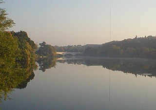
The Otonabee River is a river in Peterborough County in Central Ontario, Canada. The river flows from Katchewanooka Lake, at the north end of the community of Lakefield, through the city of Peterborough to Rice Lake. It is in the Great Lakes Basin and forms part of the Trent-Severn Waterway.

The Scugog River is a river in the city of Kawartha Lakes in Central Ontario, Canada. It is in the Kawartha Lakes region, is part of the Great Lakes Basin, and is a branch of the Trent-Severn Waterway.

The Opeongo River is a river in the Saint Lawrence River drainage basin in Nipissing District in northeastern Ontario, Canada. The river is entirely within Algonquin Provincial Park and Opeongo River Provincial Park, except for a small portion around Victoria Lake, and is a left tributary of the Madawaska River.

The Crowe River is a river in the counties of Haliburton, Hastings, Northumberland and Peterborough in southern Ontario, Canada. It is in the Lake Ontario drainage basin and is a tributary of the Trent River.
Salerno Lake, formerly Devil's Lake, is a lake in the municipalities of Highlands East and Minden Hills in Haliburton County in Central Ontario, Canada. The lake is part of the Kawartha Lakes, and lies in the Great Lakes Basin. It is part of cottage country approximately a 2 1⁄2-hour drive away from Toronto.

The Englehart River is a river in Timiskaming District in northeastern Ontario, Canada. It is in the Saint Lawrence River drainage basin and is a right tributary of the Blanche River.
The Drag River is a river in the municipalities of Minden Hills and Dysart et al in Haliburton County, Southern Ontario, Canada. It is in the Great Lakes Basin and is a right tributary of the Burnt River.

The Crow River is a river in the Saint Lawrence River drainage basin in the Unorganized South Part of Nipissing District in northeastern Ontario, Canada. The river lies entirely within Algonquin Provincial Park and is a right tributary of the Petawawa River.
The Nipissing River is a river in the Saint Lawrence River drainage basin in the Unorganized South Part of Nipissing District in northeastern Ontario, Canada. The river is entirely within Algonquin Provincial Park, and is a left tributary of the Petawawa River.

The Blanche River is a river in the Saint Lawrence River drainage basin in Timiskaming District in northeastern Ontario, Canada. The river is a tributary of Lake Timiskaming and its name is from the French for the colour "white".
The Big East River is a river in Muskoka District and Nipissing District in Northeastern Ontario, Canada. The river is in the Great Lakes Basin, is a left tributary of the Muskoka River, and flows from Algonquin Provincial Park to Huntsville.
Koshlong Creek is a river in geographic Glamorgan Township in the municipality of Highlands East, Haliburton County in Central Ontario, Canada. The river is in the Great Lakes Basin and is a left tributary of the Burnt River.
Black Lake is a lake in the municipality of Dysart et al, Haliburton County in Central Ontario, Canada. It is part of the Great Lakes Basin and lies within geographic Dysart Township.

The Black River is a river in Cochrane District and Timiskaming District in Northeastern Ontario, Canada. It is part of the James Bay drainage basin, and is a right tributary of the Abitibi River. The municipality of Black River-Matheson is named after the river.
The Black River is a river in Simcoe County, the District Municipality of Muskoka, the City of Kawartha Lakes, and Haliburton County in Central Ontario, Canada. It is part of the Great Lakes Basin, and is a right tributary of the Severn River.
The North River is a river in the municipality of Havelock-Belmont-Methuen, Peterborough County in Central Ontario, Canada. It is part of the Great Lakes Basin, and is a right tributary of the Crowe River.

Irvine Creek is a creek in the municipality of Centre Wellington, Wellington County in southwestern Ontario, Canada. It is in the Great Lakes Basin and is a right tributary of the Grand River.
Corben Creek is a stream in the municipality of Minden Hills, Haliburton County, and the unitary city of Kawartha Lakes in Central Ontario, Canada. It is in the Great Lakes Basin and is tributary of Balsam Lake.
