Ivana | |
---|---|
Municipality of Ivana | |
![]() | |
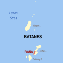
![]() Map of Batanes with Ivana highlighted | |
Coordinates: 20°22′N121°55′E / 20.37°N 121.92°E | |
Country | Philippines |
Region | Cagayan Valley |
Province | Batanes |
District | Lone district |
Barangays | 4 (see Barangays) |
Government | |
• Type | Sangguniang Bayan |
• Mayor | Jerry A. Agana |
• Vice Mayor | Henry Cabuco |
• Representative | Ciriaco B. Gato Jr. |
• Municipal Council | Members |
• Electorate | 1,216 voters (2025) |
Area | |
• Total | 16.54 km2 (6.39 sq mi) |
Elevation | 9.9 m (32.5 ft) |
Highest elevation | 436 m (1,430 ft) |
Lowest elevation | 0 m (0 ft) |
Population (2024 census) [4] | |
• Total | 1,368 |
• Density | 83/km2 (210/sq mi) |
• Households | 413 |
Economy | |
• Income class | 6th municipal income class |
• Poverty incidence | 5.66 |
• Revenue | ₱ 99.02 million (2022) |
• Assets | ₱ 143.2 million (2022) |
• Expenditure | ₱ 59.45 million (2022) |
• Liabilities | ₱ 30.36 million (2022) |
Service provider | |
• Electricity | Batanes Electric Cooperative (BATANELCO) |
Time zone | UTC+8 (PST) |
ZIP code | 3902 |
PSGC | |
IDD : area code | +63 (0)78 |
Native languages | Ivatan Tagalog Ilocano |
Website | www |
Ivana, officially the Municipality of Ivana, [a] is a municipality in the province of Batanes, Philippines. According to the 2024 census, it has a population of 1,368 people, making it the third least populated town in the country. [6]
Ivana is one of the three major pueblos of Batanes in the first half of the 19th century, alongside Basco and Marigatao. [7] A mission was established in the area in the late 18th century, with evangelization being described as successful mainly due to the baptism of seven of the nine principals of Ivana. [8]
In 1789, Joaquin del Castillo became the third governor of Batanes and tried to strengthen his authority in the province. An uprising ensued led by a certain Chivunao, who persuaded his chiefs to rebel against the government. This culminated in a battle in Itbud where the Spaniards' cannons forced the rebels to surrender. [8]
Ivana is located at 20°22′N121°55′E / 20.37°N 121.92°E .
According to the Philippine Statistics Authority, the municipality has a land area of 16.54 square kilometres (6.39 sq mi) [9] constituting 7.55% of the 219.01-square-kilometre- (84.56 sq mi) total area of Batanes.
Ivana is politically subdivided into 4 barangays. [10] Each barangay consists of puroks and some have sitios.
San Vicente was elevated into a barrio in 1955. [11]
PSGC | Barangay | Population | ±% p.a. | |||
---|---|---|---|---|---|---|
2024 [12] | 2010 [13] | |||||
020903001 | Radiwan | 27.9% | 381 | 368 | 0.24% | |
020903002 | Salagao | 26.5% | 363 | 319 | 0.91% | |
020903003 | San Vicente (Igang) | 18.9% | 258 | 230 | 0.81% | |
020903004 | Tuhel (Poblacion) | 26.8% | 366 | 332 | 0.69% | |
Total | 1,368 | 1,249 | 0.64% |
Climate data for Ivana, Batanes | |||||||||||||
---|---|---|---|---|---|---|---|---|---|---|---|---|---|
Month | Jan | Feb | Mar | Apr | May | Jun | Jul | Aug | Sep | Oct | Nov | Dec | Year |
Mean daily maximum °C (°F) | 23 (73) | 23 (73) | 24 (75) | 26 (79) | 28 (82) | 29 (84) | 29 (84) | 29 (84) | 28 (82) | 27 (81) | 26 (79) | 24 (75) | 26 (79) |
Mean daily minimum °C (°F) | 22 (72) | 22 (72) | 23 (73) | 25 (77) | 27 (81) | 28 (82) | 28 (82) | 28 (82) | 27 (81) | 26 (79) | 25 (77) | 23 (73) | 25 (78) |
Average precipitation mm (inches) | 44 (1.7) | 35 (1.4) | 29 (1.1) | 48 (1.9) | 204 (8.0) | 238 (9.4) | 291 (11.5) | 325 (12.8) | 304 (12.0) | 202 (8.0) | 141 (5.6) | 60 (2.4) | 1,921 (75.8) |
Average rainy days | 11.1 | 9.1 | 8.3 | 9.2 | 15.7 | 17.1 | 19.4 | 21.9 | 21.1 | 18.4 | 16.3 | 12.4 | 180 |
Source: Meteoblue [14] |
Year | Pop. | ±% p.a. |
---|---|---|
1903 | 1,856 | — |
1918 | 939 | −4.44% |
1939 | 965 | +0.13% |
1948 | 1,083 | +1.29% |
1960 | 1,039 | −0.34% |
1970 | 989 | −0.49% |
1975 | 942 | −0.97% |
1980 | 972 | +0.63% |
1990 | 1,190 | +2.04% |
1995 | 1,024 | −2.78% |
2000 | 1,293 | +5.13% |
2007 | 1,181 | −1.24% |
2010 | 1,249 | +2.06% |
2015 | 1,327 | +1.16% |
2020 | 1,407 | +1.24% |
2024 | 1,368 | −0.67% |
Source: Philippine Statistics Authority [15] [16] [13] [17] [18] |
In the 2024 census, Ivana had a population of 1,368. [19] The population density was 83 inhabitants per square kilometre (210/sq mi).
Poverty incidence of Ivana
5 10 15 20 25 30 2000 18.40 2003 11.93 2006 21.90 2009 8.94 2012 16.43 2015 18.27 2018 7.00 2021 5.66 Source: Philippine Statistics Authority [20] [21] [22] [23] [24] [25] [26] [27] |
Ivana is part of to the lone congressional district of the province of Batanes. It is governed by a mayor, designated as its local chief executive, and by a municipal council as its legislative body in accordance with the Local Government Code. The mayor, vice mayor, and the councilors are elected directly by the people through an election which is being held every three years.
Position | Name |
---|---|
Congressman | Ciriaco B. Gato Jr. |
Governor | Ronald P. Aguto Jr. |
Vice Governor | Jonathan Enrique V. Nanud Jr. |
Mayor | Jerry A. Agana |
Vice-Mayor | Henry Cabuco |
Councilors | Romeo Emilio Fidel |
Christopher Cabugao | |
Chris Cataluña | |
Norman James Enego | |
Alberto Y. Viegan | |
Frederick Zenon E. Cataluña | |
Cresente Anthony Barsana | |
Boyet Hostallero | |
The Schools Division of Batanes governs the town's public education system. The division office is a field office of the DepEd in Cagayan Valley region. [29] The Ivana-Uyugan Schools District Office governs both public and private elementary and high schools throughout the municipality. This includes the municipality of Uyugan. [30]
{{cite web}}
: Missing or empty |title=
(help)