Mahatao

Last updated
Mahatao
Municipality of Mahatao
Batanes Protected Landscapes and Seascapes Maydangeb Beach.jpg
Maydangeb Beach
Flag of Mahatao, Batanes.png
Mahatao Batanes.png
Ph locator batanes mahatao.png
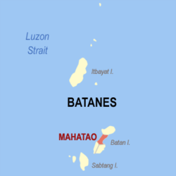
Map of Batanes with Mahatao highlighted
OpenStreetMap
Mahatao
Philippines location map (square).svg
Red pog.svg
Mahatao
Location within the Philippines
Philippines location map (Luzon).svg
Red pog.svg
Mahatao
Mahatao (Luzon)
Philippines Batanes location map.svg
Red pog.svg
Mahatao
Mahatao (Batanes)
Coordinates: 20°25′N121°57′E / 20.42°N 121.95°E / 20.42; 121.95
CountryPhilippines
Region Cagayan Valley
Province Batanes
District Lone district
Barangays 4 (see Barangays)
Government
[1]
  Type Sangguniang Bayan
   Mayor Geronimo Carba
   Vice Mayor Genes Galarion
   Representative Ciriaco B. Gato Jr.
   Municipal Council
Members
  • Noe Avelino Fabro
  • Macario Cabrito Jr.
  • Unching Tabig
  • Ethel Avanceña
  • Joel Fabre
  • Donald Cariaso
  • Bhaybie Fagut
  • Jig Balasbas
   Electorate 1,515 voters (2025)
Area
[2]
  Total
12.90 km2 (4.98 sq mi)
Elevation
[3]
63 m (207 ft)
Highest elevation
1,013 m (3,323 ft)
Lowest elevation
0 m (0 ft)
Population
 (2024 census) [4]
  Total
1,745
  Density140/km2 (350/sq mi)
   Households
497
Economy
   Income class 6th municipal income class
   Poverty incidence
7.84
% (2021) [5]
   Revenue 65.78 million (2022)
   Assets 144.8 million (2022)
   Expenditure 47.8 million (2022)
   Liabilities 48.77 million (2022)
Service provider
  ElectricityBatanes Electric Cooperative (BATANELCO)
Time zone UTC+8 (PST)
ZIP code
3901
PSGC
IDD : area code +63(0)78
Native languages Ivatan
Tagalog
Ilocano

Mahatao, officially the Municipality of Mahatao [a] , is a municipality in the province of Batanes, Philippines. According to the 2024 census, it had a population of 1,745 people. [6]

Contents

History

Aerial view of Mahatao, 1937 Philippine Island - Batan Islands - NARA - 68156364.jpg
Aerial view of Mahatao, 1937

Geography

Diura fishing village Diura Fishing Village.jpg
Diura fishing village

Mahatao is located at 20°25′N121°57′E / 20.42°N 121.95°E / 20.42; 121.95 .

According to the Philippine Statistics Authority, the municipality has a land area of 12.90 square kilometres (4.98 sq mi) [7] constituting

Barangays

Mahatao is politically subdivided into 4 barangays. [8] These barangays are headed by elected officials: Barangay Captain, Barangay Council, whose members are called Barangay Councilors. All are elected every three years.

Hanib was corrected into Hañib by the Philippine Statistics Authority. [9]

PSGC Barangay Population ±% p.a.
2024 [10] 2010 [11]
020904001 Hañib 22.2% 387 372 0.28%
020904002 Kaumbakan 27.9% 486 483 0.04%
020904003 Panatayan 26.5% 462 416 0.74%
020904004 Uvoy ( Poblacion ) 23.5% 410 312 1.94%
Total1,7451,5830.69%

Climate

Climate data for Mahatao, Batanes
MonthJanFebMarAprMayJunJulAugSepOctNovDecYear
Mean daily maximum °C (°F)23
(73)
23
(73)
24
(75)
26
(79)
28
(82)
29
(84)
29
(84)
29
(84)
28
(82)
27
(81)
26
(79)
24
(75)
26
(79)
Mean daily minimum °C (°F)22
(72)
22
(72)
23
(73)
25
(77)
27
(81)
28
(82)
28
(82)
28
(82)
27
(81)
26
(79)
25
(77)
23
(73)
25
(78)
Average precipitation mm (inches)44
(1.7)
35
(1.4)
29
(1.1)
48
(1.9)
204
(8.0)
238
(9.4)
291
(11.5)
325
(12.8)
304
(12.0)
202
(8.0)
141
(5.6)
60
(2.4)
1,921
(75.8)
Average rainy days11.19.18.39.215.717.119.421.921.118.416.312.4180
Source: Meteoblue [12]

Demographics

Population census of Mahatao
YearPop.±% p.a.
1903 1,129    
1918 1,054−0.46%
1939 1,238+0.77%
1948 1,492+2.10%
1960 1,242−1.52%
1970 1,475+1.73%
1975 1,476+0.01%
1980 1,388−1.22%
1990 1,724+2.19%
1995 1,556−1.90%
2000 1,895+4.32%
2007 1,539−2.83%
2010 1,583+1.03%
2015 1,555−0.34%
2020 1,703+1.93%
2024 1,745+0.59%
Source: Philippine Statistics Authority [13] [14] [11] [15] [16]

In the 2024 census, Mahatao had a population of 1,745. [17] The population density was 140 inhabitants per square kilometre (360/sq mi).

Economy

Poverty incidence of Mahatao

5
10
15
20
25
30
2000
19.85
2003
18.40
2006
13.50
2009
8.88
2012
21.44
2015
17.96
2018
17.83
2021
7.84

Source: Philippine Statistics Authority [18] [19] [20] [21] [22] [23] [24] [25]

Government

Local government

Mahatao is part of the lone congressional district of the province of Batanes. It is governed by a mayor, designated as its local chief executive, and by a municipal council as its legislative body in accordance with the Local Government Code. The mayor, vice mayor, and the councilors are elected directly by the people through an election which is being held every three years.

Elected officials

Members of the Municipal Council
(2025–2028) [26]
PositionName
Congressman Ciriaco B. Gato Jr.
MayorGeronimo Carba
Vice-MayorGenes Galarion
CouncilorsNoe Avelino Fabro
Macario Cabrito Jr.
Unching Tabig
Ethel Avanceña
Joel Fabre
Donald Cariaso
Bhaybie Fagut
Jig Balasbas

Education

The Schools Division of Batanes governs the town's public education system and the entire province as a whole. The division office is a field office of the DepEd in Cagayan Valley region. [27] The Mahatao Schools District Office governs the public and private elementary and secondary schools throughout the municipality. [28]

Primary and elementary schools

Secondary school

Notes

  1. Ivatan: Kavahayan nu Mahatao; Ilocano: Ili ti Mahatao; Tagalog: Bayan ng Mahatao

References

  1. Municipality of Mahatao | (DILG)
  2. "2015 Census of Population, Report No. 3 – Population, Land Area, and Population Density" (PDF). Philippine Statistics Authority. Quezon City, Philippines. August 2016. ISSN   0117-1453. Archived (PDF) from the original on May 25, 2021. Retrieved July 16, 2021.
  3. https://en-ca.topographic-map.com/maps/7ub4/Mahatao/.{{cite web}}: Missing or empty |title= (help)
  4. "2024 Census of Population (POPCEN) Population Counts Declared Official by the President". Philippine Statistics Authority. 17 July 2025. Retrieved 18 July 2025.
  5. "PSA Releases the 2021 City and Municipal Level Poverty Estimates". Philippine Statistics Authority. 2 April 2024. Retrieved 28 April 2024.
  6. "2024 Census of Population (POPCEN) Population Counts Declared Official by the President". Philippine Statistics Authority. 17 July 2025. Retrieved 18 July 2025.
  7. "Province:". PSGC Interactive. Quezon City, Philippines: Philippine Statistics Authority . Retrieved 12 November 2016.
  8. "Municipal: Mahatao". PSGC Interactive. Quezon City, Philippines: Philippine Statistics Authority . Retrieved 8 January 2016.
  9. "I. Renaming and Corrections of Names". Philippine Statistics Authority. 21 September 2016. Archived from the original on 26 October 2016. Retrieved 26 October 2016.
  10. Census of Population (2020). "Region II (Cagayan Valley)". Total Population by Province, City, Municipality and Barangay. Philippine Statistics Authority . Retrieved 8 July 2021.
  11. 1 2 Census of Population and Housing (2010). "Region II (Cagayan Valley)" (PDF). Total Population by Province, City, Municipality and Barangay. National Statistics Office . Retrieved 29 June 2016.
  12. "Mahatao, Batanes : Average Temperatures and Rainfall". Meteoblue. Retrieved 5 January 2019.
  13. "2024 Census of Population (POPCEN) Population Counts Declared Official by the President". Philippine Statistics Authority. 17 July 2025. Retrieved 18 July 2025.
  14. Census of Population (2015). "Region II (Cagayan Valley)". Total Population by Province, City, Municipality and Barangay. Philippine Statistics Authority . Retrieved 20 June 2016.
  15. Censuses of Population (1903–2007). "Region II (Cagayan Valley)". Table 1. Population Enumerated in Various Censuses by Province/Highly Urbanized City: 1903 to 2007. National Statistics Office.
  16. "Province of". Municipality Population Data. Local Water Utilities Administration Research Division. Retrieved 17 December 2016.
  17. "2024 Census of Population (POPCEN) Population Counts Declared Official by the President". Philippine Statistics Authority. 17 July 2025. Retrieved 18 July 2025.
  18. "Poverty incidence (PI):". Philippine Statistics Authority. Retrieved December 28, 2020.
  19. "Estimation of Local Poverty in the Philippines" (PDF). Philippine Statistics Authority. 29 November 2005.
  20. "2003 City and Municipal Level Poverty Estimates" (PDF). Philippine Statistics Authority. 23 March 2009.
  21. "City and Municipal Level Poverty Estimates; 2006 and 2009" (PDF). Philippine Statistics Authority. 3 August 2012.
  22. "2012 Municipal and City Level Poverty Estimates" (PDF). Philippine Statistics Authority. 31 May 2016.
  23. "Municipal and City Level Small Area Poverty Estimates; 2009, 2012 and 2015". Philippine Statistics Authority. 10 July 2019.
  24. "PSA Releases the 2018 Municipal and City Level Poverty Estimates". Philippine Statistics Authority. 15 December 2021. Retrieved 22 January 2022.
  25. "PSA Releases the 2021 City and Municipal Level Poverty Estimates". Philippine Statistics Authority. 2 April 2024. Retrieved 28 April 2024.
  26. "MAHATAO - BATANES | Election Results 2025: Vote Count Updates & Tallies | Eleksyon 2025 | GMA News Online". GMA News Online . Retrieved 18 July 2025.
  27. "DEPED REGIONAL OFFICE NO. 02". DepED RO2 | The official website of DepED Regional Office No. 02. Archived from the original on 2022-04-12. Retrieved 2022-03-12.
  28. "Masterlist of Schools" (PDF). Department of Education. January 15, 2021. Retrieved April 12, 2025.