Jacinto, Mississippi | |
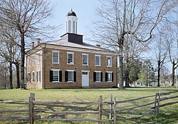
---|---|
Coordinates: 34°45′35″N88°25′42″W / 34.75972°N 88.42833°W Coordinates: 34°45′35″N88°25′42″W / 34.75972°N 88.42833°W | |
Country | United States |
State | Mississippi |
County | Alcorn |
Area | |
• Total | 0.87 sq mi (2.26 km2) |
• Land | 0.87 sq mi (2.26 km2) |
• Water | 0.00 sq mi (0.00 km2) |
Elevation | 561 ft (171 m) |
Population (2020) | |
• Total | 52 |
• Density | 59.56/sq mi (22.99/km2) |
Time zone | UTC-6 (Central (CST)) |
• Summer (DST) | UTC-5 (CDT) |
FIPS code | 28-35340 |
GNIS feature ID | 671757 [2] |
Jacinto, founded in 1836, was named for the Battle of San Jacinto in the Texas Revolution. [3] [4] [5] Jacinto was located in the geographic center of the original Tishomingo County, Mississippi. [6] Within ten years of its founding, Jacinto became a flourishing town with stores, hotels, schools, churches, and taverns, serving as the center of government and commerce for the county. [3]
Jacinto is the site of a courthouse built in 1854 in the Federal style as the county courthouse for the original Tishomingo County. [4] [6] The courthouse has been refurbished and is listed in the National Register of Historic Places. [3] It is open to visitors.
A skirmish occurred on September 7, 1863 in the vicinity of Jacinto between Confederate and Union Cavalry during the American Civil War. [7]
In 1869, Tishomingo was divided into three counties: Tishomingo, Alcorn, and Prentiss. [3] Corinth became the county seat of newly established Alcorn County, Iuka of the reduced Tishomingo County, and Booneville of the new county of Prentiss. [3] When the county seat was moved from Jacinto in 1870, the town's importance declined, and town residents and businesses began moving away. [6]
A post office operated under the name Jacinto from 1840 to 1909. [8]
Jacinto appears on the Glens U.S. Geological Survey Map. [9] [10]
It was first named as a CDP in the 2020 Census which listed a population of 52. [11]
Historical population | |||
---|---|---|---|
Census | Pop. | %± | |
2020 | 52 | — | |
U.S. Decennial Census [12] 2020 [13] |
Race / Ethnicity | Pop 2020 [13] | % 2020 |
---|---|---|
White alone (NH) | 49 | 94.23% |
Black or African American alone (NH) | 0 | 0.00% |
Native American or Alaska Native alone (NH) | 1 | 1.92% |
Asian alone (NH) | 0 | 0.00% |
Pacific Islander alone (NH) | 0 | 0.00% |
Some Other Race alone (NH) | 0 | 0.00% |
Mixed Race/Multi-Racial (NH) | 1 | 1.92% |
Hispanic or Latino (any race) | 1 | 1.92% |
Total | 52 | 100.00% |
Note: the US Census treats Hispanic/Latino as an ethnic category. This table excludes Latinos from the racial categories and assigns them to a separate category. Hispanics/Latinos can be of any race.
Tishomingo County is a county located in the northeastern corner of the U.S. state of Mississippi. As of the 2010 census, the population was 19,593. Its county seat is Iuka.
Prentiss County is a county located in the U.S. state of Mississippi. As of the 2010 census, the population was 25,275. Its county seat is Booneville. The county is named for Seargent Smith Prentiss, a noted speaker and US Congressman from Natchez.
Alcorn County is a county located in the northeastern portion of the U.S. state of Mississippi. As of the 2010 census, the population was 37,057. Its county seat is Corinth. The county is named in honor of Governor James L. Alcorn.
Corinth is a city in and the county seat of Alcorn County, Mississippi, United States. The population was 14,573 at the 2010 census. Its ZIP codes are 38834 and 38835. It lies on the state line with Tennessee.
Baldwyn is a city located in Lee and Prentiss counties, Mississippi, located in the northern part of the Tupelo micropolitan area. The population was 3,297 at the 2010 census.
Winterville is a census-designated place and unincorporated community located in Washington County, Mississippi, near Mississippi Highway 1. Winterville is approximately 3 miles (4.8 km) north of Greenville, the county seat, and approximately 4 miles (6.4 km) south of Lamont.
Eudora is a census-designated place and unincorporated community located in southwestern DeSoto County, Mississippi, United States, approximately 25 miles (40 km) south of Memphis, Tennessee. The intersection of Mississippi Highway 301 and old Mississippi Highway 304 has been the traditional heart of Eudora for decades.
Nitta Yuma is a census-designated place and unincorporated community located in Sharkey County, Mississippi, United States. Nitta Yuma is located along U.S. Route 61, approximately four miles north of Anguilla.
Skene is a census-designated place and unincorporated community located in Bolivar County, Mississippi, United States on Mississippi Highway 446. Skene is approximately 3 miles (4.8 km) west of Boyle and approximately 7 miles (11 km) north of Shaw. Skene was a station on the Boyle and Sunflower branch of the former Yazoo and Mississippi Valley Railroad.
Dundee is a census-designated place and unincorporated community in Tunica County, Mississippi, United States. Dundee is 12 miles (19 km) south-southwest of Tunica. Dundee has a post office with ZIP code 38626.
Dennis is a census-designated place and unincorporated community located at the intersection of Mississippi Highway 25 and Mississippi Highway 4 in Tishomingo County, Mississippi, United States. Dennis is approximately 6 miles (9.7 km) south of Tishomingo and 3 miles (4.8 km) north of Belmont.
Longview is a census-designated place and unincorporated community located in Oktibbeha County, Mississippi. Longview is approximately 7 miles (11 km) southwest of Starkville and approximately 8 miles (13 km) northeast of Sturgis.
Lester E. "Bubba" Carpenter is a Republican member of the Mississippi House of Representatives, representing the First District of Mississippi since 2008.
Paris is a census-designated place and unincorporated community in Lafayette County, Mississippi, United States. Paris is located at the junction of Mississippi Highway 9W and Mississippi Highway 315 10 miles (16 km) east of Water Valley.
Wheeler is a census-designated place and unincorporated community in Prentiss County, Mississippi, United States. Its ZIP code is 38880.
New Site is a census-designated place and unincorporated community in Prentiss County, Mississippi, United States. Its population was 851 at the 2010 U.S. Census. Its ZIP code is 38859.
Mississippi Valley State University is a census-designated place in Leflore County, Mississippi, United States. The population at the 2020 census was 805. It is the location of Mississippi Valley State University and is adjacent to Itta Bena.
Bolivar is a census-designated place and unincorporated community in Bolivar County, Mississippi, United States.
Biggersville is a census-designated place and unincorporated community in Alcorn County, Mississippi, United States. It lies along U.S. Route 45 six miles south of Corinth in the northeastern part of the state. Biggersville is home to Biggersville High School and several small businesses. It was first named as a CDP in the 2020 Census which listed a population of 205.
Mississippi Highway 367 is a short state highway located in northeastern Mississippi. The route starts at MS 356 near Jacinto and travels northeastward. MS 367 intersects several county roads before ending at the Alcorn–Tishomingo county line. The route was designated around 1965, from a former routing of MS 356. The highway was paved by 1974, and the section in Tishomingo County was decommissioned by 1998.