
Mangla is a town situated in District Mirpur within the region of Azad Kashmir. The village is located in the west of the foothills of Mangla's fort. It is surrounded on three sides by the semicurvature of river Jhelum flowing North to South. It is bordered with Jhelum district and with the right bank of Mangla between the State of Azad Kashmir and Punjab province of Pakistan.

Rawalakot is the capital of Poonch district in Azad Kashmir, Pakistan. It is located in the Pir Panjal Range.
Pallandri, also spelled Palandri, originally Pulandari, is a Tehsil which serves as the administrative capital of Sudhanoti district of Azad Kashmir. It is located at latitude 33° 42′ 54″ N, longitude 73° 41′ 9″ E, 90 km (56 mi) from Islamabad, the capital of Pakistan. It is connected with Rawalpindi and Islamabad through Azad Pattan road. The main tribe of Pallandri is the Sudhan tribe. Here in Palindri the first Government of Sidhnuti Azad Kashmir on October 4,1947 was established
Panjera is a historic town in Kotli District in Azad Kashmir. The town lies in the foothills of Himalayas with subtropical microclimate. The area has two flowing streams originating from Sudhanoti district of Azad Kashmir. The town is a typical example of compact market. The economy is predominantly agriculture based with wheat and maize as major crops. Black mulberry is also common with other horticultural crops. Religious festivals are popular and horse riding, tent pegging, horse race and dance are the popular in festivals. Kabaddi is a popular sport, alongside cricket and volleyball.
Bindian is a small village in Kotli District of Pakistani Kashmir.
The Quaid-e-Azam Stadium is a cricket stadium in sector F/2 Mirpur, Azad Kashmir, Pakistan. It is the home of Azad Jammu and Kashmir cricket team. The stadium has a seating capacity of 16,000, making it the largest stadium in Azad Kashmir.
Thub is a village in Dadyal Tehsil of Mirpur District, Azad Kashmir, Pakistan. The village lies on the banks of Poonch River.
Hajira is a small town in Poonch District of Azad Kashmir, Pakistan. It is the headquarters of Tehsil Hajira also known as 'Cheara' in local accents. Hajira is a transport hub, being the center point of different districts. Hajira Ponch is correctly interpreted as ‘Hajira Reach’. In front (South) of Hajira there is district Sudhnoti. On the left side of Hajira there is district Kotli. On the back side (North) of Hajira there is district 'Haveli. District Bagh is in the right side (West) of Hajira. Khai Gala and Rawalakot are the other nearest cities of Hajira and located in the right side (West) of Hajira. While summers can be very hot the winters are mild in Hajira, with snowfall very rare due to the low altitude. The language spoken in Hajira is Urdu similar to the right west side of Hajira as Rawlakot, as you go north to Tata pani towards Kotli and Mirpur the language emerges in to “Pahari” and “Potwari”. Hajira is close to Indian borders hence the main language becoming Urdu. The Indian borders and line of control LOC is near Hajira.
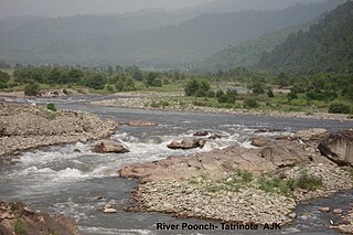
The Poonch River is a tributary of the Jhelum River that flows through Jammu and Kashmir in India, and Jammu and Kashmir in Pakistan.

Abbaspur, commonly known as Bandi or Bandi Abbaspur is a Tehsil located near the line of control which divides Pakistan administered Kashmir and Indian administered Kashmir. It used to be called Gaopalpur before its name was changed. The tehsil is made up of different areas, everything north of Bandi Abbaspur. The mountain facing toward the city in front of it and up to Mehmood Gali is called Tangyran. The mountain side facing toward the Poonch River or Rangard between Abbaspur and Potha is called Choyi. It is the sub-divisional headquarters of Poonch district, Rawalakot, Poonch, Azad Kashmir.

The Mirpur Division is a first-order administrative division of the Pakistani dependent territory of Azad Kashmir. Mirpur is the largest division by population in Azad Kashmir. It comprises the portion of the former Mirpur District of the princely state of Jammu and Kashmir that came under Pakistani control at the end of the Indo-Pakistani War of 1947.
Charhoi is a tehsil of Kotli District, Azad Kashmir, Pakistan. It is the largest city in Kotli district and is the headquarters of the district subdivision. A shrine of the poet Mian Muhammad Bakhsh is about 5 km (3.1 mi) away from the main bazaar. Charhoi has a police station, post office, 3 big mosques and a 50 beds tehsil headquarter hospital, Charhoi Gala is main entrance of Charhoi city. Batowa, new batowa, Narakot, Chahwala, Dahmal Bazar, Damas and meda town is creation of a man name Juna Khanka Kotera, Sanyah are the main places around Charhoi. Charhoi is situated some 50 kilometers away from Mirpur City and around 30 kilometers from Khuiratta. Dahmal Nursery is a lush green place some 5 kilometers away, towards Khuiratta.

Khaigala is a town in Rawalakot tehsil Poonch district of Azad Kashmir. It is located in Rawalakot tehsil of the Poonch district. Majority of population are well educated

Barmang is a town in Rawalakot tehsil of Poonch District, Azad Kashmir, Pakistan and it split in two parts, Barmang Khurd and Barmang Kalan, it has an elevation of 1,736 metres. Barmang is situated nearby to Army Area and between Chak Bazar and Khai Gala Bazar.

Shaheed Gala is a town in Rawalakot tehsil of Poonch District, Azad Kashmir, Pakistan and has an elevation of 2,154 metres. Shaheed is situated nearby to Army Area and the town Toli Pir.
Dhamni is a locality in Rawalakot tehsil, Poonch District, Azad Kashmir and has an elevation of 1,660 metres. Dhamni is situated nearby to the locality Chahar, as well as near Chak.
Chak is a town in Rawalakot tehsil of Poonch District, Azad Kashmir, Pakistan and has an elevation of 1,636 metres. Chak is situated nearby to the locality Barmang, as well as near Army Area.
Chhota Gala is a town in Rawalakot tehsil of Poonch District, Azad Kashmir, Pakistan and has an elevation of 1,929 metres. Chota Gala is situated nearby to the town Khai Gala, as well as near the village Dothan.
Ali Sojal is a town in Rawalakot tehsil of Poonch District, Azad Kashmir, Pakistan and has an elevation of 1,327 metres. Ali Sojal is situated nearby to the Khai Gala, as well as near the village Ban Behak.
Hussainkot is a town in Rawalakot tehsil of Poonch District, Azad Kashmir, Pakistan and has an elevation of 1,726 metres. is situated nearby to Miran Gala.
