It is approximately 28 kilometres (17mi) east of the capital city of Cagayan de Oro. It borders on the municipalities of Villanueva, Claveria and Balingasag, while Macajalar Bay is to the west. Although its land is mostly rocky, it is able to maintain and support its lush vegetation and its main rivers, Cabulig, Dumagooc and Mandangisiao.
Barangays
Jasaan is politically subdivided into 15 barangays, of which 8 are coastal barangays (Aplaya, Solana, Luz Banzon, Kimaya, Lower Jasaan, Bobuntugan, Jampason and San Antonio) and 7 inland barangays (Upper Jasaan, Corrales, San Isidro, Natubo, Danao, San Nicolas, and Ignacio S. Cruz).
In 1830, the mission of Jasaan was established separately from Cagayan de Oro, where its authority and evangelization reached as far as the towns of Sumilao, Linabo and Malitbog in the province of Bukidnon.
The center of civilization of the new parish and its first Church was at "Daanglungsod," which is now the Aplaya, Jasaan, where an old kota (watchtower) still exists. This kota, however, has been moved a few meters from where it originally stood to allow for the construction of the national highway in the 1970s.
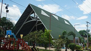
Father Gregorio Parache, S.J. (432 local historical sources of Northern Mindanao by Father Francisco Demetrio, S.J.), was the parish priest of Jasaan at that time. The Jesuits later built the Nuestra Senora de Immaculada Concepcion Church in what is now the Immaculate Conception Church of Jasaan. The original facade of the church has been modified after a series of renovations. The original altar of the church has been moved backward to allow a larger area for the faithful inside the church building. The original sacristy has been moved to the side. The church is registered as a National Cultural Treasure by the National Commission for Culture and the Arts (NCCA).
Jasaan is believed to have been already a municipality during the establishment of the Immaculate Conception Parish in 1840. The old church bells (four of them, excluding the one now at the San Agustin Cathedral at Cagayan de Oro) of the Immaculate Conception Church of Jasaan bore these inscriptions around its outer rim: "Para El Pueblo de Jasaan 1860" [more or less], which suggests that the Spanish government had recognized Jasaan as a town.
With the coming of the Americans at the turn of the 20th century, the national government in 1903 downgraded the political status of Jasaan from that of a municipality to a barrio (a Spanish subdivision of a municipio) and made it a part of the Municipality of Balingasag. The Philippine Commission of 1903, Act No. 960, combined some municipalities in 1903 because the civil government had no control of these municipalities. They could not be defended by the Philippine constabulary or the scouts, nor could they be governed by the pro-American inhabitants!"[6] The Jasaanons called for the restoration of their municipio into a municipality. Eventually, on August 18, 1948, by virtue of Executive Order No. 165, issued by President Elpidio Quirino, Jasaan regained its municipal status. On November 10, 1948, Jasaan was inaugurated as a municipality, and a set of appointed municipal officials assumed office (from the website of Jasaan Local Government).
The early 1970s saw the installation of electric power lines and a road widening program. Ubos had some remnant of Hispanic-style houses along its main street, but these were razed by fire in the early 1980s.
In the 2015 census, the population of Jasaan, Misamis Oriental, was 54,478 people,[3] with a density of 710 inhabitants per square kilometre or 1,800 inhabitants per square mile.
Approximately 20 percent of its 45,310 inhabitants live in the urban center.[10] The population is mostly composed of descendants of those who settled there in the mid-1800s. Most of them are related by consanguinity and they speak a dialect uniquely Jasaanon.
Economy
People are dependent on coconut, livestock and cattle. Other agricultural products, such as corn and vegetables, were minimal. Employment was provided primarily by the government through the public school system, a few national government agencies and the local government unit. Trading and merchandising was mostly confined to Ubos (now Lower Jasaan) along a stretch ending at the public market.
With the coming of electricity in the late 1960s, Jasaan slowly developed into an industrial town. Resins Incorporated and Philippine Iron Construction and Marine Works (PICMW) established their plants at Nahalinan, a village which is a part of Lower Jasaan. The Pilipinas Kao, another industrial plant, was established at Luz Banzon in the 1970s. A substation of the National Power Corporation has been established in Aplaya. Vertical infrastructure in the municipality of Jasaan improved when pavement and widening of the national highway that extends the whole of Northern Mindanao was completed in the 1970s.
At the turn of the millennium, Jasaan has gradually metamorphosed into a resort town. Entrepreneurs have capitalized on the abundance of its spring water sources. The town has spring resorts which draw visitors from neighboring areas.
Attractions
A number of water resorts have been built in the town. The Sagpulon Falls in San Isidro is a tourist attraction. The Napapong Spring is also an attraction from Corrales. The local tourism office of Jasaan maintains the area to preserve is natural allure. The marine sanctuary is located at the waters around the white sands of Agutayan Island, five kilometers off the coast of Bobuntugan.
SophieRed Hotel and Onshore Restaurant is the second hotel that is built in the town. It opens last July 2017.
The town calendar of activities was associated with the calendar of the Roman Catholic Church. After the Lenten celebration, Jasaanons used to celebrate a second town fiesta on May 5, to honor St. Augustine. Then there was a lull until the All Souls Day, when Jasaanons from all over came to pay respects for their dead. This was followed by the parochial fiesta on December 8, and the Feast of the Immaculate Conception.
Lubong-lubong
During the 1960s, the Jasaanon had a calendar of activities that included a New Year's celebration with a "lubong-lubong"–a ritual marking the death of an old year and rejoicing in the birth of a new year. "Lubong-lubong" ("lubong" is vernacular for "to bury") was a mock burial, performed in the town plaza. It began with a masked old man in tattered clothes plodding around the hall where townsfolk gathered in merriment to greet the coming year. As the countdown to the New Year continued, the old man in tattered clothes disappeared in the dark. A little tot in diapers appeared in the midst of hall as the church tolled the knell of the dying year. The ringing shifted to the pealing of all the church bells in the twin belfries of the Immaculate Conception Church to mark the New Year. The Jasaanon was then led to the main door of the church, where a funeral bier awaited. A mock person tagged with the year that passed was laid on top of it, and a man dressed in tattered black cloth recited Latin prayer and led people through a funeral march, which ended at the gates of the Catholic cemetery. The bier was left at the gates to end the ritual.
Town center, poblacion
Immaculate Conception Church
The town center or poblacion of Jasaan is a picture of the Spanish Catholic concept of settlement model–"bajo de las campanas"–where people live around the vicinity of the church within earshot of the peal of the bells. There used to be a bell at the belfry of the Nuestra Senora de la Inmaculada Concepcion Church, where the peal could be heard as far as the hills of Natubo.
This town center used to be one big poblacion, subdivided into nine puroks (hamlets): Purok Uno, Purok Dos, Purok Tres, Purok Cuatro, Purok Cinco, Purok Seis, Purok Siete, Purok Ocho, and Purok Nueve. In the 1960s, these villages adopted names, such as like Siga-Siga, Mauswagon and Mabuligon, etc.
In the early 1970s, when martial law was in force, then-President Ferdinand Marcos (by a series of presidential decrees) made the barangay the basic political unit of Philippines. The Centro, as it used to known, was then split into Upper Jasaan and Lower Jasaan. Local residents would refer to these two as Ubos and Ibabaw, a vernacular indication of their geographical location in the slope: Ubos being Lower, and Ibabaw being Upper. Despite the partition of the Poblacion into two barangays, the old village identifications–the Purok–are still generally referred to in the present Jasaan.
Jasaan town plaza is a good example of the separation of church and state property. A road runs through the middle of the plaza, making the demarcation line. The portion fronting the centuries-old church belongs to the Roman Catholic Church, and on portion on the other side of the road is owned by the local government of Jasaan.
Education
The Jasaan Catholic School (later Mary Immaculate Academy, and recently Saint Mary's Academy of Jasaan) which has been in operation from the start of the 20th century until the mid-70s, experienced competition from Jasaan National High School. The former was established by the Jesuits and later turned over to the Religious of the Virgin Mary, while the latter is a government-operated secondary school.
Schools of higher learning, like the Colegio de Santo Nino and Jasaan School of Midwifery and Jasaan Community College (later Don Mariano Marcos Polytechnic College of Jasaan and now Mindanao University of Science and Technology), were also established in Jasaan.
Related Research Articles
Misamis Occidental is a province located in the region of Northern Mindanao in the Philippines. Its capital is the city of Oroquieta. The province borders Zamboanga del Norte and Zamboanga del Sur to the west and is separated from Lanao del Norte by Panguil Bay to the south and Iligan Bay to the east. The province of Misamis was originally inhabited by Subanens who were an easy target by the sea pirates from Lanao.
Misamis Oriental is a province located in the region of Northern Mindanao in the Philippines. Its capital and provincial center is the city of Cagayan de Oro, which is governed independently from the province. There is a move lately to transfer the provincial capital to the municipality of Laguindingan where the airport is now located.
Gingoog, officially the City of Gingoog,, or simply referred to as Gingoog City, is a 2nd class city in the province of Misamis Oriental, Philippines. According to the 2015 census, it has a population of 124,648 people.
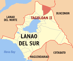
Tagoloan II, officially the Municipality of Tagoloan II, is a 4th class municipality in the province of Lanao del Sur, Philippines. According to the 2015 census, it has a population of 11,169 people.
Jimenez, officially the Municipality of Jimenez, is a 3rd class municipality in the province of Misamis Occidental, Philippines. According to the 2015 census, it has a population of 27,654 people.
Ozamiz, officially the City of Ozamiz or simply referred to as Ozamiz City, is a 3rd class city in the province of Misamis Occidental, Philippines. According to the 2015 census, it has a population of 141,828 people.
Panaon, officially the Municipality of Panaon, is a 5th class municipality in the province of Misamis Occidental, Philippines. According to the 2015 census, it has a population of 10,209 people.
Tangub, officially the City of Tangub or simply referred to as Tangub City, is a 4th class city in the province of Misamis Occidental, Philippines. According to the 2015 census, it has a population of 63,011 people.
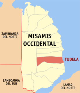
Tudela, officially the Municipality of Tudela,, is a 4th class municipality in the province of Misamis Occidental, Philippines. According to the 2015 census, it has a population of 28,932 people.
Alubijid, officially the Municipality of Alubijid, is a 4th class municipality in the province of Misamis Oriental, Philippines. According to the 2015 census, it has a population of 29,724 people.
Claveria, officially the Municipality of Claveria, is a 1st class municipality in the province of Misamis Oriental, Philippines. According to the 2015 census, it has a population of 48,906 people.
Balingoan, officially the Municipality of Balingoan, is a 5th class municipality in the province of Misamis Oriental, Philippines. According to the 2015 census, it has a population of 11,051 people.
El Salvador, officially the City of El Salvador,, or simply referred to as El Salvador City is a 6th class city in the province of Misamis Oriental, Philippines. According to the 2015 census, it has a population of 50,204 people.
Laguindingan, officially the Municipality of Laguindingan, is a 4th class municipality in the province of Misamis Oriental, Philippines. According to the 2015 census, it has a population of 24,405 people.
Lugait, officially the Municipality of Lugait, is a 2nd class municipality in the province of Misamis Oriental, Philippines. According to the 2015 census, it has a population of 19,758 people.
Magsaysay, officially the Municipality of Magsaysay, is a 4th class municipality in the province of Misamis Oriental, Philippines. According to the 2015 census, it has a population of 34,605 people.
Opol, officially the Municipality of Opol, is a 2nd class municipality in the province of Misamis Oriental, Philippines. According to the 2015 census, it has a population of 61,503 people.
Villanueva, officially the Municipality of Villanueva, is a 2nd class municipality in the province of Misamis Oriental, Philippines. According to the 2015 census, it has a population of 39,378 people.
Cagayan de Oro, officially the City of Cagayan de Oro or simply referred to as CDO, is a 1st class highly urbanized city in Northern Mindanao, Philippines. It is the capital of the province of Misamis Oriental where it is geographically situated but governed administratively independent from it. According to the 2015 census, it has a population of 675,950 people.
The Immaculate Conception Church is a Baroque church located in Poblacion, Upper Jasaan in Misamis Oriental, Philippines. It was declared by the National Museum as a National Cultural Treasure in Northern Mindanao due to its artistic design and cultural values.
References
↑ "Municipality". Quezon City, Philippines: Department of the Interior and Local Government. Retrieved 31 May 2013.
↑ Census of Population and Housing (2010). "Region X (Northern Mindanao)". Total Population by Province, City, Municipality and Barangay. NSO. Retrieved 29 June 2016.
This page is based on this Wikipedia article Text is available under the CC BY-SA 4.0 license; additional terms may apply. Images, videos and audio are available under their respective licenses.


