Jere, Nigeria | |
|---|---|
| Country | |
| State | Borno State |
| Time zone | UTC+1 (WAT) |
Jere is a local government area of Borno State, Nigeria. It has its headquarters in the town of Khaddamari.
Jere, Nigeria | |
|---|---|
| Country | |
| State | Borno State |
| Time zone | UTC+1 (WAT) |
Jere is a local government area of Borno State, Nigeria. It has its headquarters in the town of Khaddamari.
It has an area of 868 km2.
Jere had a population of 211,204 at the 2006 census. Most of the people in Jere are from the Arabic tribes Baggara.
The postal code of the area is 600. [1]
It is one of the sixteen LGAs that constitute the Borno Emirate, a traditional state located in Borno State, Nigeria. [2]

Borno State is a state in the North-East geopolitical zone of Nigeria, bordered by Yobe to the west, Gombe to the southwest, and Adamawa to the south while its eastern border forms part of the national border with Cameroon, its northern border forms part of the national border with Niger, and its northeastern border forms all of the national border with Chad, being the only Nigerian state to border three foreign countries. It takes its name from the historic emirate of Borno, with the emirate's old capital of Maiduguri serving as the capital city of Borno State. The state was formed in 1976 when the former North-Eastern State was broken up. It originally included the area that is now Yobe State, which became a distinct state in 1991.
The Borno Emirate or Borno Sultanate is a traditional Nigerian state formed at the start of the 20th century. It is headed by descendants of the rulers of the Bornu Empire, founded before 1000. The rulers have the title Shehu of Borno. The traditional Emirate of Borno maintains a ceremonial rule of the Kanuri people, based in Maiduguri, Borno State, Nigeria, but acknowledged by the 4 million Kanuri in neighbouring countries.
Abadam is a Local Government Area of Borno State, Nigeria, on the western coast of Lake Chad. It has its headquarters in the town of Malumfatori.
Marte is a Local Government Area of Borno State, Nigeria, on the western coast of Lake Chad. Its headquarters are in the town of Marte
Bama is a Local Government Area of Borno State, Nigeria. It has its headquarters in the town of Bama.
Fikayel Bayo is a Local Government Area of Borno State, Nigeria. Its headquarters are in the town Fikayel.
Damboa is a Local Government Area of Borno State, Nigeria. Its headquarters are in the town of Damboa. It has an area of 6,219 km² and had a population of 233,200 at the 2006 census.
Gubio, also Gobiyo, is a Local Government Area of Borno State, in northeastern Nigeria. Its headquarters are in the town of Gubio.
Guzamala is a Local Government Area of Borno State, Nigeria. Its headquarters are in the town of Gudumbali. It's located approximately 125 kilometres north of the state capital, Maiduguri.

Gwoza is a local government area of Borno State, Nigeria. Its headquarters are in the town of Gwoza, a border town "about 135 kilometres South-East of Maiduguri." The postal code of the area is 610.
Hawul is a Local Government Area of Borno State, Nigeria. It's located in the southern part of the state.
Kaga is a Local Government Area of Borno State, Nigeria. Its headquarters are in the town of Benisheikh.
Kala/Balge is a Local Government Area of Borno State, Nigeria. It is the easternmost LGA of Nigeria. It has itd headquarters in the town of Rann.
Kwaya Kusar is a Local Government Area of Borno State, Nigeria. Its headquarters are in the town of Kwaya Kusar.
Mafa is a Local Government Area of Borno State, Nigeria. It has its headquarters in the town of Mafa.
Magumeri is a Local Government Area of Borno State, Nigeria. Its headquarters are in the town of Magumeri.
Mobbar is a Local Government Area of Borno State, Nigeria. Its headquarters are in the town of Damasak.
Monguno is one of the LGAs Local Government Area of Borno State in northeastern Nigeria.
Ngala is a local government area of Borno State, Nigeria, adjacent to the border with Cameroon. Its headquarters are in the town of Gamboru Ngala.
Nganzai is a Local Government Area of Borno State in northeastern Nigeria. Its headquarters are in the town of Gajiram.
| Local government areas | 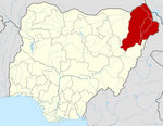 | |
|---|---|---|
| | This Borno State, Nigeria location article is a stub. You can help Wikipedia by expanding it. |