Kaga, Nigeria | |
|---|---|
 Kaga, Nigeria | |
| Coordinates: 11°38′43″N12°27′06″E / 11.6452°N 12.4516°E | |
| Country | |
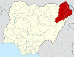
| State | Borno State |
| Time zone | UTC+1 (WAT) |
 | |
Kaga is a Local Government Area of Borno State, Nigeria. Its headquarters are in the town of Benisheikh.
It has an area of 2,700 km2 and a population of 90,015 as of the 2006 census.
The postal code for the area is 601. [1]
Kaga is one of the sixteen LGAs that constitute the Borno Emirate, a traditional state located in Borno State, Nigeria. [2]