
Etowah County is a county located in the northeastern part of the U.S. state of Alabama. As of the 2010 census the population was 104,430. Its county seat is Gadsden. Its name is from a Cherokee word meaning "edible tree". In total area, it is the smallest county in Alabama, but one of the most densely populated. Etowah County comprises the Gadsden Metropolitan Statistical Area.
Colbert County is a county located in the northwestern part of the U.S. state of Alabama. As of the 2010 census the county's population was 54,428. The county seat is Tuscumbia. Its name is in honor of brothers George and Levi Colbert, Chickasaw Indian chiefs.

Jackson County is the northeasternmost county in the U.S. state of Alabama. As of the 2010 census, the population was 53,227. The county seat is Scottsboro. The county was named for Andrew Jackson, general in the United States Army and afterward President of the United States of America. Jackson County is a prohibition or dry county, but three cities within the county are "wet", allowing alcohol sales. Jackson County comprises the Scottsboro, AL Micropolitan Statistical Area. This is included in the Chattanooga-Cleveland-Dalton, TN-GA-AL Combined Statistical Area. It is the site of Russell Cave National Monument, an archeological site with evidence of 8,000 years of human occupation in the Southeast.

Jefferson County is the most populous county in the U.S. state of Alabama, located in the central portion of the state. As of the 2010 census, its population was 658,466. Its county seat is Birmingham, the most populous city in the state. Its rapid growth as an industrial city in the 20th century, based on heavy manufacturing in steel and iron, established its dominance.

Lee County is a county located in east central Alabama. As of the 2010 census the population was 140,247. The county seat is Opelika, and the largest city is Auburn. The county is named for General Robert E. Lee (1807–1870), who served as General in Chief of the Armies of the Confederate States in 1865. Lee County comprises the Auburn-Opelika, AL Metropolitan Statistical Area, which is included in the Columbus-Auburn-Opelika, GA-AL Combined Statistical Area.

Russell County is a county in the southeastern part of the U.S. state of Alabama. As of the 2010 census, the population was 52,947. Its county seat is Phenix City. Its name is in honor of Colonel Gilbert C. Russell, who fought in the wars against the Creek Indians.

Midway is a town located in eastern Bullock County, Alabama, United States. At the 2010 census the population was 499.

Phenix City is a city in Lee and Russell counties in the U.S. state of Alabama, and the county seat of Russell County. As of the 2010 census, the population of the city was 32,822.

Milton is a city in Santa Rosa County, Florida. It is the county seat of Santa Rosa County, and is located in the Pensacola–Ferry Pass–Brent Metropolitan Statistical Area, also known as the Pensacola Metropolitan Area. Milton is located in the geographic center of Santa Rosa County, it is bordered by Pace to the west, and Navarre to the South. As of 2010, the population of Milton was 8,826.
Marvyn, also spelled Marvin, is an unincorporated community located in southern Lee County, Alabama, United States. It sits at the crossroads of Alabama Highway 51 and U.S. Highway 80, and in the Lee County "panhandle" between Russell County and Macon County. It is part of the Columbus, Georgia-Alabama Metropolitan Area.

This is a list of the National Register of Historic Places listings in Russell County, Alabama.

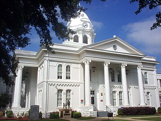
Seale is an unincorporated community in Russell County, Alabama, United States. It was the county seat from 1868 until 1935, and is currently home to Russell County High School and middle school. The former Russell County courthouse, built in 1868, is located in the town.

The following outline is provided as an overview of and topical guide to the U.S. state of Alabama:
Eufaula High School is a secondary school, grades 9 through 12, in Eufaula, Alabama, United States. A member of the Alabama High School Athletic Association (AHSAA), it plays in the 6A division for girls and boys athletics.

Hatchechubbee is an unincorporated community in Russell County, Alabama, United States. Hatchechubbee is located at the junction of Alabama State Route 26 and County Route 65, 6.5 miles (10.5 km) west-southwest of Seale. Hatchechubbee has a post office with ZIP code 36858, which opened on August 17, 1855.

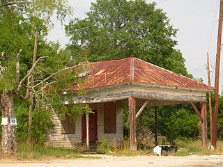
Crawford is an unincorporated community in Russell County, Alabama, United States. Crawford is located at the junction of U.S. Route 80 and Alabama State Route 169, 6.5 miles (10.5 km) west of Ladonia. It was the second county seat of Russell County from 1839-1868 before it removed to Seale.
Mount Hope is an unincorporated community in Lawrence County, Alabama, United States. Its ZIP code is 35651.
Uchee, also known as Spains Stand, is an unincorporated community in Russell County, Alabama, United States.
Wende is an unincorporated community in Russell County, Alabama, United States.


