
The Dagaaba people are an ethnic group located north of the convergence of Ghana, Burkina Faso and Côte d'Ivoire. They speak the Dagaare language, a Gur language made up of the related Northern Dagaare dialects, Southern Dagaare dialects and a number of sub dialects. In northern dialects, both the language and the people are referred to as Dagara. They are related to the Birifor people and the Dagaare Diola. The language is collectively known as Dagaare, and historically some non-natives have taken this as the name of the people. One historian, describing the former usage of "Dagarti" to refer to this community by colonials, writes: "The name 'Dagarti' appears to have been coined by the first Europeans to visit the region, from the vernacular root dagaa. Correctly 'Dagaari' is the name of the language, 'Dagaaba' or 'Dagara' that of the people, and 'Dagaw' or 'Dagawie' that of the land."
Lawra is a small town and is the capital of Lawra district, a district in the Upper West Region of Ghana.

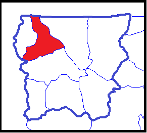
The Upper West Region of Ghana is located in the north-western corner of Ghana and is bordered by Upper East Region to the east, Northern Region to the south, and Burkina Faso to the west and north. The Upper West regional capital and largest settlement is Wa. The Upper West was created by the then Head of State, Jerry Rawlings in 1983 under the Provisional National Defence Council (PNDC) military regime. The area was carved out of the former Upper Region, which is now the Upper East Region. For about thirty-five years, it remained the youngest region of Ghana until 2018 when six more regions were created by the Nana Addo Dankwa Akufo-Addo government; hence increasing the total number of administrative regions in the country to sixteen.

Jirapa/Lambussie District is a former district that was located in Upper West Region, Ghana. Originally created as an ordinary district assembly in 1988. However on 29 February 2008, it was split off into two new districts: Jirapa Municipal District and Lambussie-Karni District. The district assembly was located in the northwest part of Upper West Region and had Jirapa as its capital town.

Ghana is a multilingual country in which about eighty languages are spoken. Of these, English, which was inherited from the colonial era, is the official language and lingua franca. Of the languages indigenous to Ghana, Akan is the most widely spoken in the south. Dagbani, Dagare, Sisaala, Waale, and Gonja are among the most widely spoken in the northern part of the country.
Eremon is a relatively small community located in the Lawra Municipality in the Upper West Region of Ghana. It is about 50 kilometers north of Wa the regional capital. It is the biggest subdistrict in the entire region. The people are mainly Dagaaba and they speak an indigenous language called Dagaare.
Saint Francis of Assisi Girls' Secondary School is the only girls' secondary school located in Jirapa in the Upper West Region of Ghana.
Peter Tenganabang Nanfuri was a former Inspector General of Ghana Police Service who became the Paramount Chief of the Jirapa Traditional Area with the title Naa Ansoleh Ganaa II upon retirement. He served as Inspector General of Police (IGP) in Ghana.
Jirapa is one of the constituencies represented in the Parliament of Ghana. It elects one Member of Parliament (MP) by the first past the post system of election. Jirapa is located in the Jirapa Municipal of the Upper West Region of Ghana.

The Ghana Health Service (GHS) is a Ghanaian government body established in 1996 as part of the Health Sector Reform of Ghana. The Health Service is under the Ministry of Health. The health service primarily administers the health services in Ghana provided by the government and implements government policies on healthcare. The current Director-General of the Health service is Dr. Patrick Kuma-Aboagye who was appointed by President Nana Akufo-Addo on November 25th 2019 to replace Dr. Anthony Nsiah-Asare

Lambussie Karni District is one of the eleven districts in Upper West Region, Ghana. Originally it was formerly part of the then-larger Jirapa/Lambussie District in 1988; until the northern part of the district was later split off to create Lambussie-Karni District on 29 February 2008; thus the remaining part has been renamed as Jirapa District. The district assembly is located in the northwest part of Upper West Region and has Lambussie as its capital town.
The Jirapa Nurses' Training College is public tertiary health institution in the Jirapa in the Upper West Region of Ghana. The activities of the institution is supervised by the Ministry of Education. The University of Ghana awards a Diploma in Nursing after students from the institution have successfully completed a three-year nursing training programme. The institution is accredited by the National Accreditation Board. The Nurses and Midwifery Council (NMC) is the regulates the activities, curriculum and examination of the student nurses and midwives. The council's mandate Is enshrined under section 4(1) of N.R.C.D 117.
Bimbilla is the capital town of Nanumba North District, a district in the Northern Region of Ghana. It is located in the East of the region, and is near the Oti River. The location is situated within the range of 8.5° north to 9.25° north latitude, and between 0.57° east to 0.5° east longitude. It borders five municipalities: Yendi Municipal to the north, Mion Municipal to the northwest, East Gonja Municipal to the west and southwest, Nanumba South Municipal to the south and east, and Zabzugu Municipal to the north-northeast.
Nandom is the capital town of the Nandom Municipal of the Upper West Region of Ghana.
Rubya is the site of a Catholic Church mission to the south of Bukoba near the west bank of Lake Victoria in Muleba District, Kagera Region, Tanzania. A seminary was established at Rubya in 1904, one of the first in German East Africa, as it then was. The seminary still operates. There is a cathedral, a nursing school and a district hospital, all operated by the church.
Clement Kubindiwor Tedam was a Ghanaian politician from the royal family of Paga in the Upper East Region of Ghana.,
Tizza is a small town in the Jirapa District of the Upper West Region of Ghana. The People of this town speak Dagaare
Bagri Festival is an annual festival celebrated by the chiefs and people of Jirapa, Lawra and Nandom in the Upper West region of Ghana. It is usually celebrated in the month of April to January.
The N12 or National Highway 12 is a national highway in Ghana that begins at the Ghana - Côte d'Ivoire border in the Western Region of Ghana and travels generally north to Hamile on the Ghana - Burkina Faso border. Its total length is 670 kilometres.
Jirapa Municipal District is one of the eleven districts in the Upper West Region Ghana. Originally it was formerly part of the then-larger Jirapa/Lambussie District in 1988; until the northern part of the district was later split off to create Lambussie-Karni District on 29 February 2008; that is, the remaining part has been renamed as Jirapa District, which was later elevated to municipal district assembly status on 15 March 2018 to become Jirapa Municipal District. The municipality is located in the northwest parts of the Upper West Region and has Jirapa as its capital town.


