
The Grenville orogeny was a long-lived Mesoproterozoic mountain-building event associated with the assembly of the supercontinent Rodinia. Its record is a prominent orogenic belt which spans a significant portion of the North American continent, from Labrador to Mexico, as well as to Scotland.

The Manzano Mountains are a small mountain range in the central part of the US State of New Mexico. They are oriented north–south and are 30 miles long. The center of the range lies due east of the town of Belen. The name "Manzano" is Spanish for "apple tree"; the mountains were named for apple orchards planted at the nearby town of Manzano.

State Road 485 (NM 485) is a 3.9-mile-long (6.3 km) state highway in the US state of New Mexico. NM 485's southern terminus is near the small town of Jemez Pueblo, at NM 4. The route passes through land belonging to the pueblo near the Nacimiento Mountains and follows the canyon of the Rio Guadalupe until the pavement ends. The highway intersects and adjoins the Jemez Mountain Trail National Scenic Byway.

The Vishnu Basement Rocks is the name recommended for all Early Proterozoic crystalline rocks exposed in the Grand Canyon region. They form the crystalline basement rocks that underlie the Bass Limestone of the Unkar Group of the Grand Canyon Supergroup and the Tapeats Sandstone of the Tonto Group. These basement rocks have also been called either the Vishnu Complex or Vishnu Metamorphic Complex. These Early Proterozoic crystalline rocks consist of metamorphic rocks that are collectively known as the Granite Gorge Metamorphic Suite; sections of the Vishnu Basement Rocks contain Early Paleoproterozoic granite, granitic pegmatite, aplite, and granodiorite that have intruded these metamorphic rocks, and also, intrusive Early Paleoproterozoic ultramafic rocks.
The geology of Wisconsin includes Precambrian crystalline basement rock over three billion years old. A widespread marine environment during the Paleozoic flooded the region, depositing sedimentary rocks which cover most of the center and south of the state.
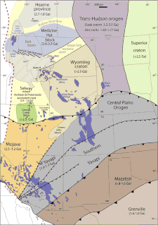
The Mazatzal orogeny was an orogenic event in what is now the Southwestern United States from 1650 to 1600 Mya in the Statherian Period of the Paleoproterozoic. Preserved in the rocks of New Mexico and Arizona, it is interpreted as the collision of the 1700-1600 Mya age Mazatzal island arc terrane with the proto-North American continent. This was the second in a series of orogenies within a long-lived convergent boundary along southern Laurentia that ended with the ca. 1200–1000 Mya Grenville orogeny during the final assembly of the supercontinent Rodinia, which ended an 800-million-year episode of convergent boundary tectonism.
The Yavapai orogeny was an orogenic event in what is now the Southwestern United States from 1710 to 1680 Mya in the Statherian Period of the Paleoproterozoic. Preserved in the rocks of New Mexico and Arizona, it is interpreted as the collision of the 1800-1700 Mya age Yavapai island arc terrane with the proto-North American continent. This was the first in a series of orogenies within a long-lived convergent boundary along southern Laurentia that ended with the ca. 1200–1000 Mya Grenville orogeny during the final assembly of the supercontinent Rodinia, which ended an 800-million-year episode of convergent boundary tectonism.
The Picuris orogeny was an orogenic event in what is now the Southwestern United States from 1.43 to 1.3 billion years ago in the Calymmian Period of the Mesoproterozoic. The event is named for the Picuris Mountains in northern New Mexico and interpreted either as the suturing of the Granite-Rhyolite crustal province to the southern margin of the proto-North American continent Laurentia or as the final suturing of the Mazatzal crustal province onto Laurentia. According to the former hypothesis, this was the second in a series of orogenies within a long-lived convergent boundary along southern Laurentia that ended with the ca. 1200–1000 Mya Grenville orogeny during the final assembly of the supercontinent Rodinia, which ended an 800-million-year episode of convergent boundary tectonism.
The Moppin Complex is a Precambrian geologic complex found in the Tusas Mountains of northern New Mexico. It has not been directly dated, but is thought to be Statherian based on a minimum age of 1.755 Gya from radiometric dating of magmatic intrusions.

The Maquinita Granodiorite is a Precambrian pluton that crops out in the northern Tusas Mountains of New Mexico. It has a radiometric age of 1.755 billion years, corresponding to the Statherian period.

The Vadito Group is a group of geologic formations that crops out in most of the Precambrian-cored uplifts of northern New Mexico. Detrital zircon geochronology and radiometric dating give a consistent age of 1700 Mya for the group, corresponding to the Statherian period.
The Big Rock Formation is a formation that crops out in the Tusas Mountains of northern New Mexico. Detrital zircon geochronology gives a maximum age for the formation of 1665 Mya, corresponding to the Statherian period.
The Tres Piedras Orthogneiss is a pluton in northern New Mexico. It has a U-Pb radiometric age of 1693 Mya, placing it in the Statherian period.
The San Pedro quartz monzonite is a Paleoproterozoic pluton in New Mexico. It has a radiometric age of 1730 Mya, corresponding to the Statherian period.

The San Miguel gneiss is a Paleoproterozoic pluton in the Nacimiento Mountains of New Mexico. It has a radiometric age of 1.695 billion years, corresponding to the Statherian period.
The Uncompahgre Formation is a geologic formation in Colorado. Its radiometric age is between 1707 and 1704 Ma, corresponding to the Statherian period.

The Sevilleta metarhyolite is a geologic formation in central New Mexico. It has a radiometric age of 1665 ± 16 Ma, corresponding to the Statherian period.

The Cibola gneiss is a pluton in central New Mexico. It has a radiometric age of 1653±16 Ma, corresponding to the Statherian period.

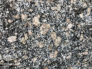
The Sandia granite is a pluton in central New Mexico. It has a radiometric age of 1453±12 Ma, corresponding to the Calymmian period.
The Lilesville Granite, also referred to as the Lilesville pluton, is a ring-shaped body of granitic rock that spans about 94 square miles (240 km2) in Anson, Richmond, and Montgomery Counties in southern North Carolina.


