
Sacramento is the capital city of the U.S. state of California and the seat of Sacramento County. Located at the confluence of the Sacramento River and the American River in Northern California's Sacramento Valley, Sacramento's estimated 2018 population of 501,334 makes it the sixth-largest city in California and the ninth largest capital in the United States. Sacramento is the seat of the California Assembly, the Governor of California, and Supreme Court of California, making it the state's political center and a hub for lobbying and think tanks. Sacramento is also the cultural and economic core of the Sacramento metropolitan area, which had 2010 population of 2,414,783, making it the fifth largest in California.

The University of California, Berkeley is a public research university in Berkeley, California. It was founded in 1868 and serves as the flagship institution of the ten research universities affiliated with the University of California system. Berkeley has since grown to instruct over 40,000 students in approximately 350 undergraduate and graduate degree programs covering numerous disciplines.
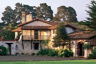
Founded on June 3, 1770, Monterey was the capital of Alta California under both Spain and Mexico until 1850. Monterey hosted California's first theater, public building, public library, publicly funded school, printing press, and newspaper. Monterey was the only port of entry for taxable goods in California. In 1846, the U.S. flag was raised over the Customs House, and California became part of the United States after the Mexican–American War.

Pseudotsuga menziesii is an evergreen conifer species in the pine family, Pinaceae. It is native to western North America and is known as Douglas fir, Douglas-fir, Oregon pine, and Columbian pine. There are two varieties: coast Douglas-fir, and Rocky Mountain Douglas-fir.
A ZIP Code is a postal code used by the United States Postal Service (USPS) in a system it introduced in 1963. The term ZIP is an acronym for Zone Improvement Plan; it was chosen to suggest that the mail travels more efficiently and quickly when senders use the code in the postal address. The basic format consists of five digits. An extended ZIP+4 code was introduced in 1983 which includes the five digits of the ZIP Code, followed by a hyphen and four additional digits that reference a more specific location.
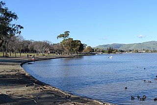
Fremont is a city in Alameda County, California, United States. It was incorporated on January 23, 1956, from the annexing of Centerville, Niles, Irvington, Mission San José, and Warm Springs. The city is named after John C. Frémont, an American explorer and former US Senator from California, Governor from Arizona, Major General in the Union Army, and the first Republican presidential candidate, in 1856.

The California Gold Rush (1848–1855) began on January 24, 1848, when gold was found by James W. Marshall at Sutter's Mill in Coloma, California. The news of gold brought approximately 300,000 people to California from the rest of the United States and abroad. The sudden influx of gold into the money supply reinvigorated the American economy, and the sudden population increase allowed California to go rapidly to statehood, in the Compromise of 1850. The Gold Rush had severe effects on Native Californians and resulted in a precipitous population decline from disease, genocide and starvation. By the time it ended, California had gone from a thinly populated ex-Mexican territory, to having one of its first two U.S. Senators, John C. Frémont, selected to be the first presidential nominee for the new Republican Party, in 1856.

Anaheim is a city in Orange County, California, part of the Los Angeles metropolitan area. As of the 2010 United States Census, the city had a population of 336,265, making it the most populous city in Orange County and the 10th-most populous city in California. Anaheim is the second-largest city in Orange County in terms of land area, and is known for being the home of the Disneyland Resort, the Anaheim Convention Center, and two major sports teams: the Anaheim Ducks ice hockey club and the Los Angeles Angels baseball team.

Colusa County is a county in the U.S. state of California. As of the 2010 census, the population was 21,419. The county seat is Colusa. It is in the Central Valley of California, northwest of the state capital, Sacramento.

Menlo Park is a city at the eastern edge of San Mateo County, in the San Francisco Bay Area of California, in the United States. It is bordered by San Francisco Bay on the north and east; East Palo Alto, Palo Alto, and Stanford to the south; Atherton, North Fair Oaks, and Redwood City to the west. Menlo Park is one of the most educated cities in the state of California and the United States; nearly 70% of residents over the age of 25 has earned a bachelor's degree or higher. Menlo Park had 32,026 inhabitants according to the 2010 United States Census, which had grown to an estimated 34,357 inhabitants by 2017. Menlo Park is the site of Facebook's main campus.

Riverside is a city in Riverside County, California, United States, located in the Inland Empire metropolitan area. Riverside is the county seat of the eponymous county and named for its location beside the Santa Ana River. It is the most populous city in the Inland Empire and in Riverside County, and is located about 55 miles (89 km) east of downtown Los Angeles. It is also part of the Greater Los Angeles area. Riverside is the 59th most populous city in the United States and 12th most populous city in California. As of the 2010 Census, Riverside had a population of 303,871.

The avocado is a tree, long thought to have originated in South Central Mexico, classified as a member of the flowering plant family Lauraceae. The fruit of the plant, also called an avocado, is botanically a large berry containing a single large seed.
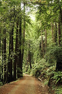
Butano State Park is a state park of California, USA, showcasing a secluded redwood-filled canyon. Located in San Mateo County near Pescadero, the 4,728-acre (1,913 ha) park was established in 1956.

Food 4 Less is a national grocery store grocery chain, currently owned by Kroger. It is a no-frills grocery store where the customers bag their own groceries at the checkout. Kroger operates Food 4 Less stores in California, Illinois, Indiana, and Ohio. In northern and central California, where Kroger does not have the rights to the Food 4 Less name, it operates as Foods Co.

Petersburg is a former settlement in Kern County, California. It was located on Greenhorn Creek 4.5 miles (7.2 km) west-northwest of Miracle Hot Springs, at an elevation of 4731 feet. Petersburg still appeared on maps as of 1956.

Goler Heights, also known simply as Goler, is an unincorporated community in Kern County, California. It is located 6.5 miles (10 km) northwest of Randsburg, at an elevation of 2,579 feet (786 m). The town is named after John Goller, a German immigrant who discovered a placer gold deposit that was later mined and named in his honor.
{{Infobox settlement |name = Jastro Winkle |other_name = Jastro Winkle,California 93308 |native_name = Jastro Diamond |nickname = Jastro Diamond Field |settlement_type =[[Sovereign State] [unincorporated]] |image_skyline = |imagesize = |image_caption = |pushpin_map =California#USA |pushpin_label_position =bottom |pushpin_mapsize = |pushpin_map_caption =Location in California |pushpin_image=California Locator Map with US.PNG |subdivision_type = Country |subdivision_name =United States |subdivision_type1 = State |subdivision_name1 = California |subdivision_type2 =County |subdivision_name2 = Kern County |subdivision_type3 = |subdivision_name3 = | |established_title = |established_date = |coordinates = 35°22′36″N119°04′20″W |elevation_footnotes = |elevation_m =121 |elevation_ft =397 |footnotes =Jastro Winkle, California is the 14 acre site where Mr. H.A. Jastro established a designated Autonomous Electoral District in Kern County California. The Community is situated atop of a Kimberley Pipe and is also known as the Center of the Oil Patch }} Jastro also known as Winkle is an unincorporated community in Kern County, California. It is located on the Atchison, Topeka and Santa Fe Railroad 4 miles (6.4 km) west of Bakersfield, at an elevation of 397 feet.
Warren is a former settlement in Kern County, California.
Bay Terraces is a hilly neighborhood in the southeastern part of San Diego, California, United States. It is bordered by Skyline to the north, Paradise Hills to the southwest, and Alta Vista and South Encanto to the west. The southern end of the neighborhood is bordered by State Route 54 and Bonita. The neighborhood generally includes the ZIP Codes 92114 and 92139.


