Scarface, California

Last updated
Scarface
Unincorporated community
California Locator Map with US.PNG
Red pog.svg
Scarface
Location in California
Usa edcp location map.svg
Red pog.svg
Scarface
Scarface (the US)
Coordinates: 41°24′42″N121°17′42″W / 41.41167°N 121.29500°W / 41.41167; -121.29500 Coordinates: 41°24′42″N121°17′42″W / 41.41167°N 121.29500°W / 41.41167; -121.29500
Country United States
State California
County Modoc County
Elevation [1] 4,390 ft (1,338 m)

Scarface is an unincorporated community in Modoc County, California. [1] It is located on the former Great Northern Railway Bieber Line 9 miles (14 km) northeast of White Horse, [2] at an elevation of 4390 feet (1338 m). [1]

Unincorporated area Region of land not governed by own local government

In law, an unincorporated area is a region of land that is not governed by a local municipal corporation; similarly an unincorporated community is a settlement that is not governed by its own local municipal corporation, but rather is administered as part of larger administrative divisions, such as a township, parish, borough, county, city, canton, state, province or country. Occasionally, municipalities dissolve or disincorporate, which may happen if they become fiscally insolvent, and services become the responsibility of a higher administration. Widespread unincorporated communities and areas are a distinguishing feature of the United States and Canada. In most other countries of the world, there are either no unincorporated areas at all, or these are very rare; typically remote, outlying, sparsely populated or uninhabited areas.

Modoc County, California County in California ----, United States

Modoc County is a county in the far northeast corner of the U.S. state of California. As of the 2010 census, the population was 9,686. making it the third-least populous county in California. The county seat and only incorporated city is Alturas. Previous county seats include Lake City and Centerville; the latter is now a ghost town. The county borders Nevada and Oregon.

California State of the United States of America

California is a state in the Pacific Region of the United States. With 39.6 million residents, California is the most populous U.S. state and the third-largest by area. The state capital is Sacramento. The Greater Los Angeles Area and the San Francisco Bay Area are the nation's second- and fifth-most populous urban regions, with 18.7 million and 8.8 million residents respectively. Los Angeles is California's most populous city, and the country's second-most populous, after New York City. California also has the nation's most populous county, Los Angeles County, and its largest county by area, San Bernardino County. The City and County of San Francisco is both the country's second-most densely populated major city after New York City and the fifth-most densely populated county, behind only four of the five New York City boroughs.

The name honors Scarface Charley, one of the warriors in Captain Jack's forces during the Modoc War. [2]

Scarface Charley Captain Jacks right-hand man and war chief of the Modoc tribe of Native Americans

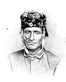
Scarface Charley was a chief of the Modoc tribe of Native Americans. He took part in the Modoc War of 1872–73 in California, and is considered to have fired the first shot at the Battle of Lost River. On April 26, 1873, Scarfaced Charley led a victorious attack against a patrol of 63 soldiers. He killed all five of the officers in the patrol, as well as twenty others. It is widely written that he stopped the slaughter and told the soldiers, "We've killed enough of you, now go home."

Kintpuash chief of the Native American Modoc tribe

Kintpuash, also known as Captain Jack, was a chief of the Modoc tribe of California and Oregon. He led a band from the Klamath Reservation to return to their lands in California, where they resisted return. From 1872 to 1873, their small force made use of the lava beds, holding off more numerous United States Army forces for months in the Modoc War.

The Modoc War, or the Modoc Campaign, was an armed conflict between the Native American Modoc people and the United States Army in northeastern California and southeastern Oregon from 1872 to 1873. Eadweard Muybridge photographed the early part of the US Army's campaign.

Related Research Articles

Alturas, California City in California, United States

Alturas is a city in and the county seat of Modoc County, California. The population was 2,827 at the 2010 census.

Stronghold, California Unincorporated community in California, United States

Stronghold is an unincorporated community in Modoc County, California. It is located on the Southern Pacific Railroad, 3 miles (4.8 km) northwest of Newell, at an elevation of 4035 feet.

Ambrose, Modoc County, California Unincorporated community in California, United States

Ambrose is an unincorporated community in Modoc County, California. It is located on the Southern Pacific Railroad 11 miles (18 km) southwest of Jacks Butte, at an elevation of 4970 feet.

Boles, California Unincorporated community in California, United States

Boles is an unincorporated community in Modoc County, California. It is located on the Southern Pacific Railroad 3.25 miles (5 km) east-southeast of Hackamore, at an elevation of feet ( m). at an elevation of 4879 feet.

Brooks Mill, California Unincorporated community in California, United States

Brooks Mill is an unincorporated community in Modoc County, California. It is located on Soup Creek 19 miles (31 km) southeast of Alturas, at an elevation of feet ( m). at an elevation of 5344 feet.

Cantrall Mill, California Unincorporated community in California, United States

Cantrall Mill is an unincorporated community in Modoc County, California. It is located near the mouth of Cherry Creek 16 miles (26 km) southeast of Alturas, at an elevation of 6033 feet.

Copic, California Unincorporated community in California, United States

Copic is an unincorporated community in Modoc County, California. It is located on the Southern Pacific Railroad 2 miles (3.2 km) southeast of Newell, at an elevation of 4039 feet.

Day, California Unincorporated community in California, United States

Day is an unincorporated community in Modoc County, California. It is located 22 miles (35 km) west of Adin, at an elevation of 3645 feet.

Demuth, California Unincorporated community in California, United States

Demuth is an unincorporated community in Modoc County, California. It is located on the former Great Northern Railway Bieber Line 7.25 miles (12 km) east-northeast of White Horse, at an elevation of 4255 feet.

Fletcher, California Former settlement in California, United States

Fletcher is a former settlement in Modoc County, California. It was located on the Southern Pacific Railroad 11 miles (18 km) west-southwest of Alturas, at an elevation of 4337 feet.

Hollenbeck, California Former settlement in California, United States

Hollenbeck is a former settlement in Modoc County, California. It was located on the former Great Northern Railway Bieber Line 12 miles (19 km) north-northeast of White Horse, at an elevation of 4347 feet.

Homestead, Modoc County, California Unincorporated community in California, United States

Homestead is an unincorporated community in Modoc County, California. It is located on the Southern Pacific Railroad 3 miles (4.8 km) northwest of Newell, at an elevation of 4035 feet.

Liskey, California Unincorporated community in California, United States

Liskey is an unincorporated community in Modoc County, California. It is located on the former Great Northern Railway Bieber Line 3.25 miles (5.2 km) southwest of Newell, at an elevation of 4039 feet.

McArthur, Modoc County, California Unincorporated community in California, United States

McArthur is an unincorporated community in Modoc County, California. It is located on the Southern Pacific Railroad 11 miles (18 km) south of Alturas, at an elevation of 4373 feet.

Paola, California Former settlement in California, United States

Paola is a former settlement in Modoc County, California. It was located on the Southern Pacific Railroad 2.5 miles (4 km) south-southeast of Alturas, at an elevation of 4363 feet.

Perez, California Unincorporated community in California, United States

Perez is an unincorporated community in Modoc County, California. It is located on the Southern Pacific Railroad 4 miles (6.4 km) north-northeast of Timber Mountain, at an elevation of 4180 feet.

Cornell, Modoc County, California Unincorporated community in California, United States

Cornell is an unincorporated community in Modoc County, California. It is located on the Southern Pacific Railroad 6.5 miles (10 km) south-southeast of Newell, at an elevation of 4124 feet.

References

  1. 1 2 3 U.S. Geological Survey Geographic Names Information System: Scarface, California
  2. 1 2 Durham, David L. (1998). California's Geographic Names: A Gazetteer of Historic and Modern Names of the State. Clovis, Calif.: Word Dancer Press. p. 415. ISBN   1-884995-14-4.