
Los Angeles, officially the City of Los Angeles and often known by its initials L.A., is the most populous city in California, the second most populous city in the United States, after New York City, and the third most populous city in North America. With an estimated population of four million, Los Angeles is the cultural, financial, and commercial center of Southern California. The city is known for its Mediterranean climate, ethnic diversity, Hollywood and the entertainment industry, and its sprawling metropolis. Los Angeles is the largest city on the West Coast of North America.

Sacramento is the capital city of the U.S. state of California and the seat of Sacramento County. Located at the confluence of the Sacramento River and the American River in Northern California's Sacramento Valley, Sacramento's estimated 2018 population of 501,334 makes it the sixth-largest city in California and the ninth largest capital in the United States. Sacramento is the seat of the California Assembly, the Governor of California, and Supreme Court of California, making it the state's political center and a hub for lobbying and think tanks. Sacramento is also the cultural and economic core of the Sacramento metropolitan area, which had 2010 population of 2,414,783, making it the fifth largest in California.
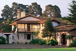
Founded on June 3, 1770, Monterey was the capital of Alta California under both Spain and Mexico until 1850. Monterey hosted California's first theater, public building, public library, publicly funded school, printing press, and newspaper. Monterey was the only port of entry for taxable goods in California. In 1846, the U.S. flag was raised over the Customs House, and California became part of the United States after the Mexican–American War.

The California Gold Rush (1848–1855) began on January 24, 1848, when gold was found by James W. Marshall at Sutter's Mill in Coloma, California. The news of gold brought approximately 300,000 people to California from the rest of the United States and abroad. The sudden influx of gold into the money supply reinvigorated the American economy, and the sudden population increase allowed California to go rapidly to statehood, in the Compromise of 1850. The Gold Rush had severe effects on Native Californians and resulted in a precipitous population decline from disease, genocide and starvation. By the time it ended, California had gone from a thinly populated ex-Mexican territory, to having one of its first two U.S. Senators, John C. Frémont, selected to be the first presidential nominee for the new Republican Party, in 1856.

The Spanish missions in California comprise a series of 21 religious outposts or missions established between 1769 and 1833 in today's U.S. State of California. Founded by Catholic priests of the Franciscan order to evangelize the Native Americans, the missions led to the creation of the New Spain province of Alta California and were part of the expansion of the Spanish Empire into the most northern and western parts of Spanish North America.

Vallejo is a waterfront city in Solano County, California, located in the North Bay subregion of the San Francisco Bay Area. Vallejo is geographically the closest North Bay city to the inner East Bay, so it is sometimes associated with that region. Its population was 115,942 at the 2010 census. It is the tenth most populous city in the San Francisco Bay Area, and the largest in Solano County. Vallejo sits on the northeastern shore of San Pablo Bay, 30 miles north of San Francisco, the northwestern shore of the Carquinez Strait and the southern end of the Napa River, 15 miles south of Napa. The city is named after General Mariano Guadalupe Vallejo, a native Californio, leading proponent of California's statehood, and one of the first members of the California State Senate; the neighboring city of Benicia is named for his wife, Francisca Benicia Carrillo de Vallejo.

The San Andreas Fault is a continental transform fault that extends roughly 1,200 kilometers (750 mi) through California. It forms the tectonic boundary between the Pacific Plate and the North American Plate, and its motion is right-lateral strike-slip (horizontal). The fault divides into three segments, each with different characteristics and a different degree of earthquake risk. The slip rate along the fault ranges from 20 to 35 mm /yr.

Yolo County, officially the County of Yolo, is a county located in the northern portion of the U.S. state of California. As of the 2010 census, the population was 200,849. Its county seat is Woodland.

Anaheim is a city in Orange County, California, part of the Los Angeles metropolitan area. As of the 2010 United States Census, the city had a population of 336,265, making it the most populous city in Orange County and the 10th-most populous city in California. Anaheim is the second-largest city in Orange County in terms of land area, and is known for being the home of the Disneyland Resort, the Anaheim Convention Center, and two major sports teams: the Anaheim Ducks ice hockey club and the Los Angeles Angels baseball team.
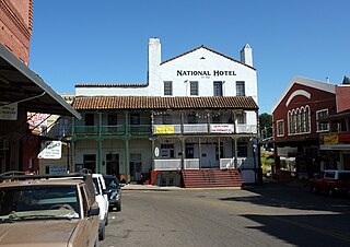
Jackson is the county seat of Amador County, California. The population was 4,651 at the 2010 census, up from 3,989 at the 2000 census. The city is accessible by both State Route 49 and State Route 88.
Colusa is the county seat of Colusa County, California. The population was 5,971 at the 2010 census, up from 5,402 at the 2000 census. Colusi originates from the local Coru Native American tribe, who in the 1840s lived on the opposite side of the Sacramento River.

Coachella is a city in Riverside County, California; it is the easternmost city in the region known as the Coachella Valley. It is 28 miles (45 km) east of Palm Springs, 80 miles (130 km) east of Riverside, and 130 miles (210 km) east of Los Angeles.

Riverside is a city in Riverside County, California, United States, located in the Inland Empire metropolitan area. Riverside is the county seat of the eponymous county and named for its location beside the Santa Ana River. It is the most populous city in the Inland Empire and in Riverside County, and is located about 55 miles (89 km) east of downtown Los Angeles. It is also part of the Greater Los Angeles area. Riverside is the 59th most populous city in the United States and 12th most populous city in California. As of the 2010 Census, Riverside had a population of 303,871.

Santa Barbara is the county seat of Santa Barbara County in the U.S. state of California. Situated on a south-facing section of coastline, the longest such section on the West Coast of the United States, the city lies between the steeply rising Santa Ynez Mountains and the Pacific Ocean. Santa Barbara's climate is often described as Mediterranean, and the city has been promoted as the "American Riviera". As of 2014, the city had an estimated population of 91,196, up from 88,410 in 2010, making it the second most populous city in the county after Santa Maria. The contiguous urban area, which includes the cities of Goleta and Carpinteria, along with the unincorporated regions of Isla Vista, Montecito, Mission Canyon, Hope Ranch, Summerland, and others, has an approximate population of 220,000. The population of the entire county in 2010 was 423,895.

The avocado, a tree with probable origin in South Central Mexico, is classified as a member of the flowering plant family Lauraceae. The fruit of the plant, also called an avocado, is botanically a large berry containing a single large seed.

Mount Whitney is the tallest mountain in California, as well as the highest summit in the contiguous United States and the Sierra Nevada—with an elevation of 14,505 feet (4,421 m). It is in Central California, on the boundary between California's Inyo and Tulare counties, 84.6 miles (136.2 km) west-northwest of the lowest point in North America at Badwater Basin in Death Valley National Park at 282 ft (86 m) below sea level. The west slope of the mountain is in Sequoia National Park and the summit is the southern terminus of the John Muir Trail which runs 211.9 mi (341.0 km) from Happy Isles in Yosemite Valley. The east slope is in the Inyo National Forest in Inyo County.
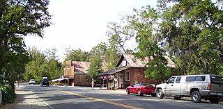
Coloma is a census-designated place in El Dorado County, California, USA. It is approximately 36 miles (58 km) northeast of Sacramento, California. Coloma is most noted for being the site where James W. Marshall found gold in the Sierra Nevada foothills, at Sutter's Mill on January 24, 1848, leading to the California Gold Rush. Coloma's population is 529.


