
John Brewer Cameron (1843 - 1897) was a geodetic surveyor in Australia. He is best known for his survey of the border between Queensland and New South Wales. [1] He also surveyed part of the border between South Australia and Western Australia. [2]
John Brewer Cameron (1843 - 1897) was a geodetic surveyor in Australia. He is best known for his survey of the border between Queensland and New South Wales. [1] He also surveyed part of the border between South Australia and Western Australia. [2]
John Brewer Cameron was born on 31 December 1843 in Kilmonivaig, Inverness, Scotland. [1]

Between 1879 and 1881 the official survey of the 29ºS parallel border between Queensland and New South Wales was conducted by Cameron (employed by the New South Wales Government) and George Chale Watson (employed by the Queensland Government). [3]
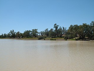
Astronomical observations were taken at the Barringun telegraph station to determine the latitude and longitude. Following these observations, the Zero Obelisk was erected on the banks of the Warrego River, just north of the town of Barringun. [3] [4]

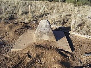
From this mark, the first 5-mile chord was produced westerly and the mile posts offset from this chord to the arc (chord and arc are used when surveying latitude to allow for curvature of the Earth). This continued until the survey intersected longitude 141º (a point now known as Cameron Corner), a distance of 285 miles 24.96 chains. [3] That spot is marked by the Cameron Corner Survey Marker. [5]

Watson withdrew from the survey and Cameron then returned to the Zero Obelisk at Barringun and marked the line to the east in a similar fashion. Cameron then erected a 1 ton survey post on the west bank of the Barwon River to mark the end of the survey. [3] [6]
For approximately the last 10 years of his life he was living in New Guinea. There he worked as a surveyor in New Guinea, mostly in the service of the government[ which? ] but also on private work. He owned a large amount of good land and used part of it as a plantation. [2]
He was the first magistrate in the western part of the territory. He established the Government station at Mabaduan ( 9°16′38″S142°44′14″E / 9.2773°S 142.7373°E ), but then relocated to Daru, leaving the station in charge of Mr Hely. [2]
Cameron came to Brisbane in December 1897 to seek partners to help him develop his land in New Guinea. While there, he died of heart disease on 31 December 1897 at the Grand Hotel where he was staying. [1] As he was unmarried and his family were in Victoria, a private funeral was arranged in Brisbane, and the Premier of Victoria communicated news of his death to his family. [2] He was buried on 31 December 1897 in Toowong Cemetery. [7] [8]
The border point Cameron Corner is named after him and also the locality of Cameron Corner. [9] [10]
The Zero Obilisk, Cameron Corner Survey Marker and Cameron's 1 Ton Survey Post are listed on the Queensland Heritage Register. [4] [5] [6]

Coolangatta is a coastal suburb in the City of Gold Coast, Queensland, Australia. It is the Gold Coast's southernmost suburb and it borders New South Wales. In the 2021 census, Coolangatta had a population of 6,491 people.

Thargomindah is a rural town and locality in the Shire of Bulloo, Queensland, Australia. The town of Thargomindah is the administrative centre for the Shire of Bulloo. In the 2021 census, the locality of Thargomindah had a population of 243 people.

Mungindi is a town and locality on the border of New South Wales (NSW) and Queensland, Australia. The town is within Moree Plains Shire in New South Wales. Within Queensland, the locality is split between the Shire of Balonne and the Goondiwindi Region with the town in the Shire of Balonne. It possesses a New South Wales postcode. Mungindi sits on the Carnarvon Highway and straddles the Barwon River which is the border between New South Wales and Queensland. In the 2021 census, the locality of Mungindi had a population of 487 people in New South Wales and 124 people in Queensland, a total of 611 people.

Cameron Corner is an outback locality in the Shire of Bulloo, Queensland, Australia. It is on the Queensland border with New South Wales to the south and South Australia to the west. In the 2021 census, Cameron Corner had a population of 19 people.

Haddon Corner is a heritage-listed site in Tanbar, Shire of Barcoo, Queensland, Australia. It is in outback Channel Country at South-West Queensland, on the border corner with South Australia. It was added to the Queensland Heritage Register on 9 November 2012.

Noccundra is a rural town and locality in the Shire of Bulloo in South West Queensland, Australia. The town was previously known as Nocundra. Prior to 2020 the locality was previously known as Nockatunga.

The Shire of Bulloo is a local government area in South West Queensland, Australia.

Hungerford is an outback town in the Shire of Bulloo and a locality in the Shire of Bulloo and Shire of Paroo, South West Queensland, Australia. The locality is on the Queensland border with New South Wales.

South West Queensland is a remote region in the Australian state of Queensland which covers 319,808 km2 (123,479 sq mi). The region lies to the south of Central West Queensland and west of the Darling Downs and includes the Maranoa district and parts of the Channel Country. The area is noted for its cattle grazing, cotton farming, opal mining and oil and gas deposits.
Bulloo Downs Station, most commonly referred to as Bulloo Downs, is a pastoral lease that operates as a cattle station in the Shire of Bulloo, Queensland, Australia. It is located on the traditional lands of the Bitjara.
Barringun is a rural locality in the Shire of Paroo, Queensland, Australia. It is on the border of Queensland and New South Wales. In the 2021 census, Barringun had a population of 17 people.
Durham is a rural locality in the Shire of Bulloo, Queensland, Australia. It is on the Queensland border with South Australia. In the 2021 census, Durham had a population of 31 people.

Cameron's 1 Ton Survey Post is a heritage-listed survey marker at the Barwon River, Mungindi, Shire of Balonne, Queensland, Australia. It was established in 1882. It was added to the Queensland Heritage Register on 21 October 1992.
Zero Obelisk is a heritage-listed survey marker on the east bank of the Warrego River, Barringun, Shire of Paroo, Queensland, Australia. It was established in 1879. It was added to the Queensland Heritage Register on 21 October 1992. The Zero Obelisk marks the beginning of the first official survey of the border between the colonies of Queensland and New South Wales in 1879-80.
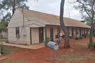
Royal Mail Hotel is a heritage-listed hotel at Archernar Street, Hungerford, Shire of Bulloo, Queensland, Australia. It was built from c. 1897 onwards. It was added to the Queensland Heritage Register on 31 August 2001.

Bulloo Downs is a rural locality in the Shire of Bulloo, Queensland, Australia. It is on the Queensland border with New South Wales. In the 2021 census, Bulloo Downs had "no people or a very low population".

Cameron Corner Survey Marker is a heritage-listed survey marker in the locality of Cameron Corner, Shire of Bulloo, Queensland, Australia. The survey marker is at the border corner of South-West Queensland with New South Wales and South Australia; it was established in 1880. It was added to the Queensland Heritage Register on 9 November 2012.

Poeppel Corner Survey Marker is a heritage-listed survey marker at Poeppel Corner on the border corner of Queensland, South Australia and Northern Territory. In Queensland it is with the locality of Birdsville in the Shire of Diamantina. It was added to the Queensland Heritage Register on 9 November 2012.

Queensland is the north-eastern state of Australia and has land borders with three other Australian states and territories: New South Wales, South Australia and Northern Territory. To the north of Queensland is the Torres Strait separating the Australian mainland from Papua New Guinea. To the east of Queensland is the Coral Sea, part of the Pacific Ocean. There are many islands off the Queensland coast which form part of the state of Queensland.
Cameron County, Queensland is a County of Queensland in Australia, in the South Gregory District Land District.
This article was based on material from Surveying the Queensland New South Wales border published by The State of Queensland 2018 under CC-BY-4.0 licence, accessed on 7 October 2018.
![]() Media related to John Brewer Cameron at Wikimedia Commons
Media related to John Brewer Cameron at Wikimedia Commons