
Hanko is a town in Finland, located in the southern coast of the country. Hanko is situated in the western part of the Uusimaa region. The population of Hanko is approximately 8,000, while the sub-region has a population of approximately 40,000. It is the 121st most populous municipality in Finland.

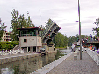
Lappeenranta is a city in Finland and the regional capital of South Karelia. It is located in the southeastern interior of the country and in the Finnish Lakeland. The population of Lappeenranta is approximately 73,000, while the sub-region has a population of approximately 89,000. It is the 13th most populous municipality in Finland, and the 11th most populous urban area in the country.

Kirkkonummi is a municipality in Finland, located in the southern coast of the country. Kirkkonummi is situated in the western part of the Uusimaa region. The population of Kirkkonummi is approximately 42,000. It is the 28th most populous municipality in Finland. Kirkkonummi is part of the Helsinki Metropolitan Area, which has approximately 1.6 million inhabitants.

Joensuu is a city in Finland and the regional capital of North Karelia. It is located in the eastern interior of the country and in the Finnish Lakeland. The population of Joensuu is approximately 79,000, while the sub-region has a population of approximately 128,000. It is the 11th most populous municipality in Finland, and the ninth most populous urban area in the country.
Asikkala is a municipality of Finland. Its seat is in Vääksy, at the shores of the Lake Päijänne. It is located in the province of Southern Finland and is part of the Päijänne Tavastia region. Asikkala's neighboring municipalities are Hämeenlinna, Heinola, Hollola, Lahti, Padasjoki and Sysmä.

Forssa is a town and municipality of Finland. It is located almost in the centre of a triangle defined by the three largest major cities in Finland, in the Tavastia Proper region, and which is crossed by Highway 2 between Pori and Helsinki and Highway 10 between Turku and Hämeenlinna. The town has a population of 16,475 and covers an area of 253.38 square kilometres (97.83 sq mi) of which 4.61 km2 (1.78 sq mi) is water. The population density is 66.21 inhabitants per square kilometre (171.5/sq mi). Only a little part of the surface area of Forssa is water, but the river Loimijoki forms an important element in the cityscape, with the city being located at its starting point. Other notable water areas in Forssa include the lake Kaukjärvi and the lake Koijärvi, known as the birthplace of the Green League.

Kajaani, historically known as Cajanaburg, is a town in Finland and the regional capital of Kainuu. Kajaani is located southeast of Lake Oulu, which drains into the Gulf of Bothnia through the Oulu River. The population of Kajaani is approximately 37,000, while the sub-region has a population of approximately 51,000. It is the 32nd most populous municipality in Finland.

Kemi is a town and municipality of Finland. It is located very near the city of Tornio and the Swedish border. The distance to Oulu is 105 kilometres (65 mi) to the south and to Rovaniemi is 117 kilometres (73 mi) to the northeast. It was founded in 1869 by a decree of the Emperor Alexander II of Russia because of its proximity to a deepwater port.

Salla(Inari Sami: Kyelijävri), known as Kuolajärvi until 1936, is a municipality of Finland, located in Lapland. The municipality has a population of 3,285 (31 October 2024) and covers an area of 5,873.08 square kilometres (2,267.61 sq mi) of which 142.73 km2 (55.11 sq mi) is water. The population density is 0.57 inhabitants per square kilometre (1.5/sq mi).
Utsjoki is a municipality in Finland, the northernmost in the country. It is in Lapland and borders Norway as well as the municipality of Inari. The municipality was founded in 1876. It has a population of 1,138 (31 October 2024) and covers an area of 5,372.00 square kilometres (2,074.14 sq mi) of which 227.51 km2 (87.84 sq mi) is water. The population density is 0.22 inhabitants per square kilometre (0.57/sq mi).

Hailuoto is a Finnish island in the northern Baltic Sea and a municipality in Northern Ostrobothnia region. The population of Hailuoto is 924, making it the smallest municipality in Northern Ostrobothnia and the former Oulu Province in terms of population. The municipality covers an area of 205.65 km2 (79.40 sq mi) of which 1.70 km2 (0.66 sq mi) is inland water. The population density is 4.49/km2 (11.6/sq mi). Of all the Finnish sea islands, Hailuoto is the third largest after Fasta Åland and Kimitoön.

Humppila is a municipality of Finland. It is located in the Tavastia Proper region. The municipality has a population of 2,096, which make it the smallest municipality in Tavastia Proper in terms of population. It covers an area of 148.61 square kilometres (57.38 sq mi) of which 0.65 km2 (0.25 sq mi) is water. The population density is 14.17 inhabitants per square kilometre (36.7/sq mi).

Kumlinge is a municipality consisting of a group of islands in Åland, an autonomous territory of Finland. Kumlinge, which is also the name of the largest island in the group, means "rocky passage."

Lemland is a municipality of Åland, an autonomous territory of Finland.

Lieksa is a town and municipality of Finland. It is located in the North Karelia region. The municipality has a population of 10,073 and covers an area of 4,067.60 square kilometres (1,570.51 sq mi) of which 649.14 km2 (250.63 sq mi) is water. The population density is 2.95 inhabitants per square kilometre (7.6/sq mi).

Salo is a town in Finland, located in the southwestern interior of the country. The population of Salo is approximately 51,000, while the sub-region has a population of approximately 59,000. It is the 20th most populous municipality in Finland, and the 24th most populous urban area in the country.
Sodankylä is a municipality of Finland. It is located in the region of Lapland, and lies at the northern end of Highway 5 (E63) and along Highway 4 (E75). The Kitinen River flows near the center of Sodankylä. Its neighbouring municipalities are Inari, Kemijärvi, Kittilä, Pelkosenniemi, Rovaniemi, and Savukoski. The municipality has two official languages: Finnish and Northern Sami.

Minkiö railway station is a neighborhood of the Kiipu village and a railway station at the Jokioinen Museum Railway, situated north of the Minkiö village on the northern shore of the river Jänhijoki, and on the western side of the Jänhijoki village in the municipality of Jokioinen. The neighborhood which developed around the railway station is located about eight kilometers from the center of Jokioinen and about eight kilometers from Humppila.

The climate of Finland is influenced most by its latitude: Finland is located between 60 and 70 N. Because of Finland's northern location, winter is the longest season. Only on the south coast and in the southwest is summer as long as winter. On average, winter lasts from early January to late February in the outermost islands in the archipelago and the warmest locations along the southwestern coast – notably in Hanko – and from early October to mid May in the most elevated locations, such as northwestern Lapland and the lowest valleys in northeastern Lapland. This means that southern portions of the country are snow-covered about three to four months of the year, and the northern for about seven months. The long winter causes about half of the annual 500 to 600 millimetres precipitation in the north to fall as snow. Precipitation in the south amounts to about 600 to 700 millimetres annually. Like that of the north, it occurs all through the year, though not so much of it is snow.

Jokioinen station is the southernmost station on Jokioinen Museum Railway. The station is located 14.2 kilometres (8.8 mi) from the Humppila station, in the municipality of Jokioinen in Finland.


