| Jumbo Mountain | |
|---|---|
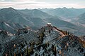
 Aerial view | |
| Highest point | |
| Elevation | 8,284 ft (2,525 m) [1] |
| Prominence | 1,324 ft (404 m) [2] |
| Parent peak | Gordon Mountain (8,369 ft) [2] |
| Isolation | 3.96 mi (6.37 km) [2] |
| Coordinates | 47°23′45″N113°09′54″W / 47.39597079°N 113.16493806°W [3] |
| Geography | |
 Jumbo Mountain Location in Montana  Jumbo Mountain Location in the United States | |
| Location | Powell County, Montana, U.S. |
| Parent range | Rocky Mountains Swan Range |
| Topo map | USGS Pilot Peak |
| Climbing | |
| Easiest route | trail |
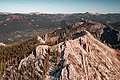
Jumbo Mountain is an 8,284-foot (2,525-metre) mountain summit located in Powell County of the U.S. state of Montana. [3]