Kalamazoo Township, Michigan

Last updated
Kalamazoo Township, Michigan
Charter Township of Kalamazoo
Kalamazoo Charter Township, MI location.png
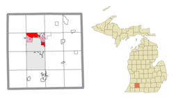
Location within Kalamazoo County and the administered CDPs of Eastwood (1), Westwood (2), and portion of Comstock Northwest (3)
USA Michigan location map.svg
Red pog.svg
Kalamazoo Township
Location within the state of Michigan
Usa edcp location map.svg
Red pog.svg
Kalamazoo Township
Location within the United States
Coordinates: 42°18′40″N85°35′17″W / 42.31111°N 85.58806°W / 42.31111; -85.58806
Country United States
State Michigan
County Kalamazoo
OrganizedJuly 30, 1830
Area
  Total11.79 sq mi (30.54 km2)
  Land11.68 sq mi (30.25 km2)
  Water0.11 sq mi (0.29 km2)
Elevation
771 ft (235 m)
Population
 (2020)
  Total22,777
  Density1,900/sq mi (750/km2)
Time zone UTC-5 (Eastern (EST))
  Summer (DST) UTC-4 (EDT)
Area code 269
FIPS code 26-42180 [1]
GNIS feature ID1626548 [2]
Website kalamazootownship.org

Kalamazoo Charter Township is a charter township of Kalamazoo County in the U.S. state of Michigan. The population was 22,777 at the 2020 census. [3]

Contents

The cities of Kalamazoo and Parchment are adjacent to the township and have annexed much land that was formerly within the township, such that the township now consists of two non-contiguous sections of land and one small section that is connected by a narrow point across Riverview Drive. Two census-designated places (CDPs) are within the township: Eastwood and Westwood. These are defined for statistical purposes and do not have any legal status as municipalities. However, both have an identity as communities, although the areas defined by the CDPs may not precisely correspond to local use of the terms. The CDPs can include nearby areas that locals might not consider as part of the community with the same name.

Kalamazoo Township was initially organized under the name of "Arcadia Township" by an act of the Territorial Legislature on July 30, 1830. A separate act on the same day organized the government of Kalamazoo County. Initially Arcadia Township consisted of all eight of the northern tier of townships in Kalamazoo County. In June 1832, Richland Township was set off, consisting of Richland, Ross, Charleston, and Comstock townships. On March 2, 1836, Arcadia Township was renamed as Kalamazoo Township, the same day that the village of Bronson was renamed as Kalamazoo. On March 11, 1837, Cooper Township was set off, consisting of Cooper and Alamo townships. On March 22, 1839, Oshtemo Township was set off from Kalamazoo. [4] [5]

Geography

According to the United States Census Bureau, the township has a total area of 11.8 square miles (30.5 km2), of which 11.7 square miles (30.3 km2) are land and 0.1 square miles (0.3 km2), or 0.95%, are water. [6]

Government

The government of the township provides a number of services to its residents including its police department, fire stations, building and inspection services, and a planning and zoning board. The township allows residents to attend public meetings as well as bimonthly board meetings to voice concerns. [7]

Committees, boards, and commissions

Demographics

As of the census [1] of 2000, there were 21,675 people, 9,349 households, and 5,338 families residing in the township. The population density was 1,856.4 inhabitants per square mile (716.8/km2). There were 9,856 housing units at an average density of 844.1 per square mile (325.9/km2). The racial makeup of the township was 82.46% White, 12.31% African American, 0.30% Native American, 1.17% Asian, 0.02% Pacific Islander, 1.61% from other races, and 2.13% from two or more races. Hispanic or Latino of any race were 3.07% of the population.

There were 9,349 households, out of which 25.9% had children under the age of 18 living with them, 42.4% were married couples living together, 10.9% had a female householder with no husband present, and 42.9% were non-families. 30.8% of all households were made up of individuals, and 10.9% had someone living alone who was 65 years of age or older. The average household size was 2.30 and the average family size was 2.89.

In the township the population was spread out, with 22.4% under the age of 18, 14.0% from 18 to 24, 29.8% from 25 to 44, 18.9% from 45 to 64, and 14.9% who were 65 years of age or older. The median age was 33 years. For every 100 females, there were 90.1 males. For every 100 females age 18 and over, there were 85.9 males.

The median income for a household in the township was $37,463, and the median income for a family was $46,161. Males had a median income of $35,993 versus $28,064 for females. The per capita income for the township was $19,844. About 6.0% of families and 11.0% of the population were below the poverty line, including 11.3% of those under age 18 and 2.7% of those age 65 or over.

Related Research Articles

<span class="mw-page-title-main">Kalamazoo County, Michigan</span> County in Michigan, United States

Kalamazoo County is a county located in the U.S. state of Michigan. As of 2020, the population was 261,670. The county seat is Kalamazoo.

<span class="mw-page-title-main">Calhoun County, Michigan</span> County in Michigan, United States

Calhoun County is a county in the U.S. state of Michigan. As of the 2020 Census, the population was 134,310. The county seat is Marshall. The county was established on October 19, 1829, and named after John C. Calhoun, who was at the time Vice President under Andrew Jackson, making it one of Michigan's Cabinet counties. County government was first organized on March 6, 1833. Calhoun County comprises the Battle Creek Metropolitan Statistical Area and is included in the Kalamazoo-Battle Creek-Portage Combined Statistical Area.

<span class="mw-page-title-main">Douglas, Michigan</span> City in Michigan, United States

Douglas is a city in Allegan County in the U.S. state of Michigan. The population was 1,378 at the 2020 census. The city is surrounded by Saugatuck Township and the city of Saugatuck is adjacent on the north.

Saugatuck Township is a civil township of Allegan County in the U.S. state of Michigan. The population was 3,443 at the 2020 census, up from 2944 at the 2010 census.

<span class="mw-page-title-main">Emmett Charter Township, Michigan</span> Charter township in Michigan, United States

Emmett Charter Township is a charter township of Calhoun County in the U.S. state of Michigan. It is part of the Battle Creek Metropolitan Statistical Area. The population was 11,744 at the 2020 census.

<span class="mw-page-title-main">Level Park–Oak Park, Michigan</span> Census-designated place & unincorporated community in Michigan, United States

Level Park–Oak Park is a census-designated place for statistical purposes in Calhoun County in the U.S. state of Michigan. The CDP population was 3,260 at the 2020 census. The CDP is immediately northwest of the city of Battle Creek and is part of the Battle Creek Metropolitan Statistical Area.

<span class="mw-page-title-main">Lansing Charter Township, Michigan</span> Charter township in Michigan, United States

Lansing Charter Township is a charter township of Ingham County in the U.S. state of Michigan. The population was 8,143 at the 2020 census.

<span class="mw-page-title-main">Alamo Township, Michigan</span> Civil township in Michigan, United States

Alamo Township is a civil township of Kalamazoo County in the U.S. state of Michigan. As of the 2020 census, the township population was 3,805.

<span class="mw-page-title-main">Charleston Township, Kalamazoo County, Michigan</span> Civil township in Michigan, United States

Charleston Township is a civil township of Kalamazoo County in the U.S. state of Michigan. The 2020 census recorded a population of 1,904, slightly down from 1,975 at the 2010 census.

<span class="mw-page-title-main">Comstock Township, Michigan</span> Charter township in Michigan, United States

Comstock Charter Township is a charter township of Kalamazoo County in the U.S. state of Michigan, located east of the city of Kalamazoo and is part of the Kalamazoo–Portage Metropolitan Area. The 2020 census recorded the population within the township at 15,231.

<span class="mw-page-title-main">Comstock Northwest, Michigan</span> Census-designated place & unincorporated community in Michigan, United States

Comstock Northwest is a census-designated place (CDP) in Kalamazoo County in the U.S. state of Michigan. The population was 5,455 at the 2010 census, up from 4,472 at the 2000 census.

<span class="mw-page-title-main">Eastwood, Michigan</span> Census-designated place & unincorporated community in Michigan, United States

Eastwood is an unincorporated community in Kalamazoo Charter Township, Kalamazoo County in the U.S. state of Michigan. It is a census-designated place (CDP) for statistical purposes and does not have any legal status as an incorporated municipality. The population was 6,340 at the 2010 census.

<span class="mw-page-title-main">Greater Galesburg, Michigan</span> Unincorporated community & former census-designated place in Michigan, United States

Greater Galesburg was a census-designated place (CDP) in Kalamazoo County in the U.S. state of Michigan, surrounding the city of Galesburg. As a CDP, it used for statistical purposes and does not have any legal status as a municipality. The population was 1,631 at the 2000 census. The CDP was deleted and not reported in the 2010 census

<span class="mw-page-title-main">Oshtemo Township, Michigan</span> Charter township in Michigan, United States

Oshtemo Charter Township is a charter township of Kalamazoo County in the U.S. state of Michigan. The 2020 census recorded a population of 23,747, up from 21,705 at the 2010 census. The township was organized in 1839.

<span class="mw-page-title-main">Pavilion Township, Michigan</span> Civil township in Michigan, United States

Pavilion Township is a civil township of Kalamazoo County in the U.S. state of Michigan. The population was 6,387 at the 2020 census, up from 6,222 at the 2010 census.

<span class="mw-page-title-main">South Gull Lake, Michigan</span> Census-designated place & unincorporated community in Michigan, United States

South Gull Lake is a census-designated place (CDP) in Ross Township, Kalamazoo County, in the U.S. state of Michigan. It includes the unincorporated communities of Yorkville, Gull Lake, and Midland Park and does not have any legal status as an incorporated municipality. The population of the CDP was 1,182 at the 2010 census, down from 1,526 at the 2000 census.

<span class="mw-page-title-main">Texas Charter Township, Michigan</span> Charter township in Michigan, United States

Texas Charter Township, officially named the Charter Township of Texas, is a charter township of Kalamazoo County, in the U.S. state of Michigan. As of the 2020 census, the township population was 17,691, up from 14,697 at the 2010 census. It encompasses the entire portion of the survey township T3S R12W.

<span class="mw-page-title-main">Westwood, Michigan</span> Census-designated place & unincorporated community in Michigan, United States

Westwood is an unincorporated community in Kalamazoo Charter Township, Kalamazoo County in the U.S. state of Michigan. It is a census-designated place (CDP) for statistical purposes and does not have any legal status as an incorporated municipality. The population was 8,653 at the 2010 census, down from 9,122 at the 2000 census.

<span class="mw-page-title-main">Republic, Michigan</span> Census-designated place & unincorporated community in Michigan, United States

Republic is an unincorporated community in Marquette County in the U.S. state of Michigan. It is also a census-designated place (CDP) for statistical purposes and no legal status as an incorporated municipality. The CDP had a population of 470 at the 2020 census, down from 570 in 2010. The community is located mostly within Republic Township with a small portion extending north into Humboldt Township.

<span class="mw-page-title-main">Crystal Lakes, Ohio</span> Census-designated place in Ohio, United States

Crystal Lakes is a census-designated place (CDP) in Clark County, Ohio, United States. The population was 1,394 at the 2020 census. It is part of the Springfield, Ohio Metropolitan Statistical Area.

References

  1. 1 2 "U.S. Census website". United States Census Bureau . Retrieved 2008-01-31.
  2. U.S. Geological Survey Geographic Names Information System: Kalamazoo Township, Michigan
  3. "Explore Census Data". data.census.gov. Retrieved 2024-04-21.
  4. A Brief History of the County, by George Torry, from the 1876 meeting of the Pioneer Society of the State of Michigan Archived February 16, 2009, at the Wayback Machine
  5. Chronology of Township, Village and City Formation, Kalamazoo County, MI Genealogy and Local History Archived February 7, 2009, at the Wayback Machine
  6. "Geographic Identifiers: 2010 Census Summary File 1 (G001), Kalamazoo charter township, Kalamazoo County, Michigan". American FactFinder. U.S. Census Bureau. Archived from the original on February 13, 2020. Retrieved March 29, 2019.
  7. "Government".