Karaungir

Last updated • 1 min readFrom Wikipedia, The Free Encyclopedia
Karaungir
Қараүңгір
Karaungir 2022-10-24-23 59 Sentinel-2 L2A True color.jpg
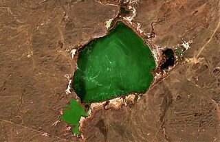
Sentinel-2 picture of the lake in late October
Relief Map of Kazakhstan.png
Red pog.svg
Karaungir
Location Kazakh Uplands
Coordinates 52°50′22″N69°40′59″E / 52.83944°N 69.68306°E / 52.83944; 69.68306
Type brackish lake
Basin  countries Kazakhstan
Max. length4.2 kilometers (2.6 mi)
Max. width3.3 kilometers (2.1 mi)
Surface area10.3 square kilometers (4.0 sq mi)
Average depth1.8 meters (5 ft 11 in)
Residence time UTC+5:00
Surface elevation361 meters (1,184 ft)
Islands no

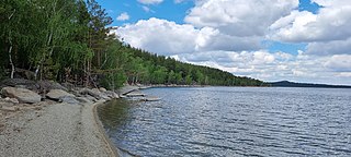
Karaungir (Kazakh : Қараүңгір) is a brackish lake in Zerendi and Burabay districts, Akmola Region, Kazakhstan. [1]

Contents

The village of Dorogovka lies 4.2 kilometers (2.6 mi) to the west, and Obaly (until 2019 — Pervomayskoye) 4.5 kilometers (2.8 mi) to the south. [2] [1] There is a leisure center on the southeastern lakeshore. [3]

Geography

Karaungir is located in the Kokshetau Mountains, Kazakh Uplands, and is part of the Irtysh basin. It lies at an elevation of 361 meters (1,184 ft). The lake has a roughly rectangular shape oriented in a north–south direction. There is a bay in the eastern shore enclosed by two landspits. The shores are surrounded by elevated terrain and they are regular and gently sloping. [1]

Among the lakes in Karaungir's vicinity, Kumdykol lies 11 kilometers (6.8 mi) to the east, Zhamantuz 20 kilometers (12 mi) to the north, Urymkay 26 kilometers (16 mi) to the southeast, Zerendi 35 kilometers (22 mi) to the WNW, and Aydabol 33 kilometers (21 mi) to the WSW. [2] [4]

Flora and fauna

Karaungir is surrounded by mountain steppe vegetation and patches of forest. The water is slightly saline, but it can be used for watering cattle in the spring after the melting of the snow. The salinity increases in the summer, especially in years of drought. [4]

See also

Related Research Articles

<span class="mw-page-title-main">Zerendi (lake)</span> Steppe lake in Kazakhstan

Lake Zerendі is a small lake in Zerendi District, Akmola Region, Kazakhstan.

<span class="mw-page-title-main">Urkash</span> Salt lake in Kazakhstan

Urkash is a lake in Kamysty District, Kostanay Region, Kazakhstan.

<span class="mw-page-title-main">Zharman</span> Lake in Kazakhstan

Zharman is a salt lake in Naurzum District, Kostanay Region, Kazakhstan.

<span class="mw-page-title-main">Kyzylkol</span> Lake in Kazakhstan

Kyzylkol is a lake in Sozak District, Turkestan Region, Kazakhstan.

<span class="mw-page-title-main">Kokshetau Lakes</span> Lakes of Kazakhstan

Kokshetau Lakes is a group of water bodies in the North Kazakhstan and Akmola regions, Kazakhstan.

<span class="mw-page-title-main">Kishi Shabakty</span> Lake in Kazakhstan

Kishi Shabakty is a lake in Burabay District, Akmola Region, Kazakhstan.

<span class="mw-page-title-main">Katynkol</span> Lake in Kazakhstan

Katynkol is a salt lake in Karkaraly District, Karaganda Region, Kazakhstan.

<span class="mw-page-title-main">Zhamantuz (lake, Akmola Region)</span> Lake in Kazakhstan

Zhamantuz is a salt lake in the Akmola Region, Kazakhstan.

<span class="mw-page-title-main">Shuga (lake)</span> Lake in Kazakhstan

Shuga is a salt lake in Zhanasemey District, Abai Region, Kazakhstan.

<span class="mw-page-title-main">Meshkeysor</span> Lake in Kazakhstan

Meshkeysor is a salt lake in Ulytau District, Ulytau Region, Kazakhstan.

<span class="mw-page-title-main">Koktinkoli</span> Lake in Kazakhstan

Koktinkoli is a lake in Shet District, Karaganda Region, Kazakhstan.

<span class="mw-page-title-main">Sharbakty (lake)</span> Lake in Kazakhstan

Sharbakty is a salt lake in Akkuly District, Pavlodar Region, Kazakhstan.

<span class="mw-page-title-main">Kotyrkol (Burabay District)</span> Lake in Kazakhstan

Kotyrkol, also known as "Katarkol" is a lake in Burabay District, Akmola Region, Kazakhstan.

<span class="mw-page-title-main">Balykty (Burabay District)</span> Lake in Kazakhstan

Balykty is a lake in Burabay District, Akmola Region, Kazakhstan.

<span class="mw-page-title-main">Urymkay</span> Lake in Kazakhstan

Urymkay or Urumkay is a lake in Burabay District, Akmola Region, Kazakhstan.

<span class="mw-page-title-main">Kumdykol (Burabay District)</span> Lake in Kazakhstan

Kumdykol is a freshwater lake in Burabay District, Akmola Region, Kazakhstan.

<span class="mw-page-title-main">Arshaly (river)</span> River in Kazakhstan

The Arshaly is a river in Zerendi and Astrakhan districts, Akmola Region, Kazakhstan. It has a length of 220 km (140 mi) and a basin size of 4,160 km2 (1,610 sq mi).

<span class="mw-page-title-main">Aydabol</span> Lake in Kazakhstan

Aydabol is a lake in Zerendi and Burabay districts, Akmola Region, Kazakhstan.

<span class="mw-page-title-main">Uzynkol</span> Lake in Kazakhstan

Uzynkol is a lake in Astrakhan District, Akmola Region, Kazakhstan.

<span class="mw-page-title-main">Katpagan</span> Lake in Kazakhstan

Katpagan is a salt lake in Amangeldi District, Kostanay Region, Kazakhstan.

References

  1. 1 2 3 "N-42 Topographic Chart (in Russian)" . Retrieved 30 October 2024.
  2. 1 2 Google Earth
  3. Природные места — Соленое озеро Караунгир
  4. 1 2 Nature of Kazakhstan Encyclopedia / General editor. B. O. Jacob. - Almaty: "Kazakh Encyclopedia" LLP, 2011. T.Z. - 304 pages. ISBN 9965-893-64-0 (T.Z.), ISBN 9965-893-19-5