Related Research Articles
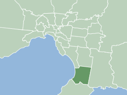
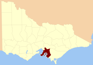
The City of Frankston is a local government area (LGA) in Victoria, Australia in the southern suburbs of Melbourne. It has an area of 130 square kilometres, and in June 2018, the City of Frankston recorded a population of 141,845.

The Mornington Peninsula is a peninsula located south of Melbourne, Victoria, Australia. It is surrounded by Port Phillip to the west, Western Port to the east and Bass Strait to the south, and is connected to the mainland in the north. Geographically, the peninsula begins its protrusion from the mainland in the area between Pearcedale and an area north of Frankston. The area was originally home to the Mayone-bulluk and Boonwurrung-Balluk clans, and formed part of the Boonwurrung nation's territory prior to European settlement.

Pearcedale is a township and coastal rural locality in Victoria, Australia, 49 km south-east of Melbourne's Central Business District, located within the City of Casey and the Shire of Mornington Peninsula local government areas. Pearcedale recorded a population of 3,867 at the 2021 census.

Carrum Downs is a suburb in Melbourne, Victoria, Australia, 48 km south-east of Melbourne's Central Business District via the Monash Freeway, located within the City of Frankston local government area. Carrum Downs recorded a population of 21,976 at the 2021 census.

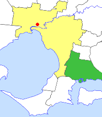
Frankston is a suburb in Melbourne, Victoria, Australia. Located 54 km (34 mi) south-east of the Melbourne city centre via EastLink and Monash Freeway, it is in the local government area of the City of Frankston and serves as its administrative and activity centres.
Langwarrin is a suburb in Melbourne, Victoria, Australia, 42 km (26 mi) south-east of Melbourne's Central Business District, located within the City of Frankston local government area. Langwarrin recorded a population of 23,588 at the 2021 census.
Skye is a suburb and semi-rural locality in Melbourne, Victoria, Australia, 48 km south-east of Melbourne's Central Business District via the Monash Freeway, located within the City of Frankston local government area. Skye recorded a population of 8,088 at the 2021 census.

Somerville is a town on the Mornington Peninsula in Melbourne, Victoria, Australia, 49 km (30 mi) south-east of Melbourne's Central Business District, located within the Shire of Mornington Peninsula local government area. Somerville recorded a population of 11,767 at the 2021 census.

Frankston railway station is a commuter railway station and the terminus of the Frankston line and the diesel-hauled services on the Stony Point line, which are part of the Melbourne railway network. It serves the south-eastern suburb of Frankston, in Melbourne, Victoria, Australia. Frankston station is a ground level premium station, featuring two side platforms, a terminus platform at platform 1 and platform 2 used for the terminus platform at the northern end of the platform and the Stony Point line services at the southern end of the platform. It opened on 1 August 1882, with the current station provided in 2018.

The Division of Dunkley is an Australian electoral division in the state of Victoria. The division is located south-east of Melbourne on the Mornington Peninsula. It covers an area of approximately 152 square kilometres (59 sq mi) from Seaford in the north to Mount Eliza in the south and Langwarrin South in the southeast. Following the 2024 Dunkley by-election, Jodie Belyea currently represents the seat.

Frankston South is a suburb in Melbourne, Victoria, Australia, 43 km south-east of Melbourne's Central Business District, located within the City of Frankston local government area. Frankston South recorded a population of 18,801 at the 2021 census.
The Mornington Peninsula Football Netball League (MPFNL), formerly known as the Mornington Peninsula Nepean Football League (MPNFL), is an Australian rules football competition, governed by the AFL South East. The MPFNL contains teams near the southeastern region of Melbourne, Victoria.
The County of Mornington is one of the 37 counties of Victoria which are part of the cadastral divisions of Australia, used for land titles. It is located to the south-east of Melbourne, including the Mornington Peninsula, French Island and Phillip Island. The county was proclaimed in 1849.
The City of Cranbourne was a local government area about 45 kilometres (28 mi) southeast of Melbourne, the state capital of Victoria, Australia. The city covered an area of 755 square kilometres (291.5 sq mi), and existed from 1860 until 1994. It was notable for being the last local government area to be declared a city prior to the large-scale amalgamations of 1994 – its former designation was the Shire of Cranbourne.

The City of Frankston was a local government area about 40 kilometres (25 mi) south of Melbourne, the state capital of Victoria, Australia. The city covered an area of 70.96 square kilometres (27.4 sq mi) in and around Frankston, and existed from 1860 until 1994.
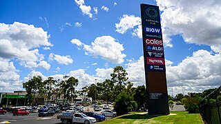
Karingal Hub Shopping Centre as well as its "Town Square" is the second largest shopping complex located at 330 Cranbourne Rd, Frankston, Victoria, Australia, approximately 40 kilometres (25 mi) south of Melbourne CBD. The complex has a combined gross leasable area of 53,000 m2 (570,000 sq ft), 2,750 parking spaces and 200+ stores. It was acquired by ISPT, or the Industry Superannuation Property Trust in July, 2013 and has been owned by other large corporations in the past such as Vicinity Centres, which owns its major competitor Bayside. It has the only Big W in and around the peninsula and has a multitude of popular shops, and includes a renovated and tall playground within its Town Square as well as an additional smaller playground in the south of the building, close to the retailer aforementioned.
Langwarrin South is a rural locality in Melbourne, Victoria, Australia, 47 km south-east of Melbourne's Central Business District, located within the City of Frankston local government area. Langwarrin South recorded a population of 1,346 at the 2021 census.
The Frankston Power Centre, also colloquially known as "The Power Centre", is a hard goods retail park run by Harvey Norman Holdings within the approximate centre of Frankston, being around 40 kilometres south of Melbourne's CBD. The complex comprises 30 large format independent stores, including parking for 1300 vehicles. Across from the complex are stores such as the hardware superstore Bunnings and JB Hi-Fi, but these are not run by the same company. The Centre is located at the crossroads of three major arterials of Frankston known as Cranbourne Road, McMahons Road and the Frankston Freeway.
References
- ↑ Phoenix Auctions History, Post Office List , retrieved 15 February 2021
- ↑ Jones, Michael. Frankston: Resort to City. Allen & Unwin: Sydney. 1989. ISBN 0-04-442114-1
- ↑ "NAMING OF "FRANKSTON."". The Argus . Melbourne: National Library of Australia. 30 May 1916. p. 9. Retrieved 19 September 2013.
- ↑ www.frankston.vic.gov.au https://www.frankston.vic.gov.au/Things-To-Do/Parks-and-Reserves/Karingal/Ballam-Park . Retrieved 8 July 2024.
{{cite web}}: Missing or empty|title=(help)