
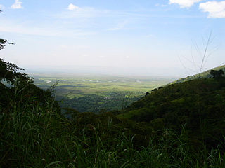
North Kivu is a province bordering Lake Kivu in the eastern Democratic Republic of the Congo. Its capital is Goma.

Kasese is a town north of Lake George in the Western Region of Uganda. It originally grew around the copper mine at Kilembe, while attention later turned to cobalt mining. It is the chief town of Kasese District, and the district headquarters are located there. Kasese is also the largest town in the Rwenzururu region. Charles Mumbere, the Omusinga of Rwenzururu, maintains a palace in the town.
Semliki River is a major river, 140 kilometres (87 mi) long, in the Democratic Republic of the Congo (DRC) and Uganda in Central and East Africa. It flows north from Lake Edward in Beni Territory, Nord-Kivu, D.R.C avoiding the Rwenzori Mountains on its Right (East), emptying into Lake Albert in the Albertine Rift, Irumu Territory, Ituri Province, D.R.C overlooking the Blue Mountains to its left in the west. Its mouth is near the Village of Katolingo in Kanara subcounty, Ntoroko district, Uganda. Along its lower reaches, it meanders extensively forming part of the international border between the DRC and the western Ugandan districts of Bundibugyo and Ntoroko, near the Semuliki National Park.
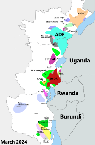
The Kivu conflict began in 2004 in the eastern Congo as an armed conflict between the military of the Democratic Republic of the Congo (FARDC) and the Hutu Power group Democratic Forces for the Liberation of Rwanda (FDLR) in the Democratic Republic of the Congo. It has broadly consisted of three phases, the third of which is an ongoing conflict. Prior to March 2009, the main combatant group against the FARDC was the National Congress for the Defence of the People (CNDP). Following the cessation of hostilities between these two forces, rebel Tutsi forces, formerly under the command of Laurent Nkunda, became the dominant opposition to the government forces.
Mpondwe is a town in the Western Region of Uganda.
Mweya is a location in the Western Region of Uganda.
Bunagana is a town in the Western Region of Uganda. It sits across the international border from the similarly named town of Bunagana, Democratic Republic of the Congo.

Bunagana, is a small town in Rutshuru Territory, North Kivu Province, in eastern Democratic Republic of the Congo, at the border with Uganda. It served as the headquarters of the M23 rebel militia in 2013 and is, since 13 June 2022, being occupied by March 23 Movement

The Allied Democratic Forces insurgency is an ongoing conflict waged by the Allied Democratic Forces in Uganda and the Democratic Republic of the Congo, against the governments of those two countries and the MONUSCO. The insurgency began in 1996, intensifying in 2013, resulting in hundreds of deaths. The ADF is known to currently control a number of hidden camps which are home to about 2,000 people; in these camps, the ADF operates as a proto-state with "an internal security service, a prison, health clinics, and an orphanage" as well as schools for boys and girls.
Rutshuru Hydroelectric Power Station, also referred to as Rutshuru Hydropower Station, is a 13.8-megawatt (18,500 hp) hydroelectric power station under construction in the Democratic Republic of the Congo. The plant was finished on December 16, 2015.

Lubero is a town in the North Kivu Province of the Democratic Republic of the Congo. It is the administrative center of the Lubero Territory. Following the surrender of the Mai-Mai fighters in 2021, construction of a new market began in 2022, involving the mayor, ex-soldiers, "young people at risk and the vulnerable women". As of March 2014, the population of Lubero is not publicly known.
Bugoye is a small town in Western Uganda.
Vurra is a town in Uganda.
Kikorongo, also Kikorongo Junctiom, is a settlement in Kasese District, in the Western Region of Uganda.
The Nkenda–Mpondwe–Beni High Voltage Power Line is a proposed high voltage electricity power line, connecting the high voltage substation at Nkenda, in Kasese District, in the Western Region of Uganda, to another high voltage substation at Beni, in North Kivu Province, in the Democratic Republic of the Congo.
The Mbarara–Kisangani Road is a road in Uganda and the Democratic Republic of the Congo, connecting the cities of Mbarara and Mpondwe in Uganda to Kasindi, Beni, Komanda and Kisangani in the Democratic Republic of the Congo.
Busengo is a settlement in the North Kivu Province of the Democratic Republic of the Congo. The town sits across the international border from Busengo, Uganda.
Bunagana–Rutshuru–Goma Road, is a road in Uganda and the Democratic Republic of the Congo, connecting the towns of Bunagana in Uganda with Bunagana in DRCongo. In addition the road connects these two towns to Bugani, Rutshuru, Rumangabo, Buhumba and Goma, all in DRCongo.
Kasindi–Beni–Butembo Road, is a road in the Democratic Republic of the Congo, connecting the towns of Kasindi, Beni and Butembo. The road allows interconnection between Uganda and DR Congo, facilitating trade, human interaction and enhancing joint security across the common border.
Ishasha is a town in the Democratic Republic of the Congo (DRC). The town sits across the Ishasha River, which acts as the international border, from the much smaller Ishasha Border Post, in neighboring Uganda. This town has seen much human translocations during the last decade of the 20th century and the first 20 years of the 21 century, as a result of refugees fleeing the two Congo Wars and the associated subsequent armed militia conflicts.
