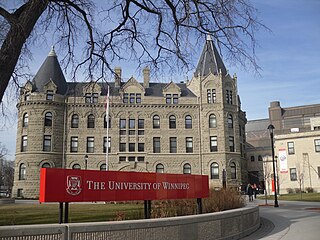
Winnipeg is the capital and largest city of the province of Manitoba in Canada. It is centred on the confluence of the Red and Assiniboine rivers, near the longitudinal centre of North America. As of 2021, Winnipeg had a city population of 749,607 and a metropolitan population of 834,678, making it Canada's sixth-largest city and eighth-largest metropolitan area.

Lake Winnipeg is a very large, relatively shallow 24,514-square-kilometre (9,465 sq mi) lake in North America, in the province of Manitoba, Canada. Its southern end is about 55 kilometres (34 mi) north of the city of Winnipeg. Lake Winnipeg is Canada's sixth-largest freshwater lake and the third-largest freshwater lake contained entirely within Canada, but it is relatively shallow excluding a narrow 36 m (118 ft) deep channel between the northern and southern basins. It is the eleventh-largest freshwater lake on Earth. The lake's east side has pristine boreal forests and rivers that were in 2018 inscribed as Pimachiowin Aki, a UNESCO World Heritage Site. The lake is 416 km (258 mi) from north to south, with remote sandy beaches, large limestone cliffs, and many bat caves in some areas. Manitoba Hydro uses the lake as one of the largest reservoirs in the world. There are many islands, most of them undeveloped.
Roblin is an unincorporated urban community in the Municipality of Roblin, Manitoba, Canada. It is located approximately 400 km (250 mi) northwest of Winnipeg.

Northern Manitoba is a geographic and cultural region of the Canadian province of Manitoba. Originally encompassing a small square around the Red River Colony, the province was extended north to the 60th parallel in 1912. The region's specific boundaries vary, as "northern" communities are considered to share certain social and geographic characteristics, regardless of latitude.

Gillam is a town on the Nelson River in northern Manitoba, Canada. It is situated between Thompson and Churchill on the Hudson Bay Railway line.
Snow Lake is a town in Manitoba, Canada, located 685 km north of Winnipeg at the end of Provincial Road 392. The main industry is, and always has been, mining; currently with one mine producing Zinc, and another lithium. The official Town of Snow Lake is a very large, overwhelmingly rural area that is centered about the urban community of Snow Lake, which lies very near its geographical center. The Town is as large in area as a typical rural municipality in the more southern parts of Manitoba.
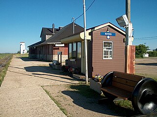
Rivers is an unincorporated urban community in the Riverdale Municipality within the Canadian province of Manitoba. It is located 40 kilometres (25 mi) northwest of Brandon, 473 metres (1,552 ft) above sea level. It is within the Westman Region. Agriculture, health and related businesses provide income for the community and area. Rivers has a population of 1,257 people in the 2016 census.
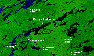
Cross Lake is a community in the Northern Region of the Canadian province of Manitoba, situated on the shores of the Nelson River where the river enters the namesake Cross Lake. An all-weather road, PR 374, connects the communities to PR 373 via the Kichi Sipi Bridge.
The Berens River is a river in the provinces of Manitoba and Ontario, Canada. It flows west from an unnamed lake in Kenora District, Ontario, and discharges its waters into Lake Winnipeg near the community and First Nation of Berens River, Manitoba. The river has a number of lakes along its course, and many rapids.

The Rural Municipality of Sifton is a rural municipality (RM) in the south-west portion of the Canadian province of Manitoba.
Nueltin Lake straddles the Manitoba—Nunavut border in Canada. The lake, which has an area of 2,279 km2 (880 sq mi), is predominantly in Nunavut's Kivalliq Region, and on the Manitoba side there is the Nueltin Lake Airport which serves the fishing lodge. The lake is split into two parts by a set of narrows. It is drained by the Thlewiaza River.

Kivallirmiut, also called the Caribou Inuit, barren-ground caribou hunters, are Inuit who live west of Hudson Bay in Kivalliq Region, Nunavut, between 61° and 65° N and 90° and 102° W in Northern Canada.
Cross Lake is a large lake in Manitoba on the Nelson River north of Lake Winnipeg. It is long and narrow and extends 102 kilometres (63 mi) east-northeast.
Touchwood Hills are a range of hills in the Canadian province of Saskatchewan. The hills are composed of the "Big" Touchwood Hills and the Little Touchwood Hills. Together they are referred to as the Touchwood Uplands. The hills are in the Prairie Pothole Region of North America, which extends throughout three Canadian provinces and five U.S. states, and within Palliser's Triangle and the Great Plains ecoregion of Canada.
Touchwood Hills Post Provincial Park is the location of a former Hudson's Bay Company (HBC) fur trading post that existed from 1879 to 1909 in the Touchwood Uplands of the Canadian province of Saskatchewan. In 1986, the site was designated a provincial park. It is located along Highway 15 in the RM of Kellross No. 247, about 10 kilometres (6.2 mi) west of Lestock and 16 kilometres (9.9 mi) east of Punnichy.

Manigotagan is a settlement in the Canadian province of Manitoba. It is located near the mouth of the Manigotagan River at Lake Winnipeg.

Split Lake is a lake on the Nelson River in Manitoba, Canada. The settlement of Split Lake is located on a peninsula on the northern shore. The lake is about 46 km long.
The Thlewiaza River is a river in Canada. Although some sources define the river as originating out of Nueltin Lake, according to the Canadian Geographical Names Database the river begins at Snyder Lake in northwestern Manitoba. From there the river flows northeast through Kasmere Lake into the southwest end of Nueltin Lake. It exits Nueltin Lake at its northern end in Nunavut and flows 275 kilometres (171 mi) east through Edehon Lake and Ranger Seal Lake before emptying into Hudson Bay. Its drainage basin covers an area of 64,399.6 square kilometres (24,864.8 sq mi).

Red Deer River is a river in the Canadian provinces of Saskatchewan and Manitoba. It has its source at Nut Lake in east central Saskatchewan and from there, it flows east towards Manitoba where it empties into Dawson Bay of Lake Winnipegosis. To the north of Red Deer's basin is the Saskatchewan River, to the south-west is the upper Assiniboine River, and to the south-east is Swan River.

