Kedarnath Wildlife Sanctuary

Last updated

Kedarnath Wildlife Sanctuary
केदारनाथ वन्य जीव अभ्यारण
India Uttarakhand location map.svg
Red pog.svg
Kedarnath Wildlife Sanctuary
Location in Uttarakhand, India
Coordinates: 30°36′00″N79°12′00″E / 30.60000°N 79.20000°E / 30.60000; 79.20000 Coordinates: 30°36′00″N79°12′00″E / 30.60000°N 79.20000°E / 30.60000; 79.20000
CountryFlag of India.svg  India
State Uttarakhand
District Chamoli Garhwal & Rudraprayag
Established1972
Area
  Total975 km2 (376 sq mi)
Elevation
1,160 m (3,810 ft)
Languages
  Official Hindi , Garhwali
Time zone UTC+5:30 (IST)
Nearest city Srinagar, Uttarakhand
IUCN category IV
Precipitation 3,093 mm (121.8 in)
Avg. summer temperature25 °C (77 °F)
Avg. winter temperature−10 °C (14 °F)

Kedarnath Wild Life Sanctuary, also called the Kedarnath Musk Deer Sanctuary, is a wildlife sanctuary declared under Wildlife Protection Act, 1972 and located in Uttarakhand, India. Its alternate name comes from its primary purpose of protecting the endangered Himalayan musk deer. [1] Consisting of an area of 975 km2 (376 sq mi), it is the largest protected area in the western Himalayas.It is famous for alpine musk deer, Himalayan Thar, Himalayan Griffon, Himalayan Black bear, Snow Leopard and other flora park and fauna. It is internationally important for the diversity of its flora and fauna (particularly of ungulate species). [2] [3]

Contents

Located in the Himalayan Highlands with an elevation ranging from 1,160 metres (3,810 ft) (near Phata) to the Chaukhamba peak at 7,068 m (23,189 ft), it was a notified reserve forest between 1916 and 1920. It was changed to a sanctuary on 21 January 1972, and has been designated a "Habitat/Species Management Area" by the IUCN. [1] [2]

The sanctuary straddles a geographically diverse landscape and transitional environment. [4] [5] IUCN has reported that "From 44.4% to 48.8% of the sanctuary is forested, 7.7% comprises alpine meadows and scrub, 42.1% is rocky or under permanent snow and 1.5% represents formerly forested areas that have been degraded." [2]

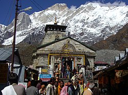
The sanctuary takes its name from the famous Hindu temple of Kedarnath which is just outside its northern border. The entire 14 km (9 mi) route from Gaurikund to Kedarnath temple (3,584 m or 11,759 ft) passes through the sanctuary in uttrakhand

Geography

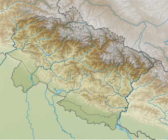
The sanctuary is geographically situated in the Chamoli and Rudraprayag districts of Uttarakhand. It lies within the larger Western Himalayan alpine shrub and meadows of alpine ecoregion of India, Nepal and Tibet, [6] The sanctuary is at its higher altitudes is characterised by glaciers which through glacial action over centuries have created deep "v" shaped valleys. [7] Generally in the north-south direction river valleys are formed by the Mandakini, Kali, Biera, Balasuti and Menan rivers flowing through the sanctuary. The geological formation in the catchment is made up of "Central Crystallines" that are metamorphic rocks such as gneisses, granites and schists. [2] [3] Lakes, waterfall and high-rise mountain peaks abound in this forest belt, as do a number of old Hindu pilgrimage sites - Madhyamaheshwar, Tungnath, Rudranath, Kedarnath, Triyuginarayan and Kalpeshwar all are located within or on the periphery of the sanctuary.

Religious and social aspect

Kedarnath temple gives its name to the sanctuary as it is located amidst the temple precincts Kedarnathji-mandir.JPG
Kedarnath temple gives its name to the sanctuary as it is located amidst the temple precincts

The sanctuary has a large number of Hindu temples located within its precincts. Kedarnath temple is the most historic of these and is visited by a very large number of pilgrims. [8] This temple dates to the 8th century. Other temples, though not of matching importance, have strong legends related to the epic Mahabharata days. These are the Mandani, Madhyamaheshwar, Tungnath, Ansuya Devi and Rudranath. The local Hindu culture is also imbibed by the Bhotiyas (may be with some Tibetan link) who have pastoral work culture and are an integral part of the valleys. [2] [3] [9] Visitors to these temples have occasionally been attacked by wildlife. [2]

Climate

A typical temperate to sub-arctic climate prevails in the locale of the sanctuary. The South West summer monsoon rains recorded is the mean annual precipitation of 3,093 mm (122 in). This high value of precipitation is due to the fact that the hill ranges to the south, of about 3,000 m (9,800 ft) height, are open without much of rain-shadow effect. On the basis of rainfall of 3,050 mm (120 in) recorded near Tungnath in 1979-81, the monsoon rain (June to September) was about 81% while snow precipitation during December–March was 11%. Summer temperature recorded is 25 °C (77 °F), the highest in May or June; a mild and pleasant condition. The lowest winter temperature recorded in the first half of January is −10 °C (14 °F), when heavy snowfall is received in the upper region. This results in severe cold conditions. For about three months, following heavy snowfall in December, the sanctuary is snow-covered. [2] [7]

Flora

The sanctuary is reputed to be one of the world's richest bio-reserves. [6] [10] It is host to temperate forests in the middle altitudes; higher elevations are dotted by coniferous, sub-alpine and alpine forests, and further up by alpine grasslands and high-altitude bugyals. The diverse climate and topography in the sanctuary area has created dense forests of chir pine, oak, birch, rhododendrons and alpine meadows with incidence of numerous Himalayan flowering plants. [1] At Tungnath, two sedges, Carex lacta and C. munda , have been reported which had previously only been reported in the far west region of Nepal. [2] [7] The sanctuary is reputed to have many high value medicinal and aromatic plant species, of which 22 species are rare and endangered. Aconitum balfourii , Angelica glauca , Arnebia benthamii , Artemisia maritima , Bergenia stracheyi , and Dactylorhiza hatagirea are among the threatened medicinal plant species of the sanctuary. [11]

Fauna

The sanctuary is rich in faunal, avifaunal and aquafaunal species (some are pictured in the gallery). [1] [2] [8] [9] [12]

Mammals

Birds

Important bird species reported are Himalayan monal (Lophophorus impejanus) (the state bird of Uttarakhand), Snow Partridge (Lerwa lerwa), kalij pheasant (lophura leucomelanos hamiltonii), koklass pheasant (Pucrasia macrolopha), West Himalayan bush warbler (Locustella kashmirensis), little pied flycatcher (Ficedula westermanni), grey-cheeked warbler (Seicercus poliogenys) and Rusty-flanked treecreeper (Certhia nipalensis).

Reptiles

Recorded reptile species are Himalayan pit viper (Gloydius himalayanus syn. Ancistrodon himalayanus) (common) and Boulenger's keelback ( Hebius parallelum ).

Fish

In the Mandakini river, fishes recorded include Schizothorax sp., mahseer ( Tor tor , Labeo spp., Garra spp., Barilius spp., a new species of Nemacheilus , Glyptothorax spp. and Balitora brucei . [2]

Conservation

Among the more notable of the animals in the region is the animal for which it is alternatively named; the musk deer. Declining population (over 40% in 21 years) of this species and large scale poaching for profit, dictated the decision to declare it as an endangered animal (EN) in 1973 (Halloway, 1973) and the species was listed vulnerable in the red data book of IUCN in 1974. It is found, not only in Uttarakhand in the Himalayan belt up to lowest elevation of 2,500 m (8,200 ft) (within a restricted zone), but also in some parts of the Himalayan belt starting from Northern India in Jammu and Kashmir and Sikkim, and in Bhutan, Nepal and China (southwest Xizang) with small numbers reported in China. [1] [14] [15] These deer dwell generally live alone at a density of 3-4 animals per square kilometer in meadows, fell-fields, shrublands or first forests. [14]

The male species of the endangered musk deer in the Kedarnath Wildlife Sanctuary carries the much valued pods musk pod (glands). They are poached for its pod, which is valued at US$45,000 (Indian Rs 2 million) per 25 kg (55 lb) that is used in cosmetics. It has reportedly pharmaceutical properties also. Its meat is also consumed as a delicacy. [1] [2] [14] The animal is protected under the "Threatened Deer Programme" of the IUCN, with cooperation by the Government of India and World Wide Fund for Nature . [15] The sanctuary includes a breeding center at Kharchula Kharak, both to help advance understanding of the animal's conservation requirements and to breed it in captivity for reintroduction to the wild. Through 1987, it had successfully reared nine deer. [1] [2] [3] [15] [16]

Other scientific activities centered around the sanctuary have been: the high-altitude botanical field station established at Tungnath (3,500 m or 11,500 ft) by the Garhwal University; further ecological studies of the ungulates; WWF on ecology of the Himalayan musk deer and other ungulates near Tungnath, together with surveys of the mammalian fauna and avifauna; and fish fauna studies in the Mandakini River. [2]

Management of sanctuary

The management of the wildlife sanctuary is done by the Uttarakhand Forest department. The Divisional Forest Officer(DFO) Kedarnath Wildlife Division is responsible for scientific management of the wildlife sanctuary as per the approved management plan. The headquarter of Kedarnath Wildlife Division is located at Gopeshwar, District Chamoli. The permission of trekking, camping or conducting scientific study inside the sanctuary is provided by DFO Kedarnath. Wildlife Division. The management of the wildlife sanctuary focuses mainly on wildlife habitat improvement, grazing regulation, forest protection and conservation.

Visitor information

Visitors are mostly Indian nationals on pilgrimage to various temples, though a few international tourists also visit the area. The approach to Kedarnath Temple is only through the sanctuary. Visiting season is from April to June and again from September to November. The number of visitors to the Kedarnath shrine, who passed through the sanctuary, was 5,57,923 in 2007 as against 87,629 in 1987, a quantum jump in 20 years. [2] [17]

The nearest airport is at Jolly Grant Airport at Dehradun at a distance of 227 km (141 mi) from Chopta, the entry point to the sanctuary. Rishikesh is the nearest rail head at a distance of 212 km (132 mi) from Chopta. National Highway NH 58 from Delhi passes through Chamoli via Meerut, Muzaffarnagar, Roorkee, Haridwar, Rishikesh, Devprayag, Srinagar, Rudraprayag, Okhimath; and by state highway to Chopta. [10]

The sanctuary and surroundings offer some housing for visitors, including the forest hut at Madhyamaheshwar for which prior reservation needs to be done through the DFO, Kedarnath Wildlife Division, Gopeshwar. The Temple Committee maintains Dharamshalas (rest houses or inns) for use by pilgrims and tourists at Trijuginarayan, Dougalbitta, Mandal, Gaurikund and Kedarnath. There is also a guest house at Sonprayag. [2] [18] [19]

Sanctuary landscape

Related Research Articles

Kedarnath Town in Uttarakhand, India

Kedarnath is a town in Rudraprayag District in the State of Uttarakhand in India and has gained importance because of the Kedarnath Temple. It is approximately 86 kilometres from Rudraprayag, the district headquarter. It is a Nagar panchayat in the Rudraprayag district. Kedarnath is the most remote of the four Chota Char Dham pilgrimage sites. It is located in the Himalayas, about 3,583 m (11,755 ft) above sea level near the Chorabari Glacier, which is the source of the Mandakini river. The town is flanked by snow-capped peaks, most prominently the Kedarnath Mountain. The nearest road head is at Gaurikund about 16 km away. The town suffered extensive destruction during June 2013 from the Flash Floods caused by torrential rains in Uttarakhand state.

Valley of Flowers National Park National park in Uttarakhand, India

Valley of Flowers National Park is an Indian national park, located in Chamoli in the state of Uttarakhand and is known for its meadows of endemic alpine flowers and the variety of flora. This richly diverse area is also home to rare and endangered animals, including the Asiatic black bear, snow leopard, musk deer, brown bear, red fox and blue sheep. Birds found in the park include Himalayan monal pheasant and other high altitude birds.

Himalayan monal Species of bird

The Himalayan monal, also known as the Impeyan monal and Impeyan pheasant, is a pheasant native to Himalayan forests and shrublands at elevations of 2,100–4,500 m (6,900–14,800 ft). It is part of the family Phasianidae and is listed as Least Concern on the IUCN Red List. It is the national bird of Nepal, where it is known as the danphe or danfe, and state bird of Uttarakhand, India, where it is known as monal. The scientific name commemorates Lady Mary Impey, the wife of the British chief justice of Bengal, Sir Elijah Impey.

Dachigam National Park National park in Jammu and Kashmir

Dachigam National Park is located 22 kilometers from Srinagar, Jammu and Kashmir. It covers an area of 141 km2. The name of the park literally stands for "ten villages" which is in the memory of the ten villages that were relocated for its formation. These ten villages were living in this region before the World War I the beginning of the early 20th century. The main gate entrance is very close to the New Theed general bus stand on the either side of Darul Uloom Kousaria.

Gangotri National Park Indian national park

Gangotri National Park is a national park in Uttarkashi District of Uttarakhand in India, covering about 2,390 km2 (920 sq mi). Its habitat consists of coniferous forests, alpine meadows and glaciers. Gaumukh at Gangotri glacier, the origin of river Ganga, is located inside the park. Gangotri National Park was established in 1989.

Rudraprayag district District of Uttarakhand in India

Rudraprayag is a district of the state of Uttarakhand of northern India. The district occupies an area of 1984 km2. The town of Rudraprayag is the administrative headquarters of the district. The district is bounded by Uttarkashi District on the north, Chamoli District on the east, Pauri Garhwal District on the south, and Tehri Garhwal District on the west.

Triyuginarayan Temple Hindu Temple in Uttarakhand, India

Triyuginarayan Temple is a Hindu temple located in the Triyuginarayan village in Rudraprayag district, Uttarakhand, India. The ancient temple is dedicated to god Vishnu. Its fame is credited to the legend of god Shiva’s marriage to goddess Parvati witnessed by Vishnu at this venue and is thus a popular Hindu pilgrimage sites. A special feature of this temple is a perpetual fire, that burns in front of the temple. The flame is believed to burn from the times of the divine marriage. Thus, the temple is also known as Akhand Dhuni temple.

Rudraprayag Town in Uttarakhand, India

Rudraprayag is a town and a municipality in Rudraprayag district in the Indian state of Uttarakhand. Rudraprayag is one of the Panch Prayag of Alaknanda River, the point of confluence of rivers Alaknanda and Mandakini. Kedarnath, a Hindu holy town is located 86 km from Rudraprayag. The man-eating Leopard of Rudraprayag hunted and written about by Jim Corbett dwelled here.

Mandakini River River in India

The Mandakini River is a tributary of the Alaknanda River in the Indian state of Uttarakhand. The river runs for approximately 81 kilometres (50 mi) between the Rudraprayag and Sonprayag areas and emerges from the Chorabari Glacier. The river merges with river Songanga at Sonprayag and flows past the Hindu temple Madhyamaheshwar at Ukhimath. At the end of its course it drains into the Alaknada, which flows into the Ganges.

Tungnath Hindu Temple in Uttarakhand, India

Tungnath (Sanskrit:तुंगनाथ) (IAST:tuņgnāth) is one of the highest Shiva temples in the world and is the highest of the five Panch Kedar temples located in the Rudraprayag district, in the Indian state of Uttarakhand. The Tungnath mountains form the Mandakini and Alaknanda river valleys. It is located at an altitude of 3,470 m (11,385 ft), and just below the peak of Chandrashila. and is the second in the pecking order of the Panch Kedars. It has a rich legend linked to the Pandavas, heroes of the Mahabharata epic.

Western Himalayan alpine shrub and meadows

The Western Himalayan alpine shrub and meadows is a montane grasslands and shrublands ecoregion of Nepal, India, and Tibet, which lies between the tree line and snow line in the western portion of the Himalaya Range.

Kazinag National Park or Qazinag National Park is a commissioned future national park in the Baramulla district in the Indian union territory of Jammu and Kashmir. It is part of a proposal for a trans-Karakoram peace park with Pakistan. Kazinag national park located in North region of kashmir.

Panch Kedar Group of five Shiva Temples in Uttarakhand, India.

Panch Kedar refers to five Hindu temples or holy places of the Shivaite sect dedicated to god Shiva. They are located in the Garhwal Himalayan region in Uttarakhand, India. They are the subject of many legends that directly link their creation to Pandavas, the heroes of the Hindu epic Mahabharata.

Madhyamaheshwar Hindu temple in Gaundar village, Uttarakhand, India

Madhyamaheshwar or Madmaheshwar is a Hindu temple dedicated to the Hindu god, Shiva, located in the Goundar village of Garhwal Himalayas in Uttarakhand, India. Situated at an elevation of 3,497 m (11,473.1 ft), It is one of the Panch Kedar pilgrimage circuit, comprising five Shiva temples in the Garhwal region. The other temples in the circuit include: Kedarnath, Tungnath and Rudranath to be visited before Madhyamaheshwar and Kalpeshwar to be visited after Madhyamaheshwar. The middle (madhya) or belly part or navel (nabhi) of Shiva, is worshipped at this temple, believed to be built by the Pandavas, the survivors of the Hindu epic Mahabharata.

Guptakashi, Gupta Kashi or Guptkashi is a fairly large town located at an elevation of 1,319 metres (4,327 ft) in the Kedar-khanda, in Garhwal Himalayas of Rudraprayag district in Uttrakhand, India. It is known for its ancient Vishwanath Temple dedicated to the god Shiva, which is similar to the one in Varanasi (Kashi). The other well known temple here is dedicated to Ardhanareshvara, a half man half woman form of Shiva and Parvati. The name Guptakashi has legendary significance linked to the Pandavas, the heroes of the Hindu epic Mahabharata. Its religious importance is considered next to that of Varanasi, believed to be the most pious of all Hindu pilgrimage sites.

Chandrashila

Chandrashila is the summit above Tungnath temple. It literally means "Moon Rock". It is located at a height of about 3,690 metres (12,110 ft) above sea level. This peak provides views of the Himalayas, including Nandadevi, Trisul, Kedar Peak, Bandarpunch and Chaukhamba peaks. There are various legends associated with this place. According to one such legend, this is the place where Lord Rama meditated after defeating the demon-king Ravana. Another legend says that moon-god Chandra spent time here in penance.

Chopta Village in Uttarakhand, India

Chopta is a small region of meadows and evergreen forest area, a part of Kedarnath wildlife sanctuary located in Uttarakhand state, India and a base for trekking to Tungnath, the third temple of Panch Kedar which lies 3.5 kilometres (2.2 mi) away. Located at a distance of 1.5 kilometres (0.93 mi) from Tungnath is Chandrashila, a summit rising to over 4,000 metres (13,000 ft).

Western Himalayan broadleaf forests

The Western Himalayan broadleaf forests is a temperate broadleaf and mixed forest ecoregion which is found in the middle elevations of the western Himalayas, including parts of Nepal, India, and Pakistan.

Gulmarg Wildlife Sanctuary Wildlife Sanctuary in Gulmarg

The Gulmarg Wildlife Sanctuary spread over 180 square kilometres (69 sq mi) is a protected area in Baramulla district of Jammu and Kashmir, India. The sanctuary lies on the north-eastern side of the Pir Panjal mountain range and falls under the northwest Biogeographic Zone 2A. It lies 50 kilometres (31 mi) south-west of Srinagar and 26 kilometres (16 mi) from Baramulla. The sanctuary was first declared as a game reserve in 1981 and later upgraded to a sanctuary in 1987.

Chopta Bugyal

Chopta Bugyal, also known as "Tungnath Bugyal" or "Rohini Bugyal", is a cluster of Bugyals in Chopta, Rudraprayag district of Uttarakhand. Chopta Bugyal is a trekking and camping destination. The Bugyal has an average elevation of 2,849 m and is around 30 km from Ukhimath. It is situated on the trek route to Tungnath, the third temple of the Panch Kedar and the highest Shiva temple in the world and Chandrashila, a summit at an altitude of 3,645 m. Chopta Bugyal is surrounded by forests of pine, deodar and rhododendron and is rich in flora and fauna.

References

  1. 1 2 3 4 5 6 7 Roma Bradnock (2004). Foot Print, India. Kedarnath Musk Deer Sanctuary. Footprint Travel Guides. p. 231. ISBN   978-1-904777-00-7.
  2. 1 2 3 4 5 6 7 8 9 10 11 12 13 14 15 "Kedarnath Sanctuary". UNEP & WCMC. Archived from the original on 18 May 2009. Retrieved 17 July 2009.
  3. 1 2 3 4 "Uttarakhand (Uttaranchal)" (PDF). Kedarnath Temple trek. pp. 27 of 43.
  4. "Uttaranchal SoE November 2004" (PDF). state of the environment. Uttranchal Environment and Pollution Control Board. pp. 15–16. Archived from the original (PDF) on 21 July 2011. Retrieved 18 July 2009.
  5. "Rudraprayag" . Retrieved 18 July 2009.
  6. 1 2 "Western Himalayan alpine shrub and meadows". Terrestrial Ecoregions. World Wildlife Fund. Retrieved 18 July 2009.
  7. 1 2 3 Sharad Singh Negi (1993). Himalayan wildlife, habitat and conservation. Kedarnath Musk Deer Sanctuary. Indus Publishing. pp. 171–172. ISBN   978-81-8518-268-1 . Retrieved 18 July 2009.
  8. 1 2 "Kedartnath Sanctuary" . Retrieved 18 July 2009.
  9. 1 2 P.C. Sinha (2005). Encyclopaedia of Travel, Tourism and Ecotourism. Kedarnath Musk deer. Anmol Publications PVT. LTD. pp. 166–167. ISBN   978-81-261-2398-8 . Retrieved 18 July 2009.
  10. 1 2 "Kedarnath Musk Deer Sanctuary - Wild Beauty" . Retrieved 18 July 2009.
  11. Kala, C.P. Conservation Biology, 2005, 19: 368-378http://onlinelibrary.wiley.com/doi/10.1111/j.1523-1739.2005.00602.x/abstract
  12. Sharad Singh Negi (2002). Handbook of national parks, wildlife sanctuaries and biosphere reserves in India. Kedarnath Musk deer Wild Life sanctuary. Indus Publishing. p. 165. ISBN   978-81-7387-128-3.
  13. Times, Hindustan. "Tiger spotted in Kedarnath at 3,400m altitude".
  14. 1 2 3 "Moschus leucogaster". IUCN Red List of Threatened Species 2009.1. Retrieved 18 July 2009.
  15. 1 2 3 C.Tiwari; Bhagwati Joshi (1997). Wildlife in the Himalayan foothills. Indus Publishing. pp. 125 of 376. ISBN   978-81-7387-066-8 . Retrieved 20 July 2009.
  16. "Uttaranchal 09". Scribd. Retrieved 20 July 2009.
  17. "Number Of Pilgrims". Archived from the original on 21 July 2011. Retrieved 20 July 2009.
  18. "Kedarnath Wildlife Sanctuary". Archived from the original on 27 August 2008. Retrieved 18 July 2009.
  19. "Kedarnath Wildlife Sanctuary". Archived from the original on 26 July 2011. Retrieved 18 July 2009.