
Harpers Ferry, population 286 at the 2010 census, is a historic town in Jefferson County, West Virginia, United States, in the lower Shenandoah Valley. It is situated at the confluence of the Potomac and Shenandoah rivers, where the U.S. states of Maryland, Virginia, and West Virginia meet. It is the easternmost town in West Virginia and during the Civil War the northernmost point of Confederate-controlled territory. The town's original, lower section is on a flood plain created by the two rivers and surrounded by higher ground.

Jefferson County is located in the Shenandoah Valley and is the easternmost county of the U.S. state of West Virginia. As of the 2010 census the population was 53,498. Its county seat is Charles Town. The county was founded in 1801, and today is part of the Washington metropolitan area.

Martins Ferry is a city in Belmont County, Ohio, United States, on the Ohio River across from Wheeling, West Virginia. It is the largest city in Belmont County. The population was 6,915 as of the 2010 census.

Cape Charles is a town / municipal corporation in Northampton County, Virginia, United States. The population was 1,009 as of the 2010 U.S.Decennial Census.

The Dry Tortugas are a small group of islands, located in the Gulf of Mexico at the end of the Florida Keys, United States, about 67 miles (108 km) west of Key West, and 37 miles (60 km) west of the Marquesas Keys, the closest islands. Still farther west is the Tortugas Bank, which is submerged. The first Europeans to discover the islands were the Spanish in 1513, led by explorer Juan Ponce de León. The archipelago's name derives from the lack of fresh water springs, and the presence of turtles. They are an unincorporated area of Monroe County, Florida, and belong to the Lower Keys Census County Division. With their surrounding waters, they constitute the Dry Tortugas National Park.

Virginia Key is an 863-acre (3.49 km2) barrier island in Miami, Florida, United States in Biscayne Bay, south of Brickell and north of Key Biscayne. It is accessible from the mainland via the Rickenbacker Causeway.
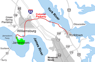
The Historic Triangle includes three historic colonial communities located on the Virginia Peninsula of the United States and is bounded by the York River on the north and the James River on the south. The points that form the triangle are Jamestown, Colonial Williamsburg, and Yorktown. They feature many restored attractions and are linked by the Colonial Parkway in James City and York counties, and the City of Williamsburg.

Harpers Ferry National Historical Park is located at the confluence of the Potomac and Shenandoah rivers in and around Harpers Ferry, West Virginia. The park includes land in the Shenandoah Valley in Jefferson County, West Virginia; Washington County, Maryland and Loudoun County, Virginia. The park is managed by the National Park Service, an agency of the U.S. Department of the Interior. Originally designated Harpers Ferry National Monument in 1944, the park was declared a National Historical Park by the U.S. Congress in 1963. The park includes the historic town of Harpers Ferry, notable as a center of 19th-century industry and as the scene of John Brown's failed abolitionist uprising. Consisting of almost 4,000 acres (16 km2), it includes the site of which Thomas Jefferson once wrote, "The passage of the Potomac through the Blue Ridge is perhaps one of the most stupendous scenes in Nature" after visiting the area in 1783. Due to a mixture of historical events and ample recreational opportunities, all within 50 miles (80 km) of Washington, D.C., the park was listed on the National Register of Historic Places on October 15, 1966. The Park's Superintendent is presently Tyrone Brandyburg.
Little Cacapon is an unincorporated community in Hampshire County in the U.S. state of West Virginia. Little Cacapon is located at the mouth of the Little Cacapon River on the Potomac, east of Okonoko. Okonoko-Little Cacapon Road and Spring Gap-Neals Run Road converge south of Little Cacapon. Because of its key location at the mouth of the Little Cacapon and on the Baltimore and Ohio Railroad, Little Cacapon played important roles in both the French and Indian and American Civil Wars. Generally pronounced kə-KAY-pən. Sometimes, despite the current spelling of the word some locals say KAY-pən.
Gallipolis Ferry is a census-designated place (CDP) in Mason County, West Virginia, USA. It is situated on the Ohio River along West Virginia Route 2. As of the 2010 census, its population was 817. It is the site of the Robert C. Byrd Locks & Dam on the Ohio. The community was named for the fact a ferry once provided service between the town site and nearby Gallipolis, Ohio.

The Rickenbacker Causeway is a causeway which connects Miami, Florida, United States to the barrier islands of Virginia Key and Key Biscayne across Biscayne Bay.
Carnifex Ferry Battlefield State Park is an American Civil War battle site that commemorates the Battle of Carnifex Ferry. It is located on the rim of the Gauley River Canyon near Summersville, a town in Nicholas County, West Virginia. The 156-acre (0.63 km2) park features Patterson House Museum, three views of the Gauley River, hiking trails and picnic facilities. It is one of the oldest state parks in the United States. A Civil War reenactment takes place on a weekend after Labor Day. As Carnifex Ferry State Park, it was listed on the National Register of Historic Places in 1974.

Neersville is an unincorporated community in northwestern Loudoun County, Virginia, United States. It is located in the Between the Hills area of the Loudoun Valley on Harpers Ferry Road at the foot of Short Hill Mountain. It is notable for being the birthplace of Confederate guerrilla John Mobberly.
Harpers Ferry Armory, more formally known as the United States Armory and Arsenal at Harpers Ferry, was the second federal armory commissioned by the United States government. It was located in Harpers Ferry, West Virginia, while the first federal armory was the Springfield Armory located in Springfield, Massachusetts. In many books, the town is called "Harper's Ferry" with an apostrophe.
Chief Cornstalk Wildlife Management Area is located on 11,772 acres (4,764 ha) in Mason County near Southside, West Virginia. Second growth oak-hickory and mixed hardwoods forests cover much of the rolling and moderately steep slopes. Chief Cornstalk WMA can be reached either on Nine Mile Creek Road off US 35 near Southside, or by Crab Creek Road from State Route 2, south of Gallipolis Ferry.

"Mount Winans" is a mixed-use residential, commercial and industrial neighborhood in the southwestern area of the City of Baltimore in Maryland. Its north, south and east boundaries are marked by the various lines of track of the CSX Railroad. In addition, Hollins Ferry Road running to the south towards suburban Baltimore County in the southwest and further connecting with adjacent Anne Arundel County to the southeast, draws its western boundary.
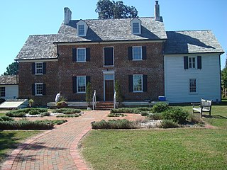
Ferry Plantation House, or Old Donation Farm, Ferry Farm, Walke Manor House, is a brick house in the neighborhood of Old Donation Farm, Virginia Beach in Virginia Beach, Virginia. The site dates back to 1642 when Savill Gaskin started the second ferry service in Hampton Roads to carry passengers on the Lynnhaven River to the nearby county courthouse and to visit plantations along the waterway. A cannon was used to signal the ferry, which had 11 total stops along the river. The first ferry service was started nearby by Adam Thoroughgood. [citation needed]

Ferry Point Park is a 413.8-acre (167.5 ha) park in the Bronx, New York City. The park site is a peninsula projecting into the East River roughly opposite the College Point and Malba neighborhoods of Queens. The park is located on the eastern shore of Westchester Creek, adjacent to the neighborhood of Throggs Neck. The park is operated by the New York City Department of Parks and Recreation. The Hutchinson River Expressway crosses the park to the Bronx-Whitestone Bridge, splitting it into east and west sides.

Queens West is a district and redevelopment project along the East River in Long Island City, Queens, New York City. The project, located on Hunter's Point south of the Anable Basin, is a joint project sponsored by the Port Authority of New York & New Jersey (PANYNJ) and the Empire State Development Corporation (ESD). The Queens West Development Corporation (QWDC), a subsidiary of ESD, was established in 1992 to facilitate implementation of the approved development plan.


