
Mirzapur is a city in Uttar Pradesh, India. It is known for its carpets and brassware industries, and the tradition of kajari and birha music. Straddled by the Maikal Hills, it served as the headquarters of the Mirzapur district.

The Vindhya Range is a complex, discontinuous chain of mountain ridges, hill ranges, highlands and plateau escarpments in west-central India.
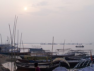
Vindhyachal is a city in Mirzapur district of the Indian state of Uttar Pradesh. The city is a Hindu pilgrimage site having the temple of Vindhyavasini, who according to Markandeya Purana, had incarnated to kill the demon Mahishasura. A detailed description has been given in the 'Durga Saptashati' chapter of the Markandeya Purana. The river Ganga flows through this city. The Indian Standard Time (IST) line passes through the Vindhyachal railway station.

The Gandaki River, also known as the Narayani and Gandak, is one of the major rivers in Nepal and a left-bank tributary of the Ganges in India. Its total catchment area is 46,300 km2 (17,900 sq mi), most of it in Nepal. In the Nepal Himalayas, the Gandaki is notable for its deep canyon. The basin also contains three mountains over 8,000 m (26,000 ft), namely Dhaulagiri, Manaslu and Annapurna Massif. Dhaulagiri is the highest point of the Gandaki basin.

Mirzapur division, also sometimes known as Vindhyachal division, is one of the 18 administrative geographical units of the northern Indian state of Uttar Pradesh. Mirzapur city is the administrative headquarters. As of 2018, the division consists of 3 districts:-

Mustang District is one of the eleven districts of Gandaki Province and one of seventy-seven districts of Nepal which was a Kingdom of Lo-Manthang that joined the Federation of Nepal in 2008 after abolition of the Shah dynasty. The district covers an area of 3,573 km2 (1,380 sq mi) and in 2011 had a population of 13,452. The headquarters is located at Jomsom. Mustang is the fifth largest district of Nepal in terms of area.

Bhadohi district is a district of Uttar Pradesh state in northern India. It is also referred to as Sant Ravidas Nagar. It is the smallest district by area in the state of Uttar Pradesh which was created on June 30, 1994 by dividing western part of the district Varanasi. It is surrounded by Varanasi district on east, Allahabad on west, Jaunpur north and Mirzapur district in south. The state capital Lucknow is distanced at 234 KM from Bhadohi. Its district headquarters is situated in the city of Gyanpur. The district is popularly known for carpet weaving as it is one of largest centres of Carpet Industries in India and therefore it also known as the 'Carpet City of India'. Carpets of Bhadohi have 'Geographical Indication' tag attached to it. Bhadohi has huge geographical significance and position attached to it due to its location between two culturally important and rich heritage cities of Prayagraj and Varanasi.
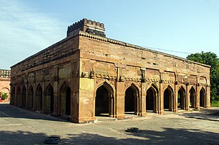
Chunar is a city located in Mirzapur district of Indian state of Uttar Pradesh. It is nearby Mirzapur city. The railway tracks passing through Chunar Junction railway station leads to major destinations of India, including Howrah, Delhi, Tatanagar and Varanasi. National Highway 35 also passes through Chunar. It is connected to the city of Mirzapur and Varanasi by roads and rails. Chunar is well known for its handicraft products made from clay and plaster of paris. It is also famous for its historical place - Chunar Fort.

Mirzapur district is one of the 75 districts in the Indian state of Uttar Pradesh. The district is bounded on the north by Bhadohi and Varanasi districts, on the east by Chandauli district, on the south by Sonbhadra district and on the northwest by Prayagraj. The district occupies an area of 4521 km2. Mirzapur city is the district headquarters. Mirzapur district is a part of Mirzapur division. This district is known for the Vindhyavasini temple in Vindhyachal and several tourist attractions like waterfalls like Rajdari and Devdari and dams. It consist of several Ghats where historical sculptures are still present. During the Ganges festival these Ghats are decorated with lights and earthen lamps.

Farrukhabad district is a district of Uttar Pradesh state of India. The town of Fatehgarh is the district headquarters. The district is part of Kanpur Division.
Cuncolim is a town in South Goa district in the state of Goa, India.

Robertsganj also known as Sonbhadra City is a city and a municipal board in Sonbhadra district in the Indian state of Uttar Pradesh.

Banaras State initially known as Banaras kingdom or Kashi Kingdom was a kingdom and later princely state under the Narayan Dynasty in what is today Uttar Pradesh, India. On 15 October 1948, Benares' last ruler signed the accession to the Indian Union.
In Hindu tradition, Triveni Sangam is the confluence of three rivers that is also a sacred place, with a bath here said to flush away all of one's sins and free one from the cycle of rebirth.

Situated in the northern part of India, bordering with the capital of India New Delhi, Uttar Pradesh is one of the most popular and an established tourist destination for both Indians and non-Indians alike in India. The most populous state of India, Uttar Pradesh contains many historical monuments and places of religious significance. Geographically, Uttar Pradesh is very diverse, with Himalayan foothills in the extreme north and the Gangetic Plain in the centre. It is also home of India's most visited sites, Hinduism's holiest city, Varanasi. Kumbh city, Prayagraj. Kathak, one of the eight forms of Indian classical dances, originated from Uttar Pradesh. Uttar Pradesh is at the heart of India, hence it is also known as The Heartland of India. Cuisine of Uttar Pradesh like Awadhi cuisine, Mughlai cuisine and Bhojpuri cuisine are very famous not only in India but also many places abroad.

Yana is a tourist destination located in forest of Katgal Range, which is also a part of Malenadu region of Uttara Kannada district of Karnataka state in India. Yana is one of the wettest villages in the world. It is the cleanest village in Karnataka and the second cleanest village in India. The two unique rock outcrops after the village are tourist attractions and easily approachable by two routes one from Kumta-Sirsi Highway by a small trek through 0.5 kilometres (0.31 mi) the thick forests from the nearest road head and another from Sirsi-Ankola Road.
The Sapta Puri are a group of seven Hindu tirtha, or holy pilgrimage sites, located in India. Pilgrimage to these sites is said to bless the pilgrim with moksha.

Tourism in India is economically important and ever-growing. The World Travel & Tourism Council calculated that tourism generated ₹14.02 lakh crore (US$170 billion) or 9.6% of the nation's GDP in 2016 and supported 40.343 million jobs, 9.3% of its total employment. The sector is predicted to grow at an annual rate of 6.8% to ₹28.49 lakh crore (US$340 billion) by 2027.

Sattari is a village in Malda district of the state of West Bengal, India. Sattari is known for producing mango (aam) supply, lace (gamchha), and carpet work. It is the headquarters of Binodpur Gram Panchayat on which it is represented by 6 of the 13 seats.
Mangar Bani, a paleolithic archaeological site and sacred grove hill forest next to the Mangar village on Delhi-Haryana border; is in the South Delhi Ridge of Aravalli mountain range in Faridabad tehsil of Faridabad district in the Indian state of Haryana. It lies, immediate south of India's national capital Delhi, within NCR.