Khreshchatyk

Last updated • 8 min readFrom Wikipedia, The Free Encyclopedia

Khreshchatyk
Хрещатик
Khreshchatyk.jpg
Khreshchatyk in 2021
Former name(s)Wacław Worowski Street (1923–1937), Eichhornstraße (1941–1943)
Length1.2 km (0.75 mi)
Location Kyiv, Ukraine
Nearest metro station Maidan Nezalezhnosti / Khreschchatyk ( Kyiv Metro Line 2.svg / Kyiv Metro Line 1.svg )
Teatralna / Zoloti Vorota ( Kyiv Metro Line 1.svg / Kyiv Metro Line 3.svg )
From European Square
Major
junctions
Maidan Nezalezhnosti
To Bessarabska Square
Other
Statuspedestrianised during weekends and public holidays
Official nameВулиця Хрещатик
TypeUrban Planning
Reference no.927-Кв

Khreshchatyk (Ukrainian : Хрещатик, pronounced [xreˈʃt͡ʃɑtɪk] ) is the main street of Kyiv, the capital city of Ukraine. The street is 1.2 kilometres (0.75 mi) long, and runs in a northeast-southwest direction from European Square through the Maidan to Bessarabska Square and the Besarabsky Market. The offices of the Kyiv City Council, the Post Office, the Ministry of Agrarian Policy and Food, the State Committee of Television and Radio Broadcasting, the TsUM department store, and the Ukrainian House, are all located on Khreshchatyk.

Contents

Khreshchatyk was deliberately destroyed during World War II by retreating Red Army troops. Among the notable buildings that were dynamited were the Kyiv City Duma, the Kyiv Stock Exchange, the National Hotel  [ uk ], and the Ginsburg Skyscraper. The street was rebuilt in a Stalinist neo-classical style after the end of the war, and has been renovated since Ukraine's independence.

History

Origins

The area of Kyiv now occupied by Khreshchatyk was originally a forest-covered valley with a stream flowing through it. In ancient times, it was a hunting place where Kyiv residents hung out nets to catch wild animals,which gave the ancient name of the area, Perevesishte. The name Khreshchatyk is believed to be derived from the Slavic word krest or khrest (cross), as it lies in a valley that is crossed by several ravines. [1] A small river, the Khreshchatyk River, a tributary of the Lybid River, ran along much of the valley. [2] A road ran beside the stream. [1]

A 1780s map of Kyiv 1780s map of Kyiv.jpg
A 1780s map of Kyiv

In 1770, the doctor and diarist John Lerche described the landscape: "At the end of the Pechersk suburb, there is a narrow road (Khreshchatytskaya) due to a deep gulley or valley; but it cannot be avoided, because it connects all three cities." [3]

In Kievan Rus' times, the fortifications of the Upper Town existed across Old Kyiv Hill  [ uk ] above the ravine. These had been reduced to ruins by the early 19th century, when they were removed, leaving a square at the foot the hill at the modern Maidan Nezalezhnosti. [4] Construction of the street started at the end of the 18th century, when the ravine began to be filled in. The first houses, built in 1797, were wooden, with the earliest recorded building being the late 18th-century mansion of a landowner called Golovinsky. [1] [5]

19th century - World War I

In 1804–1806, the first theatre in Kyiv was built at one end of the street. It was a wooden structure that was later demolished and replaced by the three-storey European Hotel  [ uk ]. [1]

Kyiv Central Post Office in the 1900s Poshta Khreshchatik 1900.jpg
Kyiv Central Post Office in the 1900s

Khreshchatyk began to be developed in the 1830s and 1840s, beginning from the European Square end. Its current design emerged in 1837 when it was planned as Kyiv's principal street by architects that included the city architect, Ludvik Stanzani  [ uk ]. [6] From 1868 banks started to be located on Khreshchatyk. The Kyiv Stock Exchange was built in 1869. The thoroughfare became one of the most famous in the Russian Empire. [7] The new City Hall  [ uk ] was built on the street in 1874–1876. Other notable buildings constructed during this period were the Merchants' Hall, the concert hall, the Central Post Office, and the Club for Polish Noblemen. During the 1880s, its wooden-built restaurants and taverns were being replaced by stone-built multi-storey houses and shops. The street, with its departmental stores and hotels, was called "the only real street in Kiev," and, along with the city’s larger churches, became its central modern attraction for visitors. [5]

The Brotherhood of Saints Cyril and Methodius met at the apartment of 19th-century Ukrainian historian Mykola Kostomarov on Khreshchatyk. [5]

The street was lit by gas in 1872, and by electricity in the 1890s. In 1897 it was still the only street in the city with electric lights. [5] Horse-drawn trams had first appeared in the city in 1869, and steam-powered trams a few years later; but the terrain was too hilly for them, and they sometimes ran out of control downhill. [5] In 1892, the first electric tram line in the empire ran in Kyiv, and the Russian Empire's first electric tram was extended from Khreshchatyk to Podol. In 1904, the pavement was laid with granite cobbles, [8] having been first provided with a hard surface in 1888, [5]

The demonstration on Khreshchatyk, March 1917 The demonstration on Khreshchatyk, March 1917.jpg
The demonstration on Khreshchatyk, March 1917

Revolutionary rallies and demonstrations took place on the street in 1901, 1902, 1905, and in June 1917. [8]

Pre-World War II Soviet Ukraine

During the period of chaos after the Russian Revolution of 1917, the Ukrainian, German, Polish, and Russian Bolshevik forces all controlled Kyiv at various times. [9] On 9 May 1920, the Polish army under General Rydz-Smigly celebrated their capture of Kyiv by a victory parade on Khreshchatyk. [10] They were driven out by the Russian Bolshevik counter-offensive within weeks. [9]

After the establishment of the Soviet authorities, Khreshchatyk became a place where celebrations, labour demonstrations, and military parades took place. [8]

Between the wars, Khreshchatyk underwent major development and reconstruction. [8] Between 1923 and 1937, it was renamed Vorovsky Street, after Vatslav Vorovsky, an early Bolshevik diplomat who had been assassinated in Switzerland. [11] In 19341935 the street was re-paved, the tram line was removed and a trolleybus service began. [8]

World War II

The remains of part of the street following its destruction in September 1941 A Hrescsatik sugarut felrobbantott epuletei, jobbra a Gyetszkij Mir (Gyermekvilag) aruhaz romjai. Fortepan 14033.jpg
The remains of part of the street following its destruction in September 1941

During World War II, almost every building on Khreshchatyk was laid with explosives by the retreating Red Army troops. On 24 September 1941, five days after German troops had occupied the city, [12] radio-controlled explosions were set off from over 400 kilometres (250 mi) away. The demolition of Khreshchatyk became the first operation in history where the long-distance radio-controlled explosions were used for military purposes. This unprecedented method of warfare caused panic and brought heavy casualties among both the occupiers and city's remaining civilian population.[ citation needed ]

Under German occupation, the street was renamed Eichhornstrasse, after Hermann von Eichhorn, a field marshal and the supreme commander of Army Group Kyiv and simultaneously military governor of Ukraine during the previous German occupation, who in 1918 had been assassinated on Khreshchatyk by the social revolutionary Boris Donskoy. [13]

Post-war Soviet Ukraine

Khreshchatyk during the 1980s Kreschatik classic.jpg
Khreshchatyk during the 1980s

In 1944, the Soviet authorities planned to enlarge Khreschatyk when it was rebuilt. After the end of the war, 30 damaged buildings that could have been restored were demolished. [14] The thoroughfare was rebuilt in the 1950s and 1960s. It was widened to become 75–100 metres (246–328 ft) wide, and new buildings were erected in the Neoclassical Stalinist architectural style. [8] Important buildings of the new ensemble include the headquarters of Kyiv City Council (Kyivrada), the Central Post Office (Poshtamt) and Trade Unions Building (Budynok Profspilok).[ citation needed ] The picturesque quality of Khreshchatyk was enhanced by the street being replanted with chestnut trees. [8]

The street was used for demonstrations and parades in honour of 1 May (until 1969), Victory Day (9 May) and the October Revolution.

The street was one of the first parts of the city to be serviced by the Kyiv Metro, when the Khreshchatyk station was opened in 1960, and became the system's first transfer station upon the opening of a second line in 1976.

A few days after the Chernobyl nuclear accident, the Soviet authorities held the 1986 May Day parade on Khreshchatyk  [ uk ], to "calm people" and "prevent panic" caused by the disaster. Thousands of Kyivans, including many children, were exposed to dangerous doses of radiation as a result.

In 1989, part of the Kyiv Central Post Office building collapsed  [ uk ] during heavy rain, killing a dozen people and injuring others. [15]

Post-independence

Imperial, Stalinist and modern buildings on Khreshchatyk Chrescatyk.jpg
Imperial, Stalinist and modern buildings on Khreshchatyk

On 24 July 1990, the first ceremonial raising of the Ukrainian national flag took place on Khreshchatyk, at the Kyiv City Council building. [16] In 2010, Khreshchatyk was listed as one of Europe's most expensive streets for renting commercial space. [17] The Kyiv Independence Day Parades, passing through Khreshchatyk, have been held since 1994. [18]

In 2000/2001, Khreshchatyk and Maidan Nezalezhnosti became the centre of the mass protest campaign Ukraine without Kuchma. To keep the protesters out, the city mayor Oleksandr Omelchenko ordered the area to be fenced off as a construction site. [19] In the winter of 2004, Khreshchatyk and Maidan Nezalezhnosti became the centre of the main public protests of the Orange Revolution. The protesters' main tent encampment was situated in the street. At its peak, over a million people from all around Ukraine attended the rally. [20] [21] In late 2013, Khreshchatyk became one of the centres of the Revolution of Dignity. [22]

Following the 2022 Russian invasion of Ukraine, the annual Kyiv parade was cancelled, and in its place there was a display of the burnt remains of Russian military vehicles. [23] It was reported that Russian forces were expecting to parade down Khreshchatyk within three days of the start of the invasion, and that some soldiers had been issued ceremonial uniforms for that purpose. [24]

Kyiv City Council, Kyiv City State Administration, the Ministry of Agrarian Policy and Food, the State Committee for Television and Radio-broadcasting, and a number of cinemas and hotels, are all located on the street. [25]

Attractions

TSUM Kyiv TsUM Kyiv.jpg
TSUM Kyiv

Khreshchatyk is a popular attraction for visitors to the city and residents. During weekends, the street is closed to road traffic. [26] It is a traditional setting for outdoor concerts and festivals, and is frequented by street musicians. [27]

Points of interest include the 19th-century Besarabsky indoor Market, the shops, offices and PinchukArtCentre in the Besarabsky Quarter, the Metrohrad underground shopping centre, TSUM Kyiv, Kyiv Passage (a small narrow commercial and residential street), and the City Council building.

Major parades and celebrations are held on Kyiv Day (the last Sunday of May), Victory Day (9 May), and Independence Day (24 August).

Transportation

Four of the stations of the Kyiv Metro, the city's rapid transit system, serve the street. Passengers are able to transfer by foot from Maidan Nezalezhnosti to Khreshchatyk, as well as from Teatralna to Zoloti Vorota. [28] [29]

Related Research Articles

<span class="mw-page-title-main">Kyiv</span> Capital of Ukraine

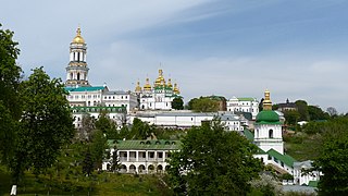
Kyiv is the capital and most populous city of Ukraine. It is in north-central Ukraine along the Dnieper River. As of 1 January 2022, its population was 2,952,301, making Kyiv the seventh-most populous city in Europe. Kyiv is an important industrial, scientific, educational, and cultural center in Eastern Europe. It is home to many high-tech industries, higher education institutions, and historical landmarks. The city has an extensive system of public transport and infrastructure, including the Kyiv Metro.

<span class="mw-page-title-main">Maidan Nezalezhnosti</span> Central Square in Kyiv, Ukraine

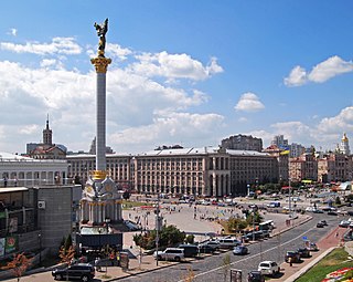
Maidan Nezalezhnosti (Ukrainian: Майдан Незалежності, IPA:[mɐjˈdɑnnezɐˈɫɛʒnosti] or Independence Square is the central town square of Kyiv, the capital city of Ukraine. One of the city's main squares, it is located on Khreshchatyk Street in the Shevchenko Raion. The square contains the iconic Independence Monument.

<span class="mw-page-title-main">Hotel Ukraine</span>

Hotel Ukraine, also referred to as Hotel Ukraina or Hotel Ukrayina, is a four-star hotel located in central Kyiv, the capital of Ukraine. It was built in 1961 as the Hotel "Moscow" in a location which originally was occupied by Kyiv's first skyscraper, the Ginzburg House. The construction of the hotel finished the architectural ensemble of Kyiv's main street – the Khreshchatyk – which formed the post-war reconstruction of central Kyiv. The hotel is state-owned and belongs to the State Management of Affairs.

<span class="mw-page-title-main">Khreshchatyk (Kyiv Metro)</span> Kyiv Metro Station

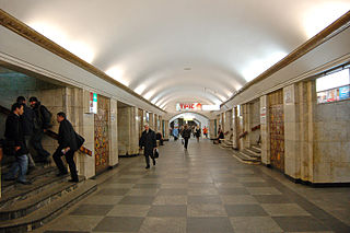
Khreshchatyk is a station on the Sviatoshynsko-Brovarska Line of the Kyiv Metro. The station is named for the Khreshchatyk street, the most central street in Kyiv. The station was opened in 1960 along with the first stage of the Metro. It The station is pylon trivault that features ceramic Ukrainian ornaments framed by metallic grills on the central hall sides of the pylons. White marble is used elsewhere, particularly for the walls and the main pylon frames. The ceiling is covered in white plaster and lighting comes from hidden lamps in the niches of the central vault and a central row of lamps.

<span class="mw-page-title-main">Maidan Nezalezhnosti (Kyiv Metro)</span> Kyiv Metro Station

Maidan Nezalezhnosti is a station on Kyiv Metro's Obolonsko–Teremkivska line. The station was opened on 17 December 1976, and is named after Kyiv's Maidan Nezalezhnosti on the Khreshchatyk street. It was designed by N. Kolomiiets, I. Maslenkov, M. Syrkyn, and F. Zaremba.

<span class="mw-page-title-main">Ukrainian House</span> Convention center in Kyiv, Ukraine

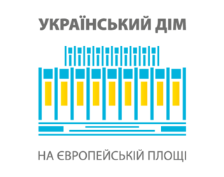
The Ukrainian House International Convention Center, is the largest international exhibition and convention center in Kyiv, Ukraine. The five-storey building is the host venue for a variety of events from exhibitions, trade fairs and conferences to international association meetings, product launches, banquets, TV-ceremonies, sporting events, etc.

<span class="mw-page-title-main">Kyiv City Duma building</span> Destroyed building in Kyiv, Ukraine

The Kyiv City Duma building housed the Kyiv City Duma before World War II. The building was located on the then Dumskaya Ploschad of the Khreschatyk street in Kyiv and stood in the centre of it.

<span class="mw-page-title-main">Prorizna Street</span>

Prorizna Street is a street located in central Kyiv, Ukraine.

<span class="mw-page-title-main">Bessarabska Square</span> Square in Kyiv, Ukraine

The Bessarabska Square is a square located at the southwest end of Khreshchatyk, the main thoroughfare of Kyiv, the capital of Ukraine. It is located in the city's Shevchenkivskyi District (district), at the busy intersection of Khreshchatyk, Taras Shevchenko Boulevard, Velyka Vasylkivska Street, and the Krutyi Descent streets.

<span class="mw-page-title-main">Euromaidan</span> 2013–14 protests in Ukraine

Euromaidan, or the Maidan Uprising, was a wave of demonstrations and civil unrest in Ukraine, which began on 21 November 2013 with large protests in Maidan Nezalezhnosti in Kyiv. The protests were sparked by President Viktor Yanukovych's sudden decision not to sign the European Union–Ukraine Association Agreement, instead choosing closer ties to Russia and the Eurasian Economic Union. Ukraine's parliament had overwhelmingly approved of finalizing the Agreement with the EU, but Russia had put pressure on Ukraine to reject it. The scope of the protests widened, with calls for the resignation of Yanukovych and the Azarov government. Protesters opposed what they saw as widespread government corruption, abuse of power, human rights violations, and the influence of oligarchs. Transparency International named Yanukovych as the top example of corruption in the world. The violent dispersal of protesters on 30 November caused further anger. Euromaidan was the largest democratic mass movement in Europe since 1989 and led to the 2014 Revolution of Dignity.

Below are the domestic responses to the Euromaidan. Euromaidan was a wave of demonstrations and civil unrest in Ukraine that began on the night of 21 November 2013 after the Ukrainian government suspended preparations for signing an Association Agreement and Deep and Comprehensive Free Trade Agreement with the European Union.

<span class="mw-page-title-main">Trade Unions Building (Kyiv)</span> Office building in Kyiv, Ukraine

The Trade Unions Building, or Budynok Profspilok, is a large office building in Kyiv, Ukraine. Located on the city's main Khreshchatyk Street, its façade faces the central Maidan Nezalezhnosti square and contains the city's main clock tower.

In response to a police crackdown on Euromaidan's protesters in the early hours of 30 November, more than half a million Kyivans joined the protests on 1 December in order to defend the students "and to protect society in the face of crippling authoritarianism."

<span class="mw-page-title-main">Timeline of the Euromaidan</span>

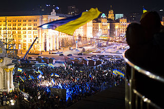
Euromaidan was a wave of demonstrations and civil unrest in Ukraine, which began on the night of 21 November 2013 with large public protests demanding closer European integration. Protesters also stated they joined because of the dispersal of protesters on 30 November and "a will to change life in Ukraine". The scope of the protests evolved over subsequent months, and by 25 January 2014 the protests were fueled by the perception of widespread government corruption, abuse of power, and violation of human rights in Ukraine. By February 2014 the protests had largely escalated into violence, resulting in the Revolution of Dignity and the resignation of Azarov's government and ousting of President Yanukovych. This resulted in the outbreak of the Russo-Ukrainian War.

<span class="mw-page-title-main">Race Horizon Park</span> Ukrainian one-day road cycling races

Race Horizon Park is an international cycling road race, held annually in the capital of Ukraine, during the celebration of the Day of Kyiv. As a part of the bicycle race, a traditional parade of amateur cyclists is held as well – Bicycle Day.

<span class="mw-page-title-main">Hotel Dnipro</span> Hotel in Kyiv, Ukraine

Hotel Dnipro is a four-star hotel located in central Kyiv, the capital of Ukraine, on European Square, next to Khreschatyk Street and near Maidan Nezalezhnosti.

The Metrohrad is an extensive underground shopping mall at Bessarabska Square, Kyiv, Ukraine.

<span class="mw-page-title-main">2010 Kyiv Victory Day Parade</span> Anniversary event

The 2010 Kyiv Victory Day Parade was held on May 9, 2010, in Kyiv, honoring the 65th anniversary of the Soviet Union's victory in the Great Patriotic War. Military vehicles and soldiers dressed in Soviet Army uniforms marched on Khreschatyk Street and through Maidan Nezalezhnosti. Inspecting the parade was the Chief of the General Staff of the Armed Forces General of the Army Ivan Svyda while the commander of the Ukrainian Ground Forces, Colonel General Henadii Vorobiov commanded the parade. The decree for holding the parade was signed on 23 March of that year. The President of Ukraine Viktor Yanukovych delivered a jubilee address in his position as Supreme Commander. 2,500 members of the Ukrainian Armed Forces as well as troops from Russia and Belarus took part in the parade. 17 military bands took part in the parade under the command of the Chief of the Military Music Department of the General Staff of the Ukrainian Armed Forces, Major General Volodymyr Derkach.

<span class="mw-page-title-main">60th Anniversary of the Liberation of Ukraine</span>

The 60th Anniversary of the Liberation of Ukraine was a celebration in Kyiv, Ukraine on October 27–28, 2004 on the occasion of the 60th anniversary of the liberation of Ukraine from the Nazi Invaders. It was notable in that it was timed to the 2004 Ukrainian presidential election that occurred a week later. It was the first time the anniversary was celebrated since independence.

<span class="mw-page-title-main">70th Anniversary of the Liberation of Kyiv</span>

The 70th Anniversary of the Liberation of Kyiv was a celebration in Kyiv, Ukraine, on November 6, 2013, on the occasion of the 70th anniversary of the liberation of Kyiv from the Nazi Invaders.

References

  1. 1 2 3 4 Dobrovolsky 1981, p. 831.
  2. "Khreshchatyk". Old Kyiv. Archived from the original on 22 April 2022.
  3. Semenova 1897, p. 259.
  4. Oliynyk 2018, pp. 2–3.
  5. 1 2 3 4 5 6 Hamm 1993, p. 32.
  6. Oliynyk 2018, p. 3.
  7. Hamm 1993, p. 29.
  8. 1 2 3 4 5 6 7 Dobrovolsky 1981, p. 832.
  9. 1 2 Zhukovsky, Arkadii. "Ukrainian-Soviet War, 1917–21". Internet Encyclopaedia of Ukraine. Canadian Institute of Ukrainian Studies. Retrieved 21 September 2023.
  10. Rukkas, Andriy (9 May 2020). "Victory parade of Poles and Ukrainians on Khreschatyk: how it was on May 9, 1920". BBC. Archived from the original on 18 July 2020. Retrieved 21 September 2023.
  11. Krutikov 2019, p. 83.
  12. Stefanoviс, Dmitry. "Unknown Khreschatyk, or why wait until tomorrow?". National Technical University of Ukraine “Igor Sikorsky Kyiv Polytechnic Institute”. Retrieved 20 September 2023.
  13. "Зеркало Века" [Mirror of the Century]. Zerkalo Nedeli . Vol. 98, no. 23. 13 July 1996. Archived from the original on 12 May 2005. Retrieved 20 September 2023.
  14. Shirochyn, Semyon (8 April 2022). "Post-war Khreschatyk: Price is the question". Pragmatika. Retrieved 21 September 2023.
  15. "Eleven killed in post office collapse in Kiev". UPI. 3 August 1989. Archived from the original on 11 December 2022. Retrieved 22 September 2023.{{cite news}}: CS1 maint: bot: original URL status unknown (link)
  16. Kubijovyč, Volodymyr; Pavlovsky, Vadym; Stebelsky, Ihor; Zhukovsky, Arkadii. "Kyiv". Internet Encyclopaedia of Ukraine. Canadian Institute of Ukrainian Studies. Retrieved 22 September 2023.
  17. "Khreshchatyk rated among Europe's top 20 most expensive streets". Kyiv Weekly. Archived from the original on 16 December 2013. Retrieved 2 April 2012.
  18. "A consolideted unit of the Army Academy is taken part in the preparations for Independence Day in Kyiv". Hetman Petro Sahaidachnyi National Army Academy. Retrieved 9 September 2017.
  19. Bailey, Lydia (9 February 2013). "Ukrainians protest for regime change (Ukraine Without Kuchma), 2000-2003". Global Nonviolent Action Database. Retrieved 22 September 2023.
  20. Miller, William Green (18 January 2005). "The Orange Revolution and the Maidan Parliament". Wilson Center . Retrieved 22 September 2023.
  21. Demes & Forbrig 2006, p. 96.
  22. Chausovsky, Eugene (1 July 2020). "U.S. Protests and Lessons from Ukraine's EuroMaidan". New Lines Institute . Retrieved 22 September 2023.
  23. Peterson, Nolan (22 August 2022). "Kyiv readies for Ukrainian Independence Day with display of ruined Russian tanks". Coffee or Die Magazine. Retrieved 25 August 2022.
  24. Sabbagh, Dan; Koshiw, Isobel (28 December 2022). "The battle for Kyiv revisited: the litany of mistakes that cost Russia a quick win". The Guardian . Retrieved 28 December 2022.
  25. Zhukovsky, Arkadii. "Khreshchatyk". Internet Encyclopaedia of Ukraine. Canadian Institute of Ukrainian Studies. Retrieved 22 September 2023.
  26. Hansen 2021, p. 141.
  27. Chausovsky, Eugene (3 November 2016). "Ukraine: Young Entrepreneurs Taking Matters into Their Own Hands". Eurasianet . Retrieved 22 September 2023.
  28. "Станція "Майдан Незалежності"" [Maidan Nezalezhnosti station] (in Ukrainian). Kyiv Metro. Archived from the original on 13 March 2007. Retrieved 22 September 2023.
  29. "Станція "Площа Л. Толстого"" [L. Tolstoy Square station] (in Ukrainian). Kyiv Metro. Archived from the original on 13 March 2007. Retrieved 22 September 2023.

Sources

Further reading

50°26′50″N30°31′19″E / 50.44722°N 30.52194°E / 50.44722; 30.52194