Kilburn, Derbyshire

Last updated

Kilburn
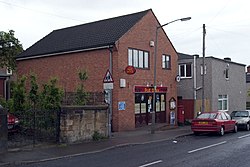
Kilburn PO 013619 2a5bd0b5.jpg
Kilburn Post Office, in 2005
Derbyshire UK location map.svg
Red pog.svg
Kilburn
Location within Derbyshire
Population3,618 (2011)
OS grid reference SK385455
District
Shire county
Region
Country England
Sovereign state United Kingdom
Post town BELPER
Postcode district DE56
Dialling code 01332
Police Derbyshire
Fire Derbyshire
Ambulance East Midlands
UK Parliament
List of places
UK
England
Derbyshire
53°00′20″N1°25′32″W / 53.005567°N 1.425441°W / 53.005567; -1.425441 Coordinates: 53°00′20″N1°25′32″W / 53.005567°N 1.425441°W / 53.005567; -1.425441

Kilburn is a village and civil parish in the English county of Derbyshire, known as Kilbourne until around 100 years ago. The population of the civil parish taken at the 2011 Census was 3,618. [1]

Contents

Forming part of the borough of Amber Valley, Kilburn has few amenities for the people who live there including a local police station, community officer and several parks for young children. There is a Chinese restaurant, Jade Garden. The local fish and chip shop, Kilburn Fish Bar, closed in April 2021. There is a shop in the village, Metro Stores. The village post office is inside of Metro. There are two hair and beauty salons in Kilburn, Amber Hair and Vanity. It was historically served by Kilburn railway station on the Midland Railway Ripley Branch.

The Hunters Arms Kilburn - The Hunters Arms.jpg
The Hunters Arms

Kilburn used to have two public houses: The Hunters Arms and the Travellers Rest. Only the Hunters Arm remains open. There is also a working men's club (Kilburn Social Club) adjoined to the football field at the back of Chapel Street. The other prominent features of the village include the War Memorial situated at the top of Bywell Lane, and the Village Hall on Church St, which hosts various leisure activities and is available for residents to hire and use via their Facebook page.
Kilburn is served by three schools within the village: Kilburn Nursery (4 - 5), Kilburn Infant School (5 - 7) and Kilburn Junior School (7 - 11). School children then progress to John Flamsteed Community School in Denby [2] until they are 16.

Baptist Church Kilburn - Baptist Church.jpg
Baptist Church

There is also a Baptist Chapel as well as a Methodist Chapel, located on Highfield Road and Chapel St, respectively.

A number of associations serve the village. The Parish Council is elected from local residents and works toward improving and maintaining the village. The Kilburn Community Association voluntarily maintain and operate the Kilburn Village Hall. A village newsletter, locally circulated, report on the work of these bodies, as well as other institutions such as the local Women's Institute which serves both Kilburn and Denby. There are annual traditions such as a village treasure hunt, a village quiz, the junior school Summer Fair and Christmas Shopping Evening and carol singing which raise funds both for the village and charitable causes in Derbyshire.

See also

Related Research Articles

Ripley, Derbyshire Town in Amber Valley district, Derbyshire, England

Ripley is a town in the Amber Valley borough of Derbyshire, England. Engineers from Ripley came up with some early improvements to the railway system.

Amber Valley Local government district and borough in England

Amber Valley is a local government district and borough in the east of Derbyshire, England, taking its name from the River Amber. It covers a semi-rural zone with four main towns whose economy was based on coal mining and remains to some extent influenced by engineering, distribution and manufacturing, holding for instance the headquarters and production site of Thorntons confectionery.

Belper Town and civil parish in Amber Valley, Derbyshire, England

Belper is a town and civil parish in the local government district of Amber Valley in Derbyshire, England, located about 7 miles (11 km) north of Derby on the River Derwent. As well as Belper itself, the parish also includes the village of Milford and the hamlets of Bargate, Blackbrook and Makeney. As of the 2011 Census, the parish had a population of 21,823. Originally a centre for the nail-making industry since Medieval times, Belper expanded during the early Industrial Revolution to become one of the first mill towns with the establishment of several textile mills; as such, it forms part of the Derwent Valley Mills World Heritage Site.

Heanor Town in Derbyshire, England

Heanor (/ˈhiːnə/) is a town in the Amber Valley district of Derbyshire in the East Midlands of England. It lies 8 miles (13 km) north-east of Derby and forms, with the adjacent village of Loscoe, the civil parish and town council-administered area of Heanor and Loscoe, which had a population of 17,251 in the 2011 census.

West Hallam Human settlement in England

West Hallam is a large village and civil parish close to Ilkeston in the county of Derbyshire in the East Midlands region of England. West Hallam has had its own parish council since 1894 and, since 1974, has been part of the Erewash borough. The population of the civil parish was 4,829 at the 2001 census reducing to 4,686 at the 2011 census.

Bembridge Human settlement in England

Bembridge is a village and civil parish located on the easternmost point of the Isle of Wight. It had a population of 3,848 according to the 2001 census of the United Kingdom, leading to the implausible claim by some residents that Bembridge is the largest village in England. Bembridge is home to many of the Island's wealthiest residents. The population had reduced to 3,688 at the 2011 Census.

Clay Cross Human settlement in England

Clay Cross is a town and a civil parish in the North East Derbyshire district of Derbyshire, England. It is a former industrial and mining town, about 5 miles (8.0 km) south of Chesterfield. It is directly on the A61. Surrounding settlements include North Wingfield, Tupton, Pilsley and Ashover.

Chinley Human settlement in England

Chinley is a rural village in the High Peak Borough of Derbyshire, England, with a population of 2,796 at the 2011 Census. Most of the civil parish is within the Peak District National Park. Historically, before the coming of the railway, the area was economically dominated by agriculture. Nowadays most inhabitants commute out of the village to work; accessible centres of work include Stockport, Sheffield and Manchester.

Hampstead Norreys Human settlement in England

Hampstead Norreys is a village and civil parish in Berkshire, England. It is centred on the small tributary the River Pang, north of Newbury.

Melbourne, Derbyshire Human settlement in England

Melbourne is a market town and civil parish in South Derbyshire, England. It was home to Thomas Cook, and has a street named after him. It is 8 miles (13 km) south of Derby and 2 miles (3 km) from the River Trent. The population of the civil parish at the 2011 Census was 4,843.

Hayfield, Derbyshire Human settlement in England

Hayfield is a village and civil parish in High Peak, Derbyshire, England, with a population of around 2,700. The village is 3 miles (4.8 km) east of New Mills, 4.5 miles (7.2 km) south of Glossop and 10 miles (16 km) north of Buxton, in the basin of the River Sett.

Hasland Human settlement in England

Hasland is a suburb in the Borough of Chesterfield in the town of Chesterfield, Derbyshire, England. Hasland is located south of Spital, east of Birdholme and north of Grassmoor. Hasland is a ward of the Borough of Chesterfield. The ward population at the 2011 Census was 6,969. The A617 links Hasland, along with Chesterfield, to the M1.

Queensbury, West Yorkshire Village in West Yorkshire, England

Queensbury is a large village in the metropolitan borough of Bradford, West Yorkshire, England. Perched on a high vantage point above Halifax, Clayton and Thornton and overlooking Bradford itself, Queensbury is one of the highest parishes in England, with fine views beyond the West Yorkshire conurbation to the hills of Brontë Country and the Yorkshire Dales to the north and north west. It had a population of 8,718 in 2001 which increased to 16,273 in the 2011 Census.

Denby Dale Village and civil parish in West Yorkshire, England

Denby Dale is a village and civil parish in the metropolitan borough of Kirklees in West Yorkshire, England. It is 10 miles to the south-east of Huddersfield and 9 miles north-west of Barnsley.

Shap Village and civil parish in Cumbria, England

Shap is a linear village and civil parish located among fells and isolated dales in Eden district, Cumbria, England, in the historic county of Westmorland. The parish had a population of 1,221 in 2001, increasing slightly to 1,264 at the 2011 Census.

Codnor Human settlement in England

Codnor is a Derbyshire village and civil parish in the Amber Valley district, and a former mining community, with a population of 3,766 as taken at the 2011 Census. It is approximately 12 miles from the city of Derby and 14 miles from Nottingham by road.

Tibshelf Human settlement in England

Tibshelf is a village and civil parish in the Bolsover District in Derbyshire, England. Located between the towns of Clay Cross, Shirebrook, Mansfield and Chesterfield. It had a population at the 2001 UK census of 3,548, increasing to 3,787 at the 2011 Census. Tibshelf shares its boundaries with the villages of Morton, Pilsley, Newton, Teversal and Hardstoft.

Tupton Human settlement in England

Tupton is a village and civil parish in North East Derbyshire, Derbyshire, England, 4.5 miles (7 km) south of Chesterfield. The population of the civil parish including Egstow and Old Tupton was at the 2011 Census 3,428. It lies just north of Clay Cross on the A61 which runs from Chesterfield to Alfreton. It comprises the areas of Old Tupton and New Tupton. However, it is generally referred to as Tupton. A similarly named area, Tapton, is a few miles away, being part of Chesterfield.

Brimington Human settlement in England

Brimington is a large village and civil parish in the Borough of Chesterfield in Derbyshire, England. The population of the parish taken at the 2011 census was 8,788. The town of Staveley is to the east, and Hollingwood is nearby. The parish includes Brimington Common along the Calow Road, and New Brimington, a late 19th-century extension towards the Staveley Iron Works.

Clifton is a village in the Derbyshire Dales district of Derbyshire, England. The village is situated about 1.2 miles (2 km) south west of Ashbourne, and is close to the border with Staffordshire. The appropriate civil parish is called Clifton and Compton. The population of this civil parish at the 2011 Census was 500.

References

  1. "Civil Parish population 2011". Neighbourhood Statistics. Office for National Statistics. Retrieved 17 March 2016.
  2. Kilburn Parish Council site accessed 30 April 2008