Killigarth Manor

Last updated

Killigarth Manor
Killigarth Manor (geograph 2413229).jpg
LocationClaremont Falls Road, Killigarth, Polperro, Cornwall, England
Coordinates 50°20′16″N4°30′34″W / 50.337806°N 4.509565°W / 50.337806; -4.509565
Built1872
Listed Building – Grade II
Official nameKilligarth Manor
Designated27 August 1952
Reference no. 1140790
Cornwall UK location map.svg
Red pog.svg
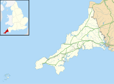
Location of Killigarth Manor in Cornwall

Killigarth Manor is a Grade II listed former manor house in the civil parish of Polperro in Cornwall, United Kingdom. It is in the hamlet of Killigarth northeast of Polperro village. It has an 1872 datestone which marks the date when the older house was demolished, though its materials were used in the building of the present house. Killigarth Manor is used as holiday accommodation. In the grounds are a holiday and caravan park. The small housing estate of Carey Park is nearby.
Contents

Manor house

An original manor house dates from 1662 and existed prior to the current one, and was described by Jonathan Couch in his History of Polperro (1871): "At the top of the eastern hill ... is the neat old manor-house of Killigarth, with its antique square-headed and granite-mullioned windows, its respectable arched doorways, and massive chimneys ... The house has on the second stage, a fine room, now used as a sleeping apartment; but, from its dimensions and the labour bestowed on its decoration, evidently once the state room of the house." [1]

In 1872, the original house was demolished and a new house was built using the same stone, as shown by the building's date stone. It is also possible that part of the house was simply remodelled, rather than fully demolished as the 1662 date stone remains. There are also record of the original building having a bell tower. The building, made of granite rubble with a slate roof, is two stories high. The present building was designated Grade II listed status on 27 August 1952. [2] Presently the grounds include a John Fowler Holiday Parks site, with some guests staying in the manor itself. [3]

Family history

Killigarth was probably owned by John de Kylgat, who is listed by Richard Carew as being among those who had estates of £20 a year in the reign of Edward I. In the reign of Henry VI it was in the possession of the Bere family from whom it passed through an heiress to the Beville family and was the seat of John Bevill, Sheriff of Cornwall in the sixteenth century. [4] Sir William Beville and his wife Frances Knyvet lived here in the reign of Queen Elizabeth I. He was the last male heir of his family who is said to have died after being gored by a bull. [5]

By 1714, the manor was owned by Revd Nicholas Kendall, the arch-deacon of Totnes. [6]

Related Research Articles

<span class="mw-page-title-main">Looe</span> Town in Cornwall, England

Looe is a coastal town and civil parish in south-east Cornwall, England, United Kingdom, with a population of 5,280 at the 2011 census.

<span class="mw-page-title-main">Princes Risborough</span> Market town in Buckinghamshire, England

Princes Risborough is a market town and civil parish in Buckinghamshire, England, about 9 miles (14 km) south of Aylesbury and 8 miles (13 km) north west of High Wycombe. It lies at the foot of the Chiltern Hills, at the north end of a gap or pass through the Chilterns, the south end of which is at West Wycombe. The A4010 road follows this route from West Wycombe through the town and then on to Aylesbury.

<span class="mw-page-title-main">Polperro</span> Human settlement in England

Polperro is a large village, civil parish, and fishing harbour within the Polperro Heritage Coastline in south Cornwall, England, United Kingdom. Its population is around 1,554.

<span class="mw-page-title-main">Merton, Oxfordshire</span> Human settlement in England

Merton is a village and civil parish near the River Ray, about 4 miles (6.4 km) south of Bicester in Oxfordshire, England. The 2011 Census recorded the parish's population as 424.

<span class="mw-page-title-main">Church End, Finchley</span> Human settlement in England

Church End is a locality within Finchley in the London Borough of Barnet in London, England. Aside from its church it centres on Finchley Central Underground station. Church End is an old village, now a suburban development, centred 7 miles (11 km) north-northwest of Charing Cross.

<span class="mw-page-title-main">Les Augrès Manor</span> Manor house

Les Augrès Manor is a manor house on La Profonde Rue in the Vingtaine de Rozel in the parish of Trinity in Jersey. The present building mostly dates from the 19th century, although the site has medieval origins. It is a listed building.

<span class="mw-page-title-main">St Mabyn</span> Human settlement in England

St Mabyn is a civil parish and village in Cornwall, England, United Kingdom. The village is situated three miles (5 km) east of Wadebridge. The parish includes a hamlet called Longstone to the east and many small manor houses, including Tregarden, Tredethy, Helligan Barton and Colquite, all built in the 16th and 17th centuries. The area of the parish is 4,101 acres (16.60 km2).

<span class="mw-page-title-main">Trerice</span> Manor House

Trerice is an historic manor in the parish of Newlyn East, near Newquay, Cornwall, United Kingdom. The surviving Tudor manor house known as Trerice House is located at Kestle Mill, three miles east of Newquay. The house with its surrounding garden has been owned by the National Trust since 1953 and is open to the public. The house is a Grade I listed building. The two stone lions on the front lawn are separately listed, Grade II. The garden features an orchard with old varieties of fruit trees.

<span class="mw-page-title-main">Talland</span> Human settlement in England

Talland is a hamlet and ecclesiastical parish and former civil parish, between Looe and Polperro, now in the parish of Polperro, in the Cornwall district, on the south coast of Cornwall, England. It consists of a church, the Old Vicarage and a few houses. In 1931 the parish had a population of 768. On 1 April 1934 the civil parish was abolished and merged with Lansallos, part also went to form Looe.

<span class="mw-page-title-main">Lewannick</span> Human settlement in England

Lewannick is a civil parish and village in Cornwall, England, United Kingdom. The village is situated approximately five miles (8 km) southwest of Launceston. The civil parish had a population of 973 at the 2011 census.

<span class="mw-page-title-main">Mawgan-in-Meneage</span> Civil parish in Cornwall, England

Mawgan-in-Meneage is a civil parish in Cornwall, England, United Kingdom. It is situated in the Meneage district of The Lizard peninsula south of Helston in the former administrative district of Kerrier. The parish population at the 2011 census was 1437.

<span class="mw-page-title-main">St Breward</span> Civil parish and village in Cornwall, England

St Breward is a civil parish and village in Cornwall, England, United Kingdom. It is on the western side of Bodmin Moor, about 6 miles (10 km) north of Bodmin. At the 2011 census the parish population including Cooksland and Fentonadle was 919.

<span class="mw-page-title-main">Withiel</span> Human settlement in England

Withiel is a civil parish and village in mid Cornwall, England, United Kingdom. The parish of Withiel is between the parishes of St Breock, Lanivet, Roche and St Wenn. The name Withiel comes from the Cornish word Gwydhyel, meaning "wooded place". The parish contains the hamlets of Withielgoose, Retire and Tregawne; the parish had a total population of about 300 in 1824.

<span class="mw-page-title-main">Whiteford House</span>

Whiteford House was an English country house near Stoke Climsland, Cornwall. It was built in 1775 by John Call and demolished in 1913.

<span class="mw-page-title-main">Menabilly</span> Estate in Cornwall, England

Menabilly is a historic estate on the south coast of Cornwall, England, situated within the parish of Tywardreath on the Gribben peninsula about 2 miles (3.2 km) west of Fowey.

<span class="mw-page-title-main">Cothelstone Manor</span>

Cothelstone Manor in Cothelstone, Somerset, England was built in the mid-16th century, largely demolished by the parliamentary troops in 1646 and rebuilt by E.J. Esdaile in 1855–56.

<span class="mw-page-title-main">Fishing in Cornwall</span> Economic activity

Fishing in Cornwall, England, UK, has traditionally been one of the main elements of the economy of the county. Pilchard fishing and processing was a thriving industry in Cornwall from around 1750 to around 1880, after which it went into an almost terminal decline. During the 20th century the varieties of fish taken became much more diverse and crustaceans such as crab and lobster are now significant. Much of the catch is exported to France due to the higher prices obtainable there. Though fishing has been significantly damaged by overfishing, the Southwest Handline Fishermen's Association has started to revive the fishing industry. As of 2007, stocks were improving. The Cornwall Sea Fisheries Committee is one of 12 committees responsible for managing the corresponding Sea Fisheries District. The Isles of Scilly Sea Fisheries Committee is responsible for the Scilly district.

Nansloe Manor, in Helston, Cornwall, England, UK, is a country house and former hotel, originally built in the 16th century.

<span class="mw-page-title-main">St Colanus' Church, Colan</span> Church

Colan Church also known as St Colan Church is a 13th-century church in Colan, mid-Cornwall, UK. Dedicated to St Colanus, it became a Grade I listed building in 1967. The vicars of St Columb Minor have served the church since the middle of the 20th century.

<span class="mw-page-title-main">Looe Bridge</span> Road bridge over the River Looe in Cornwall, England

Looe Bridge is a bridge in Looe, Cornwall, across the River Looe. Built in the 1850s to replace a dangerous 15th-century structure, the bridge carries the A387 road and is a Grade II listed building.

References

  1. Couch, Jonathan (1965) The History of Polperro. Newcastle upon Tyne: Frank Graham; p. 21
  2. "Killigarth Manor - Polperro - Cornwall - England | British Listed Buildings". www.britishlistedbuildings.co.uk. Retrieved 12 August 2016.
  3. "Killigarth Manor Holiday Park | Polperro | John Fowler". www.johnfowlerholidays.com. Retrieved 12 August 2016.
  4. "Talland". 2 December 2015.
  5. Couch (1965), p. 21
  6. Lysons, Samuel (1814). Magna Britannia: Being a Concise Topographical Account of the Several Counties of Great Britain. Containing Cornwall. Cadell. pp. 299–300.

50°20′16″N4°30′34″W / 50.337806°N 4.509565°W / 50.337806; -4.509565