Related Research Articles

Mali's transportation infrastructure is regarded as poor, even by regional standards, and deficiencies have limited economic growth and development. Nevertheless, improvements have been noted in the early 2000s. Most of the transportation in Mali consists of cars, planes, and boats.
The Niger River is the principal river of West Africa, extending about 4,180 km (2,600 mi). Its drainage basin is 2,117,700 km2 (817,600 sq mi) in area. Its source is in the Guinea Highlands in southeastern Guinea. It runs in a crescent through Mali, Niger, on the border with Benin and then through Nigeria, discharging through a massive delta, known as the Niger Delta or the Oil Rivers, into the Gulf of Guinea in the Atlantic Ocean. The Niger is the third-longest river in Africa, exceeded only by the Nile and the Congo River. Its main tributary is the Benue River.

Bamako is the capital and largest city of Mali, with a population of 1,810,366. In 2006, it was estimated to be the fastest-growing city in Africa and sixth-fastest in the world. It is located on the Niger River, near the rapids that divide the upper and middle Niger valleys in the southwestern part of the country.

The Cowlitz River is a river in the state of Washington in the United States, a tributary of the Columbia River. Its tributaries drain a large region including the slopes of Mount Rainier, Mount Adams, and Mount St. Helens.

The Bani River is the principal tributary of the Niger River in Mali. The river is formed from the confluence of the Baoulé and Bagoé rivers some 160 km (99 mi) east of Bamako and it merges with the Niger near Mopti. Its length is about 1,100 km (680 mi).

Kayes is a city in western Mali on the Sénégal River, with a population of 127,368 at the 2009 census. Kayes is the capital of the administrative region of the same name. The name "Kayes" comes from the Soninké word "karré", which describes a low humid place that floods in rainy season. The city is located 420 kilometres (260 mi) northwest of the capital Bamako.

The King Fahd Causeway is a series of bridges and causeways connecting Saudi Arabia and Bahrain. The idea of constructing the causeway was based on improving the links and bonds between Saudi Arabia and Bahrain. Surveying of the maritime began in 1968, and construction began in 1981 and continued until 1986, when it was officially opened to the public.

Lake Faguibine is a lake in Mali on the southern edge of the Sahara Desert situated 80 km west of Timbuktu and 75 km north of the Niger River to which it is connected by a system of smaller lakes and channels. In years when the height of the annual flood of the river is sufficient, water flows from the river into the lake. Since the Sahel drought of the 1970s and 1980s the lake has been mostly dry. Water has only rarely reached the lake and even when it has done so, the lake has been only partially filled with water. This has caused a partial collapse of the local ecosystem.
Markala is a commune in Mali's Ségou Region on the Niger River 35 km down stream from the town of Ségou. The commune contains 30 villages in an area of 318 square kilometers and in 2009 had a population of 45,961. Mali's primary irrigation dam, the Markala dam, lies in the commune. The main village of the commune, Diamarabougou, is on the right bank adjacent to the dam which also serves as an important road bridge.

Niono is a town and commune located in the Ségou Region of Mali. The commune has an area of approximately 491 square kilometers and includes the town and 20 of the surrounding villages. In the 2009 census it had a population of 91,554. The town is the capital of the Niono Cercle, one of seven subdivisions (cercles) of the Ségou Region. It lies on the northwest edge of the Inner Niger Delta, near the main channel of the Niger River.

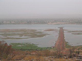
Lake Débo is a lake in the central part of Mali, formed by the seasonal flooding of the Niger River basin. It is in the Inner Niger Delta of the Niger River. During high water stages of the river, the delta formed by lakes, creeks, and backwaters form part of Lake Débo. The inner delta has many wide channels, which are shallow and flooded marshes; this delta extends over a length of 320 kilometres with a width of 80 km (50 mi). Lake Débo during high flow season, is at a distance of 80 km (50 mi) from Mopti on its upstream, on the southern end and 240 km (150 mi) from Timbuktu at its downstream, on the north-eastern end. It is the largest of many such seasonal wetlands and lakes which form the Inner Niger Delta, and the largest lake within Mali. Its size is largely reduced during the dry season of September to March. The existence of this lake called the "Great Lake" in the inner delta of Niger River between Jenne and Timbuktu in Mali has been established after extensive study of maps of the region extending over a period from 1000 to 1900 AD; 400 maps were studied for the period.

Kentucky Dam is a hydroelectric dam on the Tennessee River on the county line between Livingston and Marshall counties in the U.S. state of Kentucky. The dam is the lowermost of nine dams on the river owned and operated by the Tennessee Valley Authority, which built the dam in the late 1930s and early 1940s to improve navigation on the lower part of the river and reduce flooding on the lower Ohio and Mississippi rivers. It was a major project initiated during the New Deal of President Franklin D. Roosevelt's administration, to invest in infrastructure to benefit the country. The dam impounds the Kentucky Lake of 160,000 acres (65,000 ha), which is the largest of TVA's reservoirs and the largest artificial lake by area in the Eastern United States. It was listed on the National Register of Historic Places in 2017.

The BCEAO Tower in Bamako, Mali. At 20 stories and 80m (262ft) high, it is the tallest building in the West African nation. It sits on the north ("right→") bank of the Niger River in the center of the City of Bamako.

The Sankarani River is a tributary of the Niger River. Flowing northward from the Fouta Djallon highlands of Guinea, it crosses into southern Mali, where it joins the Niger approximately 40 kilometres (25 mi) upstream of Bamako, the capital of Mali. It forms part of the Ivory Coast-Guinea and Guinea–Mali borders.

The Palais de la culture Amadou Hampaté Ba is the national performing arts centre for Mali, located in the capitol Bamako. Founded in 1976, the PCAHB is a public establishment, supported by the state for the preservation of traditional means of artistic expression. It is directed by the Direction Nationale des Arts et de la Culture of Mali, an arm of the Ministry of Culture, and is home to a number of Malian national institutions, including the Mali Centre of the International Theatre Institute, the National Theatre, the National Orchestra, the National Ballet Company, and the National Institute of the Arts. The current Palace of Culture was constructed in 1996. It is named for the famed Malian novelist and national hero Amadou Hampaté Ba. Its current director is Madame Haïdara Aminata Sy, named March 2008.

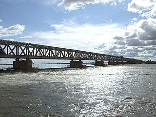
The Martyrs Bridge of Bamako, Mali connects the older sections of the city to its suburbs on the south shore of the Niger River. One of two road bridges across the Niger at Bamako, it is also known as the "Old Bridge". Opened in 1957 when Mali was under French colonial rule, it was renamed the Martyrs Bridge after independence in 1961. Martyrs Bridge connects two of the main avenues of the city. Avenue Fleuve, a broad boulevard enclosing the Square Lamumba which runs north towards the Presidential palace. From the south of the bridge runs Avenue de l'Unite Africain, the major route from the city centre south to Bamako-Senou Airport.

Diamarabougou is a village and seat of the commune of Markala in the Ségou Cercle in the Ségou Region of southern-central Mali. The village is on the right bank of the Niger River at the Markala dam which also serves as a road bridge across the river.
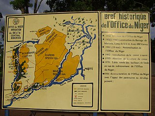
The Office du Niger is a semi-autonomous government agency in Mali that administers a large irrigation scheme in the Ségou Region of the country. Water from the Niger River is diverted into a system of canals at the Markala dam 35 kilometres (22 mi) downstream of Ségou. The water is used to irrigate nearly 100,000 hectares (390 sq mi) of the flat alluvial plains to the north and northeast of Markala that form part of the Delta mort. Although the French colonial administration constructed the system to produce cotton for the textile industry, the main agricultural product is now rice. Around 320,000 tons are grown each year representing 40 percent of the total Malian production. Large quantities of sugar cane are also grown in joint ventures between a Chinese company and the Malian state. The irrigation scheme uses 2.7 km3 (0.65 cu mi) of water each year corresponding to around 10 percent of the total flow of the Niger River.
King Fahd or Fahd of Saudi Arabia (1921–2005) was a Saudi monarch.
References
- ↑ 3è pont de Bamako : Le Chantier se Précise à l'Horizon Archived 14 February 2012 at the Wayback Machine . L'Essor, 21 May 2007.
